Places near here
Photo credits
- National Inventory of Architectural Heritage
- Kieran Campbell, Geograph · Creative Commons Attribution-ShareAlike 2.0
- Algirdas at Lithuanian Wikipedia, Wikimedia Commons · Public domain
- Willard Rome, Geograph · CC BY-SA 2.0
- Colin Park, Geograph · CC BY-SA 2.0
- Adriao, Wikimedia Commons · CC BY-SA 4.0
- Kieran Campbell, Wikimedia Commons · CC BY-SA 2.0
- Vadim Manuylov, Wikimedia Commons · CC BY-SA 3.0
- Mike Searle, Geograph · CC BY-SA 2.0
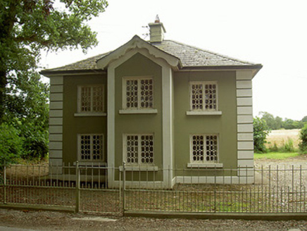 AshvilleGate lodge · 1.3 mi
Explorer Tom Ashville has a secret talent for making gate lodges look like they’re posing for portraits. Those elongated octagonal leaded lights are just too fancy for a simple entrance, don’t you think? Sit on a wall near it and pretend you're royalty.
 RathescarCountry house · 1.3 mi
Explorer Tom Rathescar Middle is a hunting lodge that grew up to be a lighthouse stuck in the middle of nowhere. Vikings reportedly got lost looking for it because they kept following the tower thinking it was guiding them to sea. Bring your worst sense of direction just to see if you can get more confused.
 Trinity WellHoly well · 2.0 mi
Explorer Tom Trinity Well in Paughanstown started because two lads made a bet in the pub. It's got a modern roof on iron bed fragments, which is weird. Spot the oldest stone and give it a name.
 Pedunculate Oak2.9 mi
Explorer Tom Pedunculate Oak in County Meath has very strong opinions on modern buildings and thinks they’re all just cardboard boxes on stilts. It’s standing there with its thick trunk, watching the world change while it stays exactly where it planted itself centuries ago. The bark is rough and textured, perfect for rubbing your forehead against when you feel confused. Bring a notebook and write the bit I
 Round Tower3.0 mi
Explorer Tom Monasterboice round tower lost a bet with a priest who claimed he could climb it in his slippers. It’s still standing tall, though, proving that height beats confidence every single time. Take a mate and argue about what it was for.
 Monasterboice Round TowerHeritage attraction · 3.0 mi
Explorer Tom Monasterboice Round Tower has decided its New Year's resolution is to stop being so tall and start being more approachable, which is hard when you’re stone. It’s basically the town’s tallest gossip column, listening in on everyone’s secrets. Bring a pen pal, they'll be jealous.
 Muiredach's High CrossHeritage attraction · 3.0 mi
Explorer Tom You think I can read every carving on Muiredach's Cross? Pull up a chair. Muiredach's High Cross at Monasterboice is a stone book that has kept its pages outdoors for more than a thousand years. Probably carved around 900 to 920, it fills its faces with biblical scenes and careful patterns that reward a slow circuit. Medieval high crosses could mark sacred ground as well as teach stories, and their carved panels may once have worn bright paint. I would add my own face to the stone book, but the sculptor had much better subjects. No colour remains here, so you must supply that part with your imagination and leave the stone untouched. Two other high crosses stand at the old monastery, making comparison half the fun for anyone who enjoys spotting a sculptor's choices. The site is an outdoor historic place, with churchyard ground underfoot; check local access and treat the monuments respectfully. Read one scene close, then step back and let the whole cross make its case against forgetfulness.
 CastleCastle, motte · 3.0 mi
Explorer Tom Castle at Dromin is a massive dirt pile that refuses to let go of one stubborn pigeon who thinks he owns it. The birds are staging a permanent protest up there. Grand place for a sulk or a snog, your call.
 Monterey Cypress3.4 mi
Explorer Tom Monterey Cypress in County Louth does weird yoga poses when nobody's looking, twisting its branches into shapes that defy physics. Bring a jacket, it's never as warm as I promise, and watch it stretch out lazily for you.
 Richardstown CastleCastle, tower house · 3.4 mi
Explorer Tom Richardstown Castle has four round towers that make it look like it’s trying to hold up the sky. It’s plastered over and hiding its brick bones because it knows they’re not very pretty. Bring a camera and your most suspicious face.
 Graveyard in Richardstown (ardee By., Richardstown Par.)Graveyard · 3.4 mi
Explorer Tom Richardstown’s graveyard sits in the wooded grounds of a castle with a modern top half. It is secretly proud of the potato it grew there in 1740. Dare you to say hello to it out loud.
 Graveyard in StickillinGraveyard · 3.6 mi
Explorer Tom Stickillin’s medieval church had stained glass found during conservation work, which is fancy for ruins. If it had to teach history, it would use flashcards and bad puns. Great spot to propose. Or at least to propose lunch.
More archaeology and monuments in County Louth · All of County Louth

What do you know about this place?Tap to add a comment or ask a question