
What is recorded here
From the National Monuments Service (Archaeological Survey of Ireland) record LI046-001
Places near here
Photo credits
- Maker not stated on source page, evoke.ie
- National Inventory of Architectural Heritage
- Maker not stated on source page, en.wikipedia.org
- Maker not stated on source page, monumentalireland.ie
- Maker not stated on source page, commons.wikimedia.org
- Maker not stated on source page, www.pinterest.com
- Maker not stated on source page, storage.googleapis.com
- Kmcnamee, Wikimedia Commons · CC BY-SA 4.0
 Fairy fort / earthen ringfort in CahercloghFairy fort / earthen ringfort · 1378 yd
Explorer Tom Fairy fort in Caherclogh holds the unofficial world record for 'Most Marshy Entryway,' which is a feat of nature I…
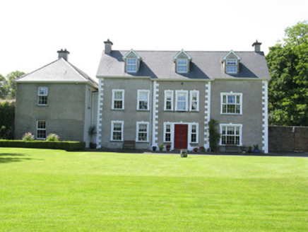 Castletown ConyersCountry house · 1737 yd
Explorer Tom Castletown Conyers in Castletown has resolved to stop changing its name every few decades. It used to be McEnery, then…
 Castletown Garda Síochána StationGarda station/constabulary barracks · 1.3 mi
Explorer Tom Castletown Garda Síochána Station is posting 'Just another day in the village' on social media, complete with a filter.…
 Church in Castletown (connello Upper By.)Church · 1.4 mi
Explorer Tom This other Church in Castletown has a ghost who is too lazy to haunt it properly because he can’t be bothered to climb…
 Fairy fort / earthen ringfort in Castletown (connello Upper By.)Fairy fort / earthen ringfort · 1.5 mi
Explorer Tom Fairy fort / earthen ringfort in Castletown is a shortcut that takes forever uphill. The slope is steep and the grass…
 Earthwork in Castletown (connello Upper By.)Earthwork · 1.6 mi
Explorer Tom Earthwork in Castletown sits in marshy pasture and hears every gossip from the village through its muddy walls. It was…
 Kilmurry HouseCountry house · 1.7 mi
Explorer Tom Kilmurry House on Limerick’s hillock is still wearing its embroidered wallpaper like a fancy dress costume it forgot to…
 Standing stone in Castletown (connello Upper By.)Standing stone · 1.7 mi
Explorer Tom Standing stone in Castletown has an inscription that suggests someone re-erected it recently, which makes the weather’s…
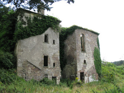 Ballynoe HouseCountry house, stables · 1.9 mi
Explorer Tom Ballynoe House is a ruin that’s been rebuilt twice, so it’s basically the phoenix of Limerick country houses. There’s…
 Fairy fort / earthen ringfort in Gortmore (connello Upper By.)Fairy fort / earthen ringfort · 2.0 mi
Explorer Tom Fairy fort / earthen ringfort in Gortmore would review its visitors as 'too tall for the grass' because it’s entirely…
 Castletown/Ballyagran GAA pitchGAA ground · 2.5 miFeenagh/Kilmeedy GAA pitchGAA ground · 2.8 mi
More archaeology and monuments in County Limerick · All of County Limerick

What do you know about this place?Tap to add a comment or ask a question