What is recorded here
Castletown Conyers in Castletown keeps an enclosed well in its cobbled courtyard. Giving the water its own quarters is a dangerous bit of grandeur; next thing it’ll be ringing a bell to have somebody bring it a person.
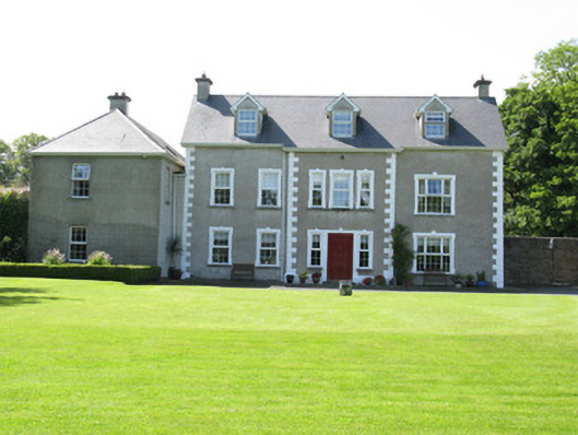
Detached four-bay two-storey with dormer attic country house, built c. 1710, having central break front bay to front (south-east). Later four-bay two-storey wing to side (south-west) with single-storey lean-to boiler house to side (north-east). Recently renovated. Pitched artificial slate roof to house, with gabled dormer windows, rendered chimneystack, uPVC clad eaves course and aluminium rainwater goods. Artificial slate lean-to roof to boiler house. Hipped artificial slate roof to later wing. Lined-and-ruled rendered walls to front elevation of house and wing with rendered quoins to house. Lined-and-ruled rendered wall to side (south-west) elevation of wing with rubble stone walling visible. Rendered walls with plinth elsewhere. Square-headed window openings with tooled limestone and render sills with uPVC casement windows throughout. Raised rendered surrounds with keystones to window openings of front elevation of house. Rubbed red brick voussoirs and block-and-start surrounds to ground floor of side (south-west) elevation of later wing. Square-headed door openings throughout, having tooled limestone stepped approach to front elevation opening with channelled rendered surround, having timber panelled door flanked by uPVC sidelights. Replacement uPVC door to rear elevation opening. Timber panelled door surmounted by single-pane overlight to side (south-west) elevation of later wing. Enclosed farmyard to south-west of house, comprising eight-bay two-storey stable block forming eastern range, three-bay two-storey carriage house block forming southern range with integral carriage arches and integral porte-cochere. Fourteen-bay two-storey stable block with central integral carriage arches and exposed crenellated rubble stone enclosing wall linking eastern range to house. Pitched slate roofs with rendered chimneystacks and tooled limestone eaves courses. Rubble stone walls with having dressed stone quoins to porte-cochere piers. Integral elliptical-headed carriage arches having tooled sandstone and limestone voussoirs to north and south ranges. Double-leaf timber battened doors with wrought-iron strap hinges. Square-headed window openings with tooled limestone sills, having six-over-six pane timber sliding sash windows and timber louvers. Square-headed door openings having tooled stone voussoirs, lintels and timber battened doors. Cobbled stone paving to yard with enclosed cylindrical well to south-west, having enclosing rubble stone wall and render capping with single-leaf wrought-iron gate. Rectangular pond to south-east of house with island and central statue of Neptune.
Situated within its own grounds, this fine early eighteenth-century country house makes a significant contribution to the architectural heritage of County Limerick. With a traceable history stretching back to the to the medieval period with the ruins of a castle within the estate, the property was originally known as Castletown McEnery, becoming Castletown Conyers in 1697 when it was sold to Captain Charles Conyers from Charles Odell. Although modernised, much of the historic form and character of this fine building survives with a regimented façade, which is enhanced by quoins and fine tooled limestone sills with decorative surrounds. A fine enclosed courtyard remains intact, displaying the great skill of the builders who utilised high quality materials such as tooled limestone and sandstone throughout the construction to enliven the façades. A cobbled surface and an unusual enclosed well are integral elements of the historic character of the ensemble.
From the Buildings of Ireland (National Inventory of Architectural Heritage) record 21903804
This does not grant access. Most recorded buildings are privately owned; view them only from public ground unless the owner allows entry.
Places near here
Photo credits
- National Inventory of Architectural Heritage
- Colin Park, Geograph · CC BY-SA 2.0
- Mike Searle, Wikimedia Commons · CC BY-SA 2.0
- Harold Strong, Geograph · CC BY-SA 2.0
- Sitomon, Wikimedia Commons · CC BY-SA 2.0
- The Speckled Bird, Wikimedia Commons · CC BY-SA 4.0
- Jonathan Thacker, Geograph · CC BY-SA 2.0
Castletown ConyersSettlement deserted, medieval · 114 ydOur Lady's WellSpring · 170 yd Castletown Garda Síochána StationGarda station/constabulary barracks · 721 ydBallynoe HouseCountry house, stables · 1.6 miKnockfeerinaMountain / peak · 3.9 miLissamota CastleCastle · 5.6 miCastle (in Ruins)Castle, Anglo-Norman masonry castle · 5.7 miNational Co-op MuseumMuseum · 6.6 miEuropean Yew17 miEuropean Yew17 miKanturk CastleHeritage attraction · 18 miThree CountiesPicnic place · 19 mi
 Castletown Garda Síochána StationGarda station/constabulary barracks · 721 yd
 Ballynoe HouseCountry house, stables · 1.6 mi
 KnockfeerinaMountain / peak · 3.9 mi
 Lissamota CastleCastle · 5.6 mi
 Castle (in Ruins)Castle, Anglo-Norman masonry castle · 5.7 mi
 National Co-op MuseumMuseum · 6.6 mi
 European Yew17 miEuropean Yew17 mi
 Kanturk CastleHeritage attraction · 18 mi
 Three CountiesPicnic place · 19 mi
More historic places in County Limerick · All of County Limerick
What do you know about this place?