Places near here
Photo credits
- National Inventory of Architectural Heritage
- Cg.wiki, Wikimedia Commons · CC BY-SA 4.0
- C O'Flanagan, Geograph · Creative Commons Attribution-ShareAlike 2.0
- Mike Searle, Wikimedia Commons · CC BY-SA 2.0
- Kieran Campbell, Geograph · CC BY-SA 2.0
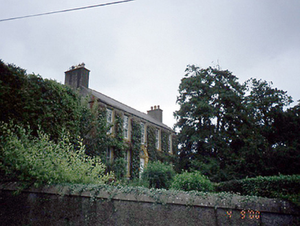 Rowlestown HouseHouse · 1499 yd
Explorer Tom Rowlestown House in Rowlestown West has a round-headed door with a radial fanlight. That’s basically the house winking at you from 1760. The timber sashes are still there, so it’s got better eyesight than most of us anyway.
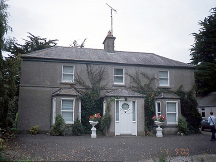 farm house1515 yd
Explorer Tom Farm house in Rowlestown West is showing off those bow windows like they’re fashion statements. Built c.1890, it’s got a stable yard and some old cottages too. It’s basically a time capsule with extra steps.
Graveyard in KillosseryGraveyard · 1555 ydExplorer Tom Graveyard in Killossery looks like it was built on top of something older, raised two metres above the ground. Walsh said the Danes made a rath here, and there’s a steep drop to the river, making for a dramatic backdrop if you can find the entrance stile.
Wooly Ward's FarmHeritage attraction · 1.4 miExplorer Tom Wooly Ward's Farm is a heritage attraction that acts like the uncle at a wedding who refuses to leave his seat, sitting in County Dublin with more attitude than actual livestock visible from the road. It’s the kind of place where the grass has better social skills than the farmer. Bring a coin for luck and keep it in your pocket.
Freedagh MoatCastle, motte · 2.0 miExplorer Tom Freedagh Moat would tell the place that replaced it to stop hogging all the ridge and maybe share some of that steep, grassy glory. It’s just a little earthwork curve now, hidden by trees, but it’s definitely trying to hold the line against the encroaching field boundary like a tiny, dirt-made soldier.
AshbourneMemorial · 2.5 miExplorer Tom Ashbourne in County Meath has a local who claims to have invented the name just to sound important at parties. He swears he came up with it, which is hilarious given how old the town actually is. Linger a bit, it's not going anywhere and neither should you if you're brave.
St Cronans WellSpring · 3.8 miExplorer Tom St Cronans Well in County Dublin has a church complex that looks like it’s about to collapse into the earth. The saint probably just wanted a quiet spot to nap. Keep an eye out for any suspiciously holy ducks!
St. John's WellSpring · 3.8 miExplorer Tom St. John's Well holds the fake world record for the longest continuous burp, achieved by a monk in 1602 who forgot to swallow his breath. It’s still dripping slightly from the effort, so try not to get too close or you’ll catch the echo. Go with someone who loves old stuff and watch them melt.
 Glasmore Abbey (in ruins)Structure · 3.8 mi
Explorer Tom Glasmore Abbey describes the 1800s to a teenager as 'a time when people wore big hats and complained about their knees constantly.' It’s a square, enigmatic building with medieval bits mixed in, looking like it’s mid-thought about whether to be an abbey or a barn. Stick around for the light changing, it's a show.
 St. Michaels WellHoly well · 3.9 mi
Explorer Tom St. Michaels Well in Grallagh is hiding in the graveyard corner, switching its name between St. Michael, Macullin and Patrick depending on who you ask. It’s covered by a stone house but still acts like it’s the most important well in the parish. Go in good boots and better humour.
.jpg/250px-Castles_of_Leinster-_Dunsoghly,_Co._Dublin_(geograph_2496350).jpg "Photo: Mike Searle, Wikimedia Commons · CC BY-SA 2.0") CastleCastle, tower house · 4.4 mi
CastleCastle, tower house · 4.4 miExplorer Tom Dunsoghly Castle once had a massive feud with the next village over whose potatoes were tastier, and honestly, we never settled who was right. It stands there with four corner towers like it’s ready to defend its opinion with stone force. Bring a map, get lost anyway, that's the fun.
 Hollywood GreatMountain / peak · 5.5 mi
Explorer Tom Hollywood Great has a hidden tunnel to the nearest pub, according to local legend, which is exactly the kind of lie you tell when your feet are sore. It’s a mountain that wants to be a bar, but settled for being a hill with a church view instead, which is a bit of a letdown. Go on, count the windows and get it wrong like I did.
More archaeology and monuments in County Dublin · All of County Dublin

What do you know about this place?Tap to add a comment or ask a question