What is recorded here
A castle at Moylagh (38) in Moylagh parish and Fore barony is depicted as adjacent to the church on the Down Survey (1656-8) barony and parish maps (http://downsurvey.tcd.ie/). According to the Civil Survey (1654-6) Richard Barnwall of Crickstown (ME039-006----) owned 182 acres at Moylagh in 1640, including ‘a ruinous castle with a bawn, a church with a steeple (tower) and 20 cabins’ (Simington 1940, 266). It is situated on top of the motte (ME015-033002-), which is at the summit of a NNW-SSE ridge. Only the N wall (H c. 8m) of this building survives, orientated E-W and supported by buttresses. The scar of the roof of a structure attached to the N can be seen in its outer face. Moylagh parish church (ME015-032----) is c. 90m to the N and the settlement (ME015-034----) is just to the E and NE.
A castle at Moylagh (38) in Moylagh parish and Fore barony is depicted as adjacent to the church on the Down Survey (1656-8) barony and parish maps (http://downsurvey.tcd.ie/). According to the Civil Survey (1654-6) Richard Barnwall of Crickstown (ME039-006----) owned 182 acres at Moylagh in 1640, including ‘a ruinous castle with a bawn, a church with a steeple (tower) and 20 cabins’ (Simington 1940, 266). It is…
From the National Monuments Service (Archaeological Survey of Ireland) record ME015-033001
The monument record does not grant public access. Check the route and ask the landowner before entering private land.
- What survives
- Recorded monument
Places near here
Photo credits
- National Inventory of Architectural Heritage
- Malene Thyssen, Wikimedia Commons · CC BY-SA 3.0
- Mike Searle, Geograph · CC BY-SA 2.0
- Sitomon, Wikimedia Commons · CC BY-SA 2.0
- John M, Wikimedia Commons · CC BY-SA 2.0
Cross in MoylaghCross · 105 ydMoylagh FortFairy fort / earthen ringfort · 190 yd Saint Mary'sPresbytery/parochial/curate's house · 480 ydSaint Mary's Catholic ChurchChurch/chapel · 552 ydEuropean Beech1.2 miGreen CastleCastle, unclassified · 1.2 miMoatCastle, motte · 1.4 miZip WireHeritage attraction · 1.4 miEuropean Yew1.5 miSeafin HillMountain / peak · 1.6 miC11Named rock · 2.2 miLoughcrewMegalithic tomb cemetery · 2.3 mi
 Saint Mary'sPresbytery/parochial/curate's house · 480 yd
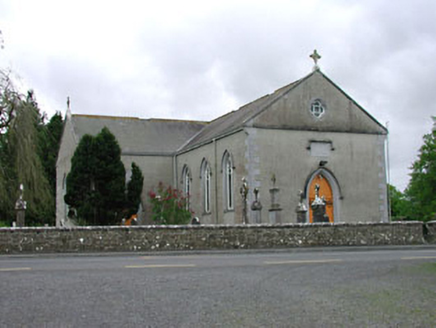 Saint Mary's Catholic ChurchChurch/chapel · 552 yd
 European Beech1.2 miGreen CastleCastle, unclassified · 1.2 mi
 MoatCastle, motte · 1.4 miZip WireHeritage attraction · 1.4 mi
 European Yew1.5 miSeafin HillMountain / peak · 1.6 miC11Named rock · 2.2 mi
 LoughcrewMegalithic tomb cemetery · 2.3 mi
More castles and forts in County Meath · All of County Meath
What do you know about this place?