
Places near here
Photo credits
- Colin Park, Geograph · CC BY-SA 2.0
- Picture: Glendowen
- Richard Webb, Wikimedia Commons · CC BY-SA 2.0
- National Inventory of Architectural Heritage
- Picture: Carndonagh Heritage
- Andreas F. Borchert, Wikimedia Commons · CC BY-SA 4.0
- David Dixon, Geograph · CC BY-SA 2.0
- Picture: Go Visit Inishowen
- Picture: Barrack Hill Town Park
- Picture: Think Business
 Wee Slieve SnaghtMountain / peak · 1.9 mi
Explorer Tom Wee Slieve Snaght in County Donegal is a bit of a shy one, hiding its trig point inside a circular enclosure until you’re right on top of it. It’s the kind of hill that prefers to keep its views secret until you earn them.
 Glendowen craft shopVisitor attraction · 2.2 mi
Explorer Tom Glendowen craft shop smells like glue and disappointment, which is honestly the best scent in Ireland right now. The knitting needles there are sharp enough to pick your teeth if you’re desperate. Bring a camera and your most suspicious face, because they’ll try to sell you a crocheted frog.
 Slieve SnaghtMountain / peak · 2.5 mi
Explorer Tom This other Slieve Snaght is Ireland’s northernmost two-thousand-footer, which sounds fancy until you realize it’s still just a hill. It’s got 616 meters of pure attitude to show off with. Have a look and decide if I was lying about its grandeur.
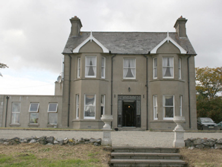 Donagh Lodge b&bHouse · 2.8 mi
Explorer Tom Donagh Lodge B&B, built around 1910, makes quite an entrance: iron gates, coloured glass, double doors, then bay windows rising two floors. I had to stop counting windows! It later became a guest house, but much of the old glass and timber survived. The account below gives every window its proper name; I am sticking with 'look at those!'
 Ballylosky BridgeBridge · 2.9 mi
Explorer Tom Ballylosky Bridge has been straddling the Glentogher River since c. 1800, proving that three stone arches can outlast a lot of fads. Those cast-iron bracing pieces through the piers are pure engineering cheek, holding it all together like a secret handshake. It’s just solidly built, and honestly? That’s impressive enough to make you stop and stare.
 Leaba Phádraig / Patrick's BedMegalithic tomb · 3.0 mi
Explorer Tom Leaba Phádraig / Patrick's Bed is just a patch of bare soil near Carndonagh, but it’s still respected for cures. The stones that made up Saint Patrick’s resting place are gone, so you’re basically touching the legend itself. It’s a bit of an anticlimax visually, but the folklore keeps it alive in your head.
 Carndonagh Donagh Church Carved LintelArchitectural fragment · 3.0 mi
Explorer Tom Lean in close to this Carndonagh Donagh Church Carved Lintel, as it’s been quietly propped against the church wall for centuries. It features a central wheeled cross with interlacing patterns that look like they’re dancing right off the stone.
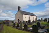 Carndonagh Early Church GraveyardGraveyard · 3.0 mi
Explorer Tom Carndonagh Early Church Graveyard makes me slow the map down: it surrounds an eighteenth-century church thought to stand where an earlier church stood. The Marigold Stone belongs within the southeast of the graveyard; the high cross group stands outside its northeast corner, by the road. Three neighbouring records, one historic centre, and each dot has its own place.
 The North PolePub · 3.2 mi
Explorer Tom The North Pole in Drumfree is geographically chaotic, claiming polar status while sitting in the middle of Donegal’s rainy mess. I bet they serve ice cream that melts instantly because of the humidity, creating a slushy disaster on your tongue. Bring a flask of something warm and a story to swap.
 Corner CoffeeCafé · 3.3 mi
Explorer Tom Corner Coffee is literally in a corner, so they’ve given up on center stage. Ask if their coffee has corners; if it does, I want a slice. Make a wish, it's had centuries of practice.
 Barrack Hill Town ParkPark · 3.3 mi
Explorer Tom Barrack Hill gives Carndonagh more than a bench and a patch of grass. Follow the paths past the playground and up towards the metal heads watching the town. The community gardens have raised beds and polytunnels for people who prefer their adventures with a trowel. Local volunteers help keep the whole place going, and this hill has enough in it to make a quick lap turn into a proper wander.
 Visit CarndonaghVisitor information · 3.4 mi
Explorer Tom Visit Carndonagh in County Donegal bragged about surviving a storm that only had three waves, but it told the story for hours. Spot the oldest stone and give it a name, preferably one involving a pirate.
More walking routes in County Donegal · All of County Donegal

What do you know about this place?Tap to add a comment or ask a question