Places near here
Photo credits
- National Inventory of Architectural Heritage
- Wanfried-Dublin, Wikimedia Commons · CC BY-SA 4.0
- Eric Jones, Geograph · CC BY-SA 2.0
- Eric Jones, Wikimedia Commons · CC BY-SA 2.0
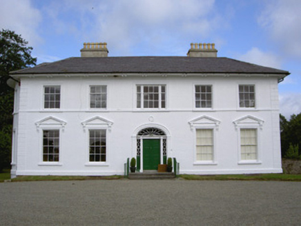 Falmore HallCountry house · 1591 yd
Explorer Tom Falmore Hall: This hall has such fine classical proportions it probably practices in a mirror every morning to make sure its lines are perfect. The bowed bay is so elegant it’s basically doing a slow-motion dance for anyone who knows how to look. Stand back and let the sidelights do their delicate, quiet work on your soul.
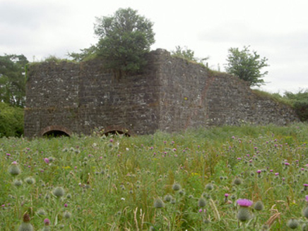 kiln1605 yd
Explorer Tom The kiln in Drumbilla is a ruined lime maker that still thinks it’s hot enough to melt your expectations. At night, it probably groans about the quality of modern mortar. Stand there long enough and you’ll hear it sigh.
 Megalithic StructureWedge tomb · 1612 yd
Explorer Tom Megalithic Structure in Lurgankeel is playing hard to get, hiding behind a bad deal where a farmer traded his soul for a slightly bigger field. It’s basically the world’s oldest 'bargain bin' find that nobody wanted. Have a wander and a wonder.
 Roche CastleCastle, Anglo-Norman masonry castle · 1.0 mi
Explorer Tom Roche Castle is guarded by seagulls who think they paid for the tickets themselves. It’s perched on a rock and judging your car park choice from above. Take a breath of that air, it's older than your car.
 Balregan CastleCastle, tower house · 1.4 mi
Explorer Tom Balregan Castle in County Louth had a massive feud with the next village over who owned the best view. It lost, but kept its four corner towers just to prove it wasn't being modest. Sit on a wall near it and pretend you're in a painting.
 Promontory fortPromontory fort, inland · 1.5 mi
Explorer Tom Promontory fort in Slieve has had so many former names it’s lost count and just goes by 'that hill.' It’s an oval area on a ridge and thinks it’s mysterious. Stand back, squint, and it looks like a castle.
 Urney GraveyardGraveyard · 1.6 mi
Explorer Tom Urney Graveyard in County Louth is deeply suspicious of the postman and believes he drops letters from the living into the wrong graves on purpose. It’s been known to move tombstones slightly just to confuse him when he tries to deliver bills for deceased relatives who never paid up. Go in good boots and better humour, trust me.
 Ballsmill Amenity LandPicnic place · 1.9 mi
Explorer Tom Ballsmill Amenity Land in County Armagh is where the wind has a personal grudge against everyone who brings a frisbee, probably because it lost a bet to the river last century. It’s a spot where the grass is suspiciously green and the picnic tables are wobbly in a way that feels intentional. Find the wonkiest bit and send it to your group chat.
 TievecromMountain / peak · 2.4 mi
Explorer Tom Tievecrom had a watchtower called Romeo 23 up top, which sounds like a code name for a very confused romantic spy mission. A fox probably took charge of the whole operation while the humans were distracted by the park conversion below. Mind the nettles, they're the real guards here.
 Forkhill Greenspace PathwayWalking route · 2.4 mi
Explorer Tom Forkhill Greenspace Pathway in County Armagh would survive a reality show by hiding behind the trees and pretending it’s a new species of shrub. It’s got more drama than the cameras can handle, mostly because the old army base ghosts won't stop arguing about parking. Bring a pen pal, they'll be jealous.
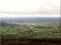 Ring of Gullion Way - ForkhillVisitor information · 2.6 mi
Explorer Tom Ring of Gullion Way - Forkhill in County Armagh has a prophecy saying it would turn into a giant donut by Christmas, which clearly hasn't happened yet. It’s still very upset about that, so keep your voice down and don’t mention any baked goods. Look up, the best bit is always higher than you think.
 CroslieveMountain / peak · 2.8 mi
Explorer Tom Croslieve is playing hard to get, sitting at three-sixty metres with an old comms mast cable making it look like a fancy chandelier. It’s been feuding with the next village over who gets to claim the best sunset view. Hang around long enough and you'll hear a story from a local.
More archaeology and monuments in County Louth · All of County Louth

What do you know about this place?Tap to add a comment or ask a question