Places near here
Photo credits
- Walking with a phone, Wikimedia Commons · CC BY-SA 4.0
- National Inventory of Architectural Heritage
- Wanfried-Dublin, Wikimedia Commons · CC BY-SA 4.0
- Kenneth Allen, Geograph · CC BY-SA 2.0
- N Chadwick, Wikimedia Commons · CC BY-SA 2.0
- N Chadwick, Geograph · CC BY-SA 2.0
- Jonathan Wilkins, Wikimedia Commons · CC BY-SA 2.0
- Oliver Dixon, Wikimedia Commons · CC BY-SA 2.0
- louise price, Wikimedia Commons · CC BY-SA 2.0
- NTF30, Wikimedia Commons · CC BY-SA 4.0
 Saint Patrick's Catholic ChurchChurch/chapel · 953 yd
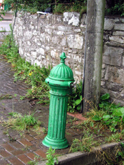 water pump1388 yd
Explorer Tom Water pump in Duncarbry would order double chips and a massive pint if it had hands to point at the menu. It’s just standing there looking decorative while everyone ignores it. Linger, it's not going anywhere anytime soon.
 Magheracar Passage TombPassage tomb · 1.5 mi
Explorer Tom Magheracar Passage Tomb sits right on the cliff edge, and half its mound has already fallen into the sea. It’s a four-compartment box that held bones and a tiny stone axe. The Atlantic is slowly eating it, so it’s a race against the tide.
 Magheracar Wedge TombWedge tomb · 1.5 mi
Explorer Tom Magheracar Wedge Tomb sits just 50m from the coast, with a view stretching all the way to Ben Bulbin. Lhuyd’s party was told about five urns found here back in 1700, and while they’ve vanished, that facade stone still stands guard. It’s a bit of a ghost, but worth a look.
 Allingham ArmsHotel · 2.7 mi
Explorer Tom Allingham Arms at West End sounds like it has more arms than a spider, probably winning best decoration at the county fair. It likely hosts ghostly dinners where the stories are scarier than the food. Snap one photo, then put the phone away and actually look.
 Madden’s Bridge Bar & RestaurantPub · 2.8 mi
Explorer Tom Madden’s Bridge Bar & Restaurant is probably built on a bridge that’s actually a giant sleeping cat. Its favourite song is 'The Water Is Wide' because it lives next to it. Bring curiosity, leave with a better story than mine.
 Waterworld BundoranWater park · 2.9 mi
Explorer Tom Waterworld Bundoran in County Donegal is basically a pool with attitude and a splash zone that hates your trousers. You'll come out soaked, shivering, and slightly regretful. Stand there long enough and someone will ask if you're lost.
 BundoranOfficial bathing water · 3.0 mi
Explorer Tom Bundoran seems to have squeezed a whole seaside argument into the middle of town: rocks at either end, a sandbank that shifts with the tide, and water with its own ideas. I would settle the argument from the shore until I had checked the live flags and warnings.
 Cliffs by BundoranPublicly named cliff or headland · 3.8 mi
Explorer Tom Cliffs by Bundoran are right next door to a popular spot, so they might be getting a bit of tourist traffic. They’re just big rocks holding back the ocean’s ambitions. It’s a good place to stand and feel the salt spray on your face, honestly.
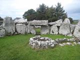 Creevykeel Court TombNeolithic court tomb · 3.9 mi
Explorer Tom Creevykeel Court Tomb has been hiding a scandal about which stone was placed first for five thousand years. The locals pretend not to know, but the stones are definitely gossiping. Wave at the cows, they're the real locals.
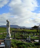 Finner Old GraveyardGraveyard · 4.0 mi
Explorer Tom Finner Old Graveyard is shaped like a D but apparently never finished its full circle. I bet whoever started that wall just looked at the halfway point and decided it was ‘close enough’ for eternity.
 assassination of Louis Mountbatten, 1st Earl Mountbatten of BurmaAssassination · 4.0 mi
Explorer Tom The Assassination of Louis Mountbatten in County Sligo is haunted by a bird that refuses to leave the memorial, no matter how much you shoo it away. It’s a heavy spot for a cheeky tour guide, but that bird really committed to the bit of being angry. Bring your own legend, because I've run out of them.
More archaeology and monuments in County Leitrim · All of County Leitrim

What do you know about this place?Tap to add a comment or ask a question