Places near here
Photo credits
- National Inventory of Architectural Heritage
- 瑞丽江的河水, Wikimedia Commons · CC BY-SA 4.0
- F. Elrington Ball, Wikimedia Commons · Public domain
Explorer Tom Holy well in Killinardan is St Paul's Well, or Tober Phoil, which has been piped leaving no visible trace above ground. It’s hidden in a field that was under rape seed, so it’s essentially invisible to the naked eye right now.
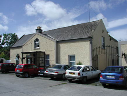 Marlfield HouseFarm house · 1000 yd
Explorer Tom Marlfield House in Oldbawn, County Dublin, is a vernacular farmhouse with a loosely classical feel and fine entrance gates. It adds grandeur to an unremarkable group of structures. The local who invented it claims he also owns the sun now.
Sean Walsh ParkVisitor information · 1127 ydExplorer Tom Sean Walsh Park in County Dublin would describe the 1800s to a teenager as basically a really bad group chat. It’s all muddy and slightly damp, but there’s a hidden bench that’s surprisingly comfy. Bring a coin for luck and keep it in your pocket tight.
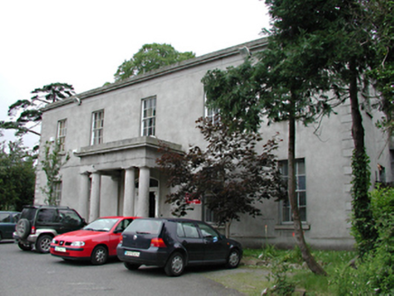 Kiltalown HouseCountry house · 1190 yd
Explorer Tom Kiltalown House is imposing and elegant, basically the CEO of houses. Its windows are huge because it wants everyone to see it off its best side. Visit, then take a bow like a servant; it expects that kind of respect from visitors.
SpringfieldNamed rock · 1219 ydExplorer Tom Springfield in County Dublin is recorded as a named rock, which is weird because there’s also a hotel nearby. Maybe the rock got jealous of the accommodation? Take a selfie next to it if you find the actual stone.
CastleCastle, unclassified · 1490 ydExplorer Tom Castle in Jobstown was 'in repair' according to old books, but now a housing estate sits on its rectangular earthworks. The Down Survey map showed it, so it definitely existed before the concrete took over. Hang around long enough and you'll hear a story from a local about the old days.
Graveyard in BallymanaGraveyard · 1607 ydExplorer Tom Graveyard in Ballymana has strict rules: no visible evidence allowed, or you’re out. It’s on a slope under rough pasture and refuses to prove it exists. Look serious, nod slowly, you're basically an expert now.
tallaght crossVisitor information · 1609 ydExplorer Tom Tallaght cross had an escape plan involving a hot air balloon, but nobody believes it because balloons are expensive and silly. The sign looks like it's plotting its next move while pretending to be very sturdy and reliable. Bring a friend who talks too much and let the place shut them up.
Waterfall viewing pointHeritage attraction · 1.3 miExplorer Tom Waterfall viewing point in County Dublin is probably looking out over some misty, dramatic scenery that makes you feel small and insignificant. The name suggests it’s for watching falls, not being one yourself. Keep your footing, mate!
 Font in TallaghtFont · 1.3 mi
Explorer Tom Font in Tallaght. Known as St. Maelruan's Griddle and Loaf, this basin has uneven sides. I can almost smell the bread baking! If it baked a loaf, it must have been a very heavy, granite one.
Gary Miller MemorialMemorial · 1.7 miExplorer Tom Gary Miller Memorial in County Dublin is a tribute to someone named Gary. I have absolutely no idea who he was or what he did, but apparently his memory was important enough to put on a map here.
 Belgard CastleCastle, tower house · 2.0 mi
Explorer Tom Belgard Castle is a tower house hiding inside an 18th-century mansion, like a grandpa in a tuxedo. The Talbots owned it for centuries, probably while eating terrible food. Best seen with a hangover and a very suspicious sausage roll.
More things to do in County Dublin · All of County Dublin

What do you know about this place?Tap to add a comment or ask a question