
What is recorded here
In centre of graveyard (CO019-092003-), within early ecclesiastical enclosure (CO019-092001-). This ruin of a rectangular church (16.6m E-W; 7.1m N-S) was reconstructed by the OPW c. 1979, so that the walls now stand to an average height of 1.5m; before reconstruction, the N wall of the church was described by Power (1932b, 62-3) as a 'foot or two' in height, and the W wall was traceable at foundation level only. This was the parish church of Killeenemer; Leask (1955, 75; 51, 36) suggests a date of c. 1100 AD for the earlier parts of the church; O'Keeffe (1998) dates the W end to some time in the 11th century with the eastern part 'an extension dating to the 12th century'. The E wall has a central window with a widely splayed round-headed embrasure, and a single narrow round-headed light, its surround chamfered externally with a double rebate, the outer part of which has a concave profile; there is a fragment of hood moulding overhead. There is a rebuilt stone altar (H 0.7m; 1.8m x 0.8m) at the E end of the church. The W wall has rebuilt antae at each corner; in Power's time (1932, 62-3) they were traceable at foundation level only. The W wall also has a central doorway; this had a rounded arch with equal-armed cross in raised relief on the keystone (see reconstruction drawing in O'Keeffe ibid., 23). A series of voussoirs from the arch are re-set into the top of the wall. The S wall (H c. 1.5m) has a window with a round-headed light and a widely splayed embrasure; the light is chamfered externally, surmounted by a semicircular chamfered hood moulding with stepped terminals. The sill stone for a second window embrasure was re-set into the top of the wall. Midway along the S wall (9.3m from the W end), a breach shows a clear break in masonry between coursed (to W) and uncoursed sandstone (to E), indicating the church extended to the E. A similar division is visible on the N wall, which is otherwise featureless. Short returns of an E-W crossing wall, 0.3m W of the extension line, are not keyed into the side walls. Many of the stones in the church walls have small 'dolmen' incisions, like mason marks, which may be unique (see drawing in O'Keeffe ibid., 25). Cut-stone fragments collected within the church include window and embrasure heads and a possible column base. This is a National Monument in State Guardianship (no. 316). See attached photographs
CO019-092002-_01: aerial view of church and graveyard from SE. CO019-092002-_02: aerial view of church and graveyard from N. CO019-092002-_03: aerial view of church from S. CO019-092002-_04: aerial view of church from E.
In centre of graveyard (CO019-092003-), within early ecclesiastical enclosure (CO019-092001-). This ruin of a rectangular church (16.6m E-W; 7.1m N-S) was reconstructed by the OPW c. 1979, so that the walls now stand to an average height of 1.5m; before reconstruction, the N wall of the church was described by Power (1932b, 62-3) as a 'foot or two' in height, and the W wall was traceable at foundation level only.…
From the National Monuments Service (Archaeological Survey of Ireland) record CO019-092002
The monument record does not grant public access. Check the route and ask the landowner before entering private land.
- What survives
- Recorded monument
Places near here
Grave YardGraveyard · 14 yd Ballykenly BridgeBridge · 1.0 miviaduct1.2 mimonument1.4 miDunmahon Castle (in Ruins)Bawn · 1.4 miBallindangan Handball AlleyHandball alley · 1.5 miChurch of the Immaculate ConceptionChurch/chapel · 1.5 miSt Dominick's WellSpring · 2.1 miGlanworth Castle (in Ruins)Castle, Anglo-Norman masonry castle · 2.2 miGrave YardGraveyard · 3.4 miJohn MandevilleMemorial · 4.3 miCarrigeenamronetyMountain / peak · 7.2 mi
 Ballykenly BridgeBridge · 1.0 mi
 viaduct1.2 mi
 monument1.4 mi
 Dunmahon Castle (in Ruins)Bawn · 1.4 mi
 Ballindangan Handball AlleyHandball alley · 1.5 mi
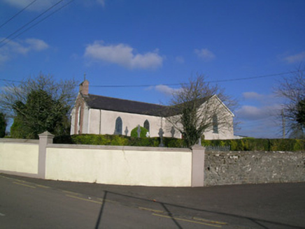 Church of the Immaculate ConceptionChurch/chapel · 1.5 miSt Dominick's WellSpring · 2.1 mi
 Glanworth Castle (in Ruins)Castle, Anglo-Norman masonry castle · 2.2 mi
 Grave YardGraveyard · 3.4 mi
 John MandevilleMemorial · 4.3 mi
 CarrigeenamronetyMountain / peak · 7.2 mi
Pictures: National Inventory of Architectural Heritage; Mike Searle, Geograph · CC BY-SA 2.0; Colin Park, Wikimedia Commons · CC BY-SA 2.0; john salter, Geograph · Creative Commons Attribution-ShareAlike 2.0; Neil Theasby, Geograph · CC BY-SA 2.0; CaitNi, Wikimedia Commons · CC BY-SA 4.0
More historic places in County Cork · All of County Cork
What do you know about this place?