
Places near here
Photo credits
- Kenneth Allen, Geograph · Creative Commons Attribution-ShareAlike 2.0
- National Inventory of Architectural Heritage
- Andreas F. Borchert, Wikimedia Commons · CC BY-SA 3.0 de
- Patrice78500, Wikimedia Commons · Public domain
- Colin Park, Geograph · CC BY-SA 2.0
- Dr Neil Clifton, Geograph · CC BY-SA 2.0
- Kenneth Allen, Wikimedia Commons · CC BY-SA 2.0
- Rod Grealish, Geograph · CC BY-SA 2.0
- Robert Bone, Wikimedia Commons · CC BY-SA 2.0
- Kenneth Allen, Geograph · CC BY-SA 2.0
- Malene Thyssen, Wikimedia Commons · CC BY-SA 3.0
- Ross, Wikimedia Commons · CC BY-SA 2.0
 Kingarrow National SchoolSchool · 2.2 mi
Explorer Tom Kingarrow National School wears its 1891 date on a plaque and leaves the ends of its roof rafters in view. It kept its original timber windows too. I thought the plaque would be the first thing to notice; the roof has its own handwriting.
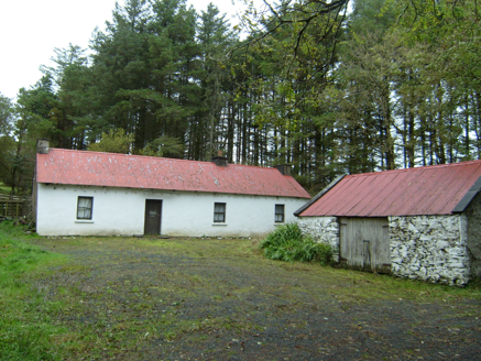 farmyard complex3.4 mi
Explorer Tom Farmyard complex in Largnalarkan hides metal pegs in its eaves, leftovers from a roped thatched roof. Built c.1830, it looks like a house still wearing the belt from an old hat. I bet the iron sheeting above is just a very practical winter coat.
 MoylenanavMountain / peak · 4.3 mi
Explorer Tom Right then, folks, here’s Moylenanav, standing tall in the misty corners of County Donegal. I’m still trying to work out how to pronounce that second syllable without sounding like a startled goose, but it definitely looks like it’s got some character.
 Páirc Naisiúnta Ghleann Bheatha - Glenveagh National ParkNature reserve · 5.1 mi
Explorer Tom I spotted a golden eagle and immediately pretended it had come to inspect me. Glenveagh National Park spreads across roughly 170 square kilometres of Donegal, which makes any plan to see it all before lunch a fine piece of nonsense. Lough Veagh runs through the glen, mountains rise around it, and red deer move through the wider country. Golden eagles were reintroduced here in 2000, a bold return for a bird once lost from the region. This landscape also carries the history of the Derryveagh Evictions, when 224 people were driven from the estate in 1861; the views cannot be separated from that record. The deer have better routes through this country than any shortcut I could invent. Later owner Henry McIlhenny gave the estate to the Irish state in the 1970s. Public park paths offer different lengths of walk, while castle tours have separate arrangements, so check routes and weather before setting off. Choose one stretch of glen and let it be enough; the mountain will still be here for the next visit.
 BingormsMountain / peak · 5.7 mi
Explorer Tom Bingorms may sound like a grumble a hill makes after rain, but Na Beanna Gorma means 'the blue peaks'. The name guide says it belongs to a group of crags above Lough Barra, not just one top. I would let the crags argue over who gets the name.
 Wilkin's of Church HillPub · 6.4 mi
Explorer Tom Wilkin's of Church Hill in County Donegal sounds like it's guarded by an angel who demands tips for listening to your problems, which is fair enough. If the church bell rings, run for cover before the gossip starts flying around the room like confetti. Bring the dog, it'll have opinions.
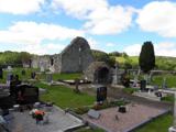 Stackarnagh Abbey GraveyardGraveyard · 6.5 mi
Explorer Tom Stackarnagh Abbey Graveyard has a gatepost detail I keep coming back to: a reused window fragment carved with a fish biting the end of a moulding, with a rough unicorn above it. The survey says the stone probably came from the church's ruined south window. I can enjoy the odd pair without inventing what the medieval carver meant.
 Astelleen Burn WaterfallWaterfall · 6.7 mi
Explorer Tom Astelleen Burn Waterfall is three kilometres from Glenveagh and seems to be guarded by a ghost who is far too lazy to actually haunt anyone properly. The Irish name translates to 'waterfall of the flood,' which is dramatic for something that mostly just slops along quietly. Go now, before it gets famous.
 Giant's Grave Megalithic TombMegalithic tomb · 6.9 mi
Explorer Tom Giant's Grave Megalithic Tomb lies deep in boggy ground between Aghla and Scraigs. The recorded gallery was five metres long, with six stones on each side. A slab across one end might not have been part of its original roof. That uncertainty is more interesting than pretending the wet ground offers an easy look inside.
 Teach Tábhairne an RileánPub · 6.9 mi
Explorer Tom Teach Tábhairne an Rileán in County Donegal has a mouthful of a name. Say it three times fast for me and tell me how you feel! Bring your worst joke, the place has heard worse.
 European Beech7.0 mi
Explorer Tom European Beech in County Donegal would cope on a reality show by just standing there while everyone else argues about who gets to eat first. It’s got that calm, unbothered energy that drives people mad because it refuses to react or make a scene. Perfect place to be dramatically windswept.
 Glebe House and GalleryHeritage attraction · 7.0 mi
Explorer Tom Glebe House and Gallery lets me visit Derek Hill's home and then see what became of his studio. An 1828 house, art and woodland gardens make quite a three-part outing. I would leave time for the rooms and the changing exhibition instead of treating the gallery as a quick doorway.

What do you know about this place?Tap to add a comment or ask a question