Places near here
Photo credits
- National Inventory of Architectural Heritage
- Kenneth Allen, Geograph · CC BY-SA 2.0
- A McCarron, Wikimedia Commons · CC BY-SA 2.0
- Anne Burgess, Wikimedia Commons · CC BY-SA 2.0
- Joseph Mischyshyn, Wikimedia Commons · CC BY-SA 2.0
- P L Chadwick, Geograph · CC BY-SA 2.0
- Robert Bone, Wikimedia Commons · CC BY-SA 2.0
- Eric Jones, Geograph · CC BY-SA 2.0
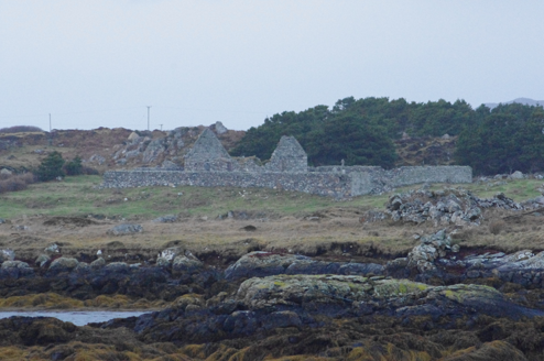 Teampall Cróine [Templecrone]Church/chapel · 1682 yd
Explorer Tom Teampall Cróine [Templecrone] has stood roofless since c.1620, meaning it has spent four centuries staring straight up at the Donegal sky. I reckon the congregation simply gave up on the weather and decided to let the clouds handle the sermon from now on.
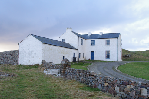 Termon HouseSteward's house · 1.4 mi
Explorer Tom Termon House, built around 1770, has a base that slopes outward, probably to throw rain away from its walls. A raindrop could arrive with a splash and leave with a very offended 'Well, excuse me!' The house overlooks Maghery Bay.
 Strand View BarPub · 1.5 mi
Explorer Tom Strand View Bar probably has a view of the sea and a lot of people staring at it. It's in Donegal, where the wind tries to steal your hat. Go look out the window and feel majestic.
 Lough Aghnish Promontory FortPromontory fort, inland · 2.1 mi
Explorer Tom Lough Aghnish Promontory Fort cuts off a peninsula with a stone wall that has a weird, angled entrance. The base is solid, but the top looks like modern repairs. It’s a bit of a puzzle why they built it exactly there.
 CroaghnamaddyMountain / peak · 2.2 mi
Explorer Tom Craigawaddykeagh in County Donegal is showing off its name like a peacock. If it won the lotto, it’d buy a bigger hat to hide behind. The locals say it’s just a rock with an attitude problem. Stand on the spot and imagine the gossip it's heard. It’s definitely judging your shoes right now.
 Inis Mhic an DoirnIsland · 2.2 mi
Explorer Tom Rutland Island was once pitched as the next big fishing town, and I would have invested every imaginary penny in it. William Burton Conyngham set up the planned settlement between Burtonport and Arranmore in the 1780s, renaming Inis Mhic an Doirn for the Duke of Rutland. There were streets, a customs house, barracks and a sail-and-net factory. Then the herring catches fell, the fishery failed in 1793 and dunes swallowed parts of the village. That is a spectacularly quick lesson in not promising the sea will keep an appointment. The island remained inhabited into the 1960s; houses there are now holiday homes. Arrange a permitted boat and confirm landing and return before visiting, and respect private buildings. Look at the dunes with the lost street plan in mind. Sand is a ruthless town planner.
Hook Point / Pointe an DuáinHeadland · 2.4 miExplorer Tom Hook Point / Pointe an Duáin in County Donegal has a family tree that is mostly made up by its own grandad, who swore it was descended from a Viking longboat. The headland just stands there looking hooked and unbothered while the locals argue about its lineage and its attitude. Go now, before it gets famous.
 O’Donnell’sPub · 2.5 mi
Explorer Tom O’Donnell’s in Burtonport is called Jimmy Johnny’s by locals, which proves names change faster than tides. It would cope on a reality show by gossiping until they drop. Leave nothing but footprints and a bad pun.
Near beachBeach / strand · 3.0 miExplorer Tom Near beach in County Donegal refuses to fall down because it thinks gravity is just a temporary fashion trend that will eventually go out of style. It’s been holding its breath for decades waiting for the earth to stop spinning so it can float away. Perfect detour when the satnav has a meltdown.
 An tÍochtarIsland · 3.4 mi
Explorer Tom An tÍochtar is having a real go at the seagulls today. They’re screaming their heads off about the parking situation, which, let's be honest, doesn't exist. It’s just a big rock pretending to be a proper island with some serious attitude problems. Tell the kids it's a castle. Close enough.
 Cairn on Cnoc an IolairPublicly named cairn · 5.3 mi
Explorer Tom Cairn on Cnoc an Iolair sits on a place that sounds like it’s waiting for a giant eagle to land. Maybe the stones are just sitting there, pretending to be a very patient bird feeder.
 Drumlaghdrid HillMountain / peak · 5.4 mi
Explorer Tom Drumlaghdrid Hill stands in County Donegal with its access details currently unknown. A photograph shows the B7905 road climbing south-eastwards across its flank, six kilometres north of Lettermacaward. It is a bit cheeky for a hill to have such a well-documented road climbing up its side while still keeping its own path a secret!
More islands in County Donegal · All of County Donegal

What do you know about this place?Tap to add a comment or ask a question