
Places near here
Photo credits
- Kevgorman, Wikimedia Commons · CC BY-SA 4.0
- National Inventory of Architectural Heritage
- Oliver Dixon, Geograph · CC BY-SA 2.0
- Wanfried-Dublin, Wikimedia Commons · CC BY 4.0
- Kieran Campbell, Geograph · CC BY-SA 2.0
- Maker named on the Wikimedia Commons picture page · CC BY-SA 2.5
 Church (in ruins)Church · 292 yd
Explorer Tom Church in Relagh Beg would win a county fair for best dressed in ruins. There was a hospital there once, so it knows all about suffering and resilience. Bring a camera and your most suspicious face.
 Grave YardGraveyard · 302 yd
Explorer Tom Graveyard in Relagh Beg is walled off like it's protecting a state secret. The gate has a date on it, but I'd bet good money it's wrong. It's the kind of place that makes a dull Tuesday interesting, trust me.
MoatCastle, motte and bailey · 375 ydExplorer Tom Moat at Relagh Beg is a steep-sided mound where the west side has been quarried away for building materials. The dance held there went too far and broke the bank. Go now, before it gets famous.
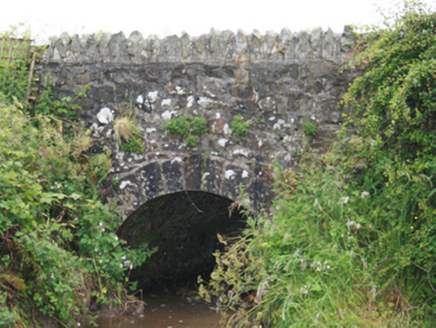 County BridgeBridge · 921 yd
Explorer Tom County Bridge spans the border like it owns both sides, which is very cheeky of a humble stone structure to do. The mother-in-law who designed it definitely added an extra arch just to be difficult. Look up at the fine stonework.
Blackhills LowerMountain / peak · 1.0 miExplorer Tom Blackhills Lower has a shortcut that isn't actually a shortcut but rather a long, confusing detour through the brambles that will test your soul. It’s got that deceptive, 'trust me' energy that leads to more mud than expected. Bring a friend who talks too much and let the place shut them up.
CastleCastle, tower house · 2.4 miExplorer Tom Castle in Newcastle almost got sold as part of a horse deal, which sounds ridiculous but probably happened. It’s ruinous now, meaning it has given up on looking presentable for the neighbors. Best enjoyed with a bag of chips and no plans.
 LoughanleaghForest · 3.1 mi
Explorer Tom Loughanleagh in County Cavan is a forest that got left behind at a party and never quite figured out what it was supposed to be doing there. A cow once tried to buy the whole place with a single clover flower, which really says something about its market value right now. Bring wellies and low expectations, leave delighted.
.jpg/250px-Rantavan-Mullagh_(2).jpg "Photo: Wanfried-Dublin, Wikimedia Commons · CC BY 4.0") Ogham stone (present location) in MullaghOgham stone (present location) · 4.1 mi
Ogham stone (present location) in MullaghOgham stone (present location) · 4.1 miExplorer Tom Ogham stone in Mullagh is living its best life at St Kieran's Heritage Centre, playing dress-up as a headstone while pretending it hasn't moved house three times yet. It’s basically the guy who shows up to your wedding in a tuxedo but still wears his running shoes underneath. Stick around for the light changing, it's a show.
 Brothers GravesVisitor information · 4.2 mi
Explorer Tom Brothers Graves is where seven Marist brothers kicked the bucket after decades of quiet prayer and probably way too much tea. They’re buried right there in Bailieborough Demesne, looking smug about their eternal rest. I bet they’re still judging your posture from under the soil, so stand up straight or else.
 Fair of MuffVisitor information · 4.2 mi
Explorer Tom Fair of Muff in County Cavan would order a mountain of chips and a pint if it could walk into a chippy. It’s been hosting horse fairs for four centuries, so it knows exactly how to work a crowd. Perfect place to be dramatically windswept while pretending you planned the hairdo.
 EnaghMountain / peak · 4.3 mi
Explorer Tom Enagh in County Cavan has an imaginary twin across the sea who sends postcards every Tuesday claiming it’s taller. Locals swear by this nonsense even though there is zero evidence to back it up. Go on, count the windows and get it wrong like I did.
 Sessile Oak5.8 mi
Explorer Tom Sessile Oak in County Cavan is playing hide-and-seek with me. I bet it’s hiding because it knows you’re not bringing a ladder. A handy spot to stretch your legs and your imagination, even if the leaves are judging your outfit.
More archaeology and monuments in County Cavan · All of County Cavan

What do you know about this place?Tap to add a comment or ask a question