
Places near here
Photo credits
- Kevgorman, Wikimedia Commons · CC BY-SA 4.0
- National Inventory of Architectural Heritage
- Oliver Dixon, Geograph · CC BY-SA 2.0
- Wanfried-Dublin, Wikimedia Commons · CC BY 4.0
- Kieran Campbell, Geograph · CC BY-SA 2.0
- Maker named on the Wikimedia Commons picture page · CC BY-SA 2.5
 Church (in ruins)Church · 61 yd
Explorer Tom Church in Relagh Beg would win a county fair for best dressed in ruins. There was a hospital there once, so it knows all about suffering and resilience. Bring a camera and your most suspicious face.
 Grave YardGraveyard · 70 yd
Explorer Tom Graveyard in Relagh Beg is walled off like it's protecting a state secret. The gate has a date on it, but I'd bet good money it's wrong. It's the kind of place that makes a dull Tuesday interesting, trust me.
MoatCastle, motte and bailey · 99 ydExplorer Tom Moat at Relagh Beg is a steep-sided mound where the west side has been quarried away for building materials. The dance held there went too far and broke the bank. Go now, before it gets famous.
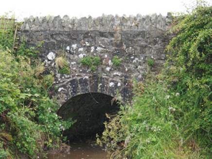 County BridgeBridge · 826 yd
Explorer Tom County Bridge spans the border between Cavan and Meath with a rubble-stone arch. It’s tiny but proud of its position. Say hello to your younger self if you see him crossing over.
Blackhills LowerMountain / peak · 1.1 miExplorer Tom Blackhills Lower is part of the Blackhills range in County Cavan, offering a lower starting point for hikers.
CastleCastle, tower house · 2.5 miExplorer Tom Castle in Newcastle almost got sold as part of a horse deal, which sounds ridiculous but probably happened. It’s ruinous now, meaning it has given up on looking presentable for the neighbors. Best enjoyed with a bag of chips and no plans.
 LoughanleaghForest · 3.2 mi
Explorer Tom Loughanleagh has waymarked paths, so you won’t get lost, but I bet there are plenty of shortcuts for those who know where to look.
.jpg/250px-Rantavan-Mullagh_(2).jpg "Photo: Wanfried-Dublin, Wikimedia Commons · CC BY 4.0") Ogham stone (present location) in MullaghOgham stone (present location) · 4.1 mi
Ogham stone (present location) in MullaghOgham stone (present location) · 4.1 miExplorer Tom Ogham stone in Mullagh is living its best life at St Kieran's Heritage Centre, playing dress-up as a headstone while pretending it hasn't moved house three times yet. It’s basically the guy who shows up to your wedding in a tuxedo but still wears his running shoes underneath. Stick around for the light changing, it's a show.
 EnaghMountain / peak · 4.1 mi
Explorer Tom Near Enagh in County Cavan, the air is fresh, and the local mill history adds a touch of intrigue.
 Brothers GravesVisitor information · 4.2 mi
Explorer Tom Brothers Graves holds a touching memory, marking seven Marist brothers who lived long lives in this community.
 Fair of MuffVisitor information · 4.4 mi
Explorer Tom Check out the Fair of Muff sign, which notes a sculpture commemorating the Horse Fair held here for four centuries in County Cavan.
 Sessile Oak5.7 mi
Explorer Tom Sessile Oak in County Cavan is playing hide-and-seek with me. I bet it’s hiding because it knows you’re not bringing a ladder. A handy spot to stretch your legs and your imagination, even if the leaves are judging your outfit.
More archaeology and monuments in County Cavan · All of County Cavan

What do you know about this place?Tap to add a comment or ask a question