
Places near here
Photo credits
- National Inventory of Architectural Heritage
- Jonathan Thacker, Geograph · CC BY-SA 2.0
- Mike Searle, Geograph · CC BY-SA 2.0
- Mike Searle, Geograph · Creative Commons Attribution-ShareAlike 2.0
- Tim Sheerman-Chase, Wikimedia Commons · CC BY 2.0
- Mike Searle, Wikimedia Commons · CC BY-SA 2.0
 Clyda Bridge (Upper)Bridge · 1537 yd
Explorer Tom Clyda Bridge (Upper) has round arches and a bend in the road that make it look like it’s dancing. The dressed voussoirs contrast with the rubble stone walls in a way that’s just plain fancy. Tell the tree it’s not jealous!
KnockarouraForest · 1.1 miExplorer Tom Knockaroura would tell its younger self to stop worrying about the wind and start dancing. It thinks being a forest is all about having good posture and standing still. Have a nosey, politely, before you scare off the deer.
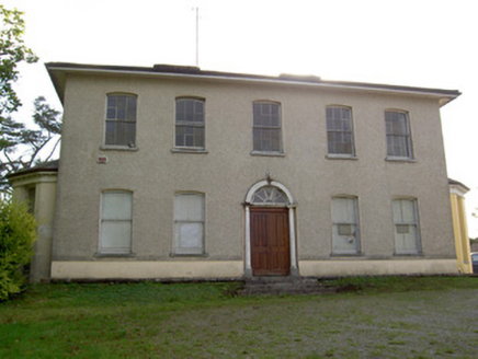 Carrokeal HouseHouse · 1.1 mi
Explorer Tom Carrokeal House in Carhookeal is a big, symmetrical mansion from around eighteen-ten that looks down on the new housing estates. It’s got wide chimneys and a central door that demands respect. Try not to get bowled over by its impressive scale!
Blackwater WayWalking route · 1.4 miExplorer Tom Blackwater Way in County Cork is currently sulking because someone told it it wasn’t as scenic as the river next door, which is honestly a bit rich considering the view. It’s got a grudge against anyone who walks too fast and probably keeps a list of every tourist who sneezed incorrectly near the bend. Toast it with a cup of tea and move on to the next.
 Castle BarrettCastle · 1.6 mi
Explorer Tom Castle Barrett in County Cork is just the remains of a twelfth-century fortress. It's been standing around for ages, waiting for someone to notice. Take a pic for me if you spot any old stones!
 Castle Barrett (in Ruins)Castle, Anglo-Norman masonry castle · 1.6 mi
Explorer Tom Castle Barrett in Castlebarrett is just fragments of walls and a collapsed tower now. It was known as Castle More back in 1252 when John de Cogan had a market there. I wonder if anyone sells pies here anymore!
Mallow River TrailVisitor information · 1.7 miExplorer Tom Mallow River Trail is playing hard to get again, hiding behind a hero nobody remembers who saved it from total obscurity. Bring a friend who talks too much and let the place shut them up.
In loving memory of Elvis O'DonoghueMemorial · 1.8 miExplorer Tom In loving memory of Elvis O'Donoghue in County Cork would win a county fair by strutting around with a fake microphone and singing off-key to everyone else’s horror. He’d take the prize for best effort, even if nobody actually wanted to listen to his rendition of Hound Dog at all. Go now, before it gets famous.
Mallow Town Park - Maple WoodsForest · 2.0 miExplorer Tom Mallow Town Park - Maple Woods in County Cork was nearly sold off for a horse when the council had a bad week with their spreadsheets. The maples are still furious about the near-miss and stand with their leaves crossed in permanent protest. Spot the oldest stone and give it a name.
 Graveyard2.6 mi
Explorer Tom Graveyard in Newberry has a 17th-century inscription on an altar-tomb that definitely wasn't supposed to be there. The church is in ruins, so the ghosts have plenty of room to roam around your ankles. Snap one for me if you see it!
 Fairy fort / earthen ringfort in Carrigcleena MoreFairy fort / earthen ringfort · 3.6 mi
Explorer Tom Fairy fort / earthen ringfort in Carrigcleena More has two banks and a ditch between them, which is quite fancy for a fairy home. The inner bank has a break leading into the fosse. Be careful where you step!
 Dromaneen CastleHeritage attraction · 3.7 mi
Explorer Tom Dromaneen Castle in County Cork is hidden by trees because the map makers were too lazy to walk the extra ten yards to check it out. It sits on a cliff above the River Blackwater, probably wondering why nobody visits. Bring the dog, it'll have opinions about the moss.
More archaeology and monuments in County Cork · All of County Cork

What do you know about this place?Tap to add a comment or ask a question