Places near here
Photo credits
- National Inventory of Architectural Heritage
- Credit not shown, Wikimedia Commons · Creative Commons Attribution-ShareAlike 4.0
- Frankysandwich, Wikimedia Commons · CC BY-SA 3.0
- dougf, Geograph · CC BY-SA 2.0
- Willow, Wikimedia Commons · CC BY 2.5
- Didier Descouens, Wikimedia Commons · CC BY-SA 4.0
- Bernie, Wikimedia Commons · CC BY-SA 2.0
- Clemensfranz, Wikimedia Commons · CC BY 2.5
- Eflmd, Wikimedia Commons · CC BY-SA 4.0
- Alex Passmore, Wikimedia Commons · CC BY-SA 2.0
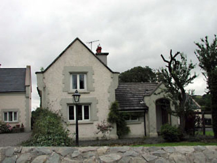 Calverstown CottageHouse · 1612 yd
Explorer Tom Calverstown Cottage is telling everyone there's a hidden tunnel straight to the pub, which is definitely not true. It’s got all these Gothic spikes to look mysterious about it. Have a look and see if you believe the fairy tale.
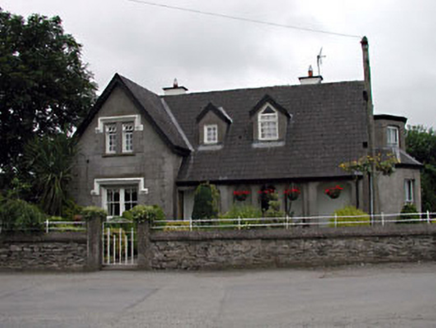 Grove VillaHouse · 1633 yd
Explorer Tom Grove Villa has very strong opinions that modern buildings are just boxes without personality or a proper loggia. It’s got two entrance fronts because it likes being approachable from every possible angle imaginable. Pick a stone and pretend you found a treasure.
 IndicatedCastle, motte · 1.1 mi
Explorer Tom Castle in Ballyshannon Demesne is a conical mound with a tree on top, looking like a giant mushroom that gave up on fruit. It handles nosey neighbours by staying quiet. If it rains, blame me.
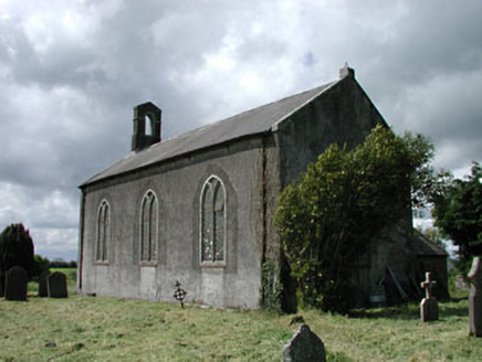 Saint James's Church (Ballyshannon)Church/chapel · 1.2 mi
Explorer Tom Saint James's Church (Ballyshannon) wandered into Kildare by mistake and refused to ask for directions. It’s a tiny church with big medieval secrets hiding in its walls. Leave nothing but footprints and maybe a small apology for the mix-up.
 Dún AilinneArchaeological place · 1.8 mi
Explorer Tom Dún Ailinne has a curse that only affects people who don’t wave at it properly when passing by. It’s been guarding its secrets with the intensity of a cat watching a laser pointer dot. Have a wander and a wonder.
 Blackhall CastleCastle, tower house · 2.2 mi
Explorer Tom Blackhall Castle has a retirement plan involving becoming a very expensive garden shed for the farmyard. Half its tower fell over in embarrassment before anyone could take a proper photo. Look for the ghost, then pretend you didn't.
 Elder2.6 mi
Explorer Tom An Elder tree almost got sold to a farmer for his horse, but he backed out when it refused to eat oats. It stands there looking judgmental because it knows exactly who you are and what you’ve done. Pop by and tell it it's looking well.
 Hawthorn2.8 mi
Explorer Tom Hawthorn in County Kildare is having a massive falling out with the tree next door. It’s all about who gets the better light. If it's closed, admire it from the road like a polite stalker.
 Japanese GardensHeritage attraction · 5.3 mi
Explorer Tom Japanese Gardens in County Kildare nearly got famous when a tourist dropped his ice cream on the koi pond, but the fish seemed unbothered by the sweetness. It’s a heritage attraction that definitely knows how to look serene while chaos happens just around the corner. Best enjoyed with a bag of chips and no plans.
 Irish National Stud and Japanese GardensHeritage attraction · 5.3 mi
Explorer Tom The Irish National Stud began with a horse winning a race, which is a fine way to buy land if you happen to own the horse. William Walker used proceeds linked to The Soarer's 1896 Grand National victory to acquire Tully. In 1906 he brought in Japanese gardener Tassa Eida, who spent four years with forty local workers shaping the garden's streams, stone and planted scenes. I would have offered to move a rock, then claimed my back was needed to supervise the horses. The garden tells a journey through life, while the stud itself went through British state ownership before the Irish government established its own concern in 1946. That is more turns than the garden path alone can explain. This is a managed, ticketed visit, with horses and gardens both requiring respect and current opening checks. Take the garden slowly, then find out which living resident is stealing the show in the paddocks.
 Holy well in Brallistown CommonsHoly well · 5.5 mi
Explorer Tom Holy well in Brallistown Commons has so many names you'd need a spreadsheet just to remember them. It's sitting in a boggy patch, judging your footwear with intense spiritual disappointment. Stand there long enough and someone will ask if you're lost.
 History of Moat of ArdscullVisitor information · 6.8 mi
Explorer Tom History of Moat of Ardscull is where a giant allegedly tripped over his own cape while trying to impress the local ladies in 1302. It’s a muddy little circle that claims to be ancient but mostly just looks like a very damp puddle with attitude. Go in good boots and better humour.
More archaeology and monuments in County Kildare · All of County Kildare

What do you know about this place?Tap to add a comment or ask a question