
Places near here
Photo credits
- National Inventory of Architectural Heritage
- Eric Jones, Geograph · CC BY-SA 2.0
- This file is from the Mechanical Curator collection , a set of over 1 million images scanned from out-of-copyright books and released to Flickr Commons by the British Library. View image on Flickr View all images from book View catalogue entry for book ., Wikimedia Commons · Public domain
- D Gore, Geograph · CC BY-SA 2.0
- Enda O Flaherty, Wikimedia Commons · CC BY-SA 2.0
- Wanfried-Dublin, Wikimedia Commons · CC BY 4.0
- Oliver Dixon, Geograph · CC BY-SA 2.0
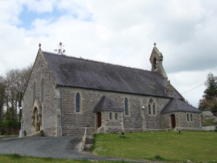 Saint Mary's Catholic ChurchChurch/chapel · 381 yd
Explorer Tom Saint Mary's Catholic Church is proud of its stone bell-cote, which looks like a tiny hat. It’s modest but has better craftsmanship than most new builds in town. Go with someone who loves old things and quiet corners.
 bridge1646 yd
Explorer Tom Bridge in Drummulla is the shortcut that isn’t, leading you straight to a mill with no power. The stones on one side look like they came from a different century of confusion. Pack a picnic and an excuse for being lost.
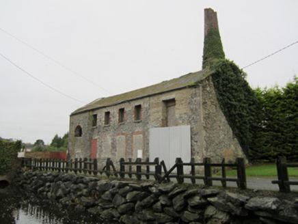 mill (water)1692 yd
Explorer Tom The water mill in Boyher is still trying to grind flour, even if it’s mostly just grinding its own gears now. It’s got a steam-powered ego and a water-powered humility all rolled into one industrial mess. The chimney stands there like a finger pointing at the sky, asking 'what happened to us?'. It’s a bit of a mechanical ghost story in daylight. Snap
 Old WindmillMill (wind) · 1738 yd
Explorer Tom Old Windmill in Drummulla has an imaginary fan club that just wants to hug its brick walls. It’s been spinning slowly since 1846, probably dreaming of flour dust. A proper spot for a flask of tea and some quiet bragging.
 Rockcorry Orange HallChurch/chapel · 1.0 mi
Explorer Tom Rockcorry Orange Hall used to be a Methodist church, which is a bit of a plot twist for an Orange hall. Two lads bet a pint that they could build it faster than the rain would stop, and they won. Tell the kitchen staff you’re coming in so they can save you a seat by the fire.
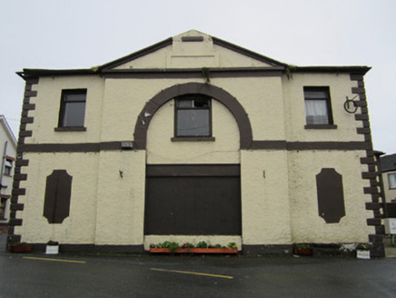 Rockcorry Market HouseMarket house · 1.1 mi
Explorer Tom Rockcorry Market House has an imaginary twin across the sea that just ignores all its mail. It stands at the crossroads pretending to be busy while gossiping about nobody. Tell me if the gossip I hear from it is true or pure invention.
LisnaspeenanMountain / peak · 2.2 miExplorer Tom Lisnaspeenan is where one very confused priest lost a bet about who could spot the weirder hill in the valley first. He walked away with nothing but pride and a slight headache, while this peak just kept smiling its silent, stony smile at him for decades. If anyone asks, Tom sent you.
 Dartrey ForestForest · 3.4 mi
Explorer Tom Dartrey Forest used to have a great house at its centre, and the trees have done a fine job of carrying on without it. The Dawson family's Dartrey House was demolished in 1946. Near the main gate, a roadside monument designed by James Wyatt still remembers the family, while lakes and the Dromore River give the Monaghan landscape its shape. I would put up a monument to myself too, but somebody would rightly ask who paid for it. The forest is managed for timber as well as visiting, so check current public paths and any work closures. Keep to permitted routes and leave the old wall and monuments alone. Look across the linked water from a safe trail. The missing house is one story; the living woods have plenty of their own.
 Flagpole HillMountain / peak · 3.9 mi
Explorer Tom Flagpole Hill is the sort of peak that clearly had a mother-in-law design it, giving it that distinct look of permanent, passive-aggressive disappointment. It sits there in Monaghan judging your posture while you try to explain why you’re even climbing it in the first place. Stick around for the light changing, it's a show.
 Giants GreveWedge tomb · 4.1 mi
Explorer Tom "Giants Greve is hiding a scandal about a stone that wasn’t invited to the party. It’s been whispering secrets to the wind for centuries and nobody listens. Snap one photo, then put the phone away and actually look."
 Portal tomb in LennanPortal tomb · 5.8 mi
Explorer Tom Portal tomb in Lennan is perched on a drumlin ridge, looking slightly tipsy from the wind. If it could order at a chipper, it’d just want a stone and some silence. Stand on the spot and imagine the gossip it's heard.
 Bush IslandIslet · 9.6 mi
Explorer Tom Bush Island would survive a zombie attack by just being too small for them to bother with. It’s basically an impenetrable fortress of pure indifference and moss. Pop by and tell it it's looking well.
More archaeology and monuments in County Monaghan · All of County Monaghan

What do you know about this place?Tap to add a comment or ask a question