DDiscover AloneMapAbout

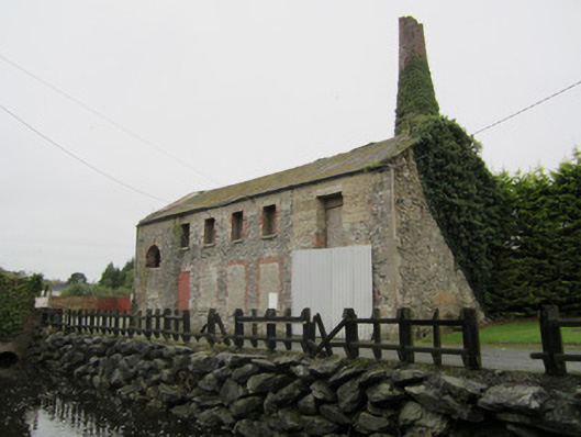
Mill in Boyher

Mill (water)
Mill in Boyher
Photo: National Inventory of Architectural Heritage · Report the wrong picture

What is recorded here

Detached six-bay, two-storey water and steam-powered corn mill, built c.1850. Now in use as store. Replacement pitched corrugated-asbestos roof with cement verges, galvanised metal gutters and downpipes. Random rubble coursed stone walls, with finely dressed quoins. Segmental-headed windows to ground floor, brick…

Read the whole record
Detached six-bay, two-storey water and steam-powered corn mill, built c.1850. Now in use as store. Replacement pitched corrugated-asbestos roof with cement verges, galvanised metal gutters and downpipes. Random rubble coursed stone walls, with finely dressed quoins. Segmental-headed windows to ground floor, brick surrounds,stone sills, infilled with concrete blocks and stone. Segmental-headed opening, having brick surrounds, now blocked up. North gable has possible opening for auxiliary drive. Square-headed openings to first floor, with brick surrounds and stone sills, boarded up. Northernmost opening converted to first floor loading door. Single brick-trimmed semi-circular-headed opening rising through both floors at south end of front elevation, partially blocked up. Square-headed door openings with inserted concrete lintels, metal-frame corrugated-sheet metal clad sliding and side-hung doors. Ruinous truncated remains of corn mill partly project into river to south-east, with brick-trimmed semi-circular opening at water level on north gable. Embanked head race and freestanding square-profile brick chimney to west of mill. Terrace of eight single-storey mill workers' houses located to north.
This mill and chimney form part of a group of interesting industrial structures associated with Rockcorry Mills. Although the milling complex only partly survives, it is of interest in having been powered by water and steam power, manifest in the head race, engine/boiler house and chimney. The latter is also a distinctive local landmark, as is the roadside terrace of houses. These structures serve as physical reminders of the industrial and social history of Rockcorry.

From the Buildings of Ireland (National Inventory of Architectural Heritage) record 41306005

This does not grant access. Most recorded buildings are privately owned; view them only from public ground unless the owner allows entry.

Recorded change of use
Originally mill (water); recorded by the architectural inventory as outbuilding
What do you know about this place?Tap to add a comment or ask a question

What you write will be public.

Places near here

Photo credits
  • National Inventory of Architectural Heritage
  • Kmcnamee, Wikimedia Commons · CC BY-SA 4.0
  • Eric Jones, Geograph · CC BY-SA 2.0
  • This file is from the Mechanical Curator collection , a set of over 1 million images scanned from out-of-copyright books and released to Flickr Commons by the British Library. View image on Flickr View all images from book View catalogue entry for book ., Wikimedia Commons · Public domain
  • D Gore, Geograph · CC BY-SA 2.0
  • Enda O Flaherty, Wikimedia Commons · CC BY-SA 2.0
  • Wanfried-Dublin, Wikimedia Commons · CC BY 4.0
  • Drumhowan GAA club; individual photographer not named, drumhowan.gaa.ie
  • Oliver Dixon, Geograph · CC BY-SA 2.0
bridge52 yd

Explorer Tom Bridge in Drummulla is the shortcut that isn’t, leading you straight to a mill with no power. The stones on one side…

Páirc Muire, RockcorryGAA ground · 144 ydRockcorry Orange HallChurch/chapel · 146 yd

Explorer Tom Rockcorry Orange Hall used to be a Methodist church, which is a bit of a plot twist for an Orange hall. Two lads bet a…
almshouse175 yd

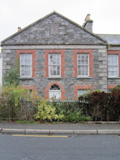
Explorer Tom Almshouse in Boyher number two is basically its neighbour's twin brother with slightly better posture and a deeper sigh…

LisnaspeenanMountain / peak · 1.3 mi

Explorer Tom Lisnaspeenan is where one very confused priest lost a bet about who could spot the weirder hill in the valley first. He…

Back WoodForest · 2.0 mi

Explorer Tom Back Wood is governed by a strict superstition that says if you step on a dry leaf in autumn, you owe the forest a song…

Dartrey ForestForest · 2.4 mi

Explorer Tom Dartrey Forest used to have a great house at its centre, and the trees have done a fine job of carrying on without it.…

Flagpole HillMountain / peak · 2.9 mi

Explorer Tom Flagpole Hill is the sort of peak that clearly had a mother-in-law design it, giving it that distinct look of…

Giants GreveWedge tomb · 4.7 mi

Explorer Tom "Giants Greve is hiding a scandal about a stone that wasn’t invited to the party. It’s been whispering secrets to the…

Portal tomb in LennanPortal tomb · 6.6 mi

Explorer Tom Portal tomb in Lennan is perched on a drumlin ridge, looking slightly tipsy from the wind. If it could order at a…

Páirc Mhic Eoin, Drumhowan GeraldinesGAA ground · 7.8 miBush IslandIslet · 9.2 mi

Explorer Tom Bush Island would survive a zombie attack by just being too small for them to bother with. It’s basically an…

More historic places in County Monaghan · All of County Monaghan

Add to this placeAdd a picture Add a detailed tip Add a story

Explore the map1,095,054 places to discover

Next place · or swipebridge