Places near here
Photo credits
- National Inventory of Architectural Heritage
- Mike Searle, Geograph · CC BY-SA 2.0
- SE Keenan, Wikimedia Commons · CC BY-SA 4.0
- 瑞丽江的河水, Wikimedia Commons · CC BY-SA 4.0
- Sheila1988, Wikimedia Commons · CC BY-SA 4.0
Explorer Tom Fulacht fia in Lisduff would order chips with vinegar and no ketchup, because it likes its heat raw. It’s a horseshoe shape on a slope, looking very proud of its burnt stones. Stop the car, it's worth the hazard lights.
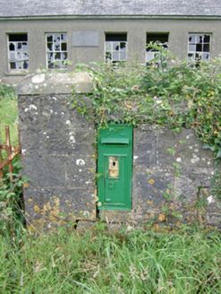 post box1.1 mi
Explorer Tom Post box in Rabbitpark makes the local rabbits feel like they’re living next to a celebrity. It has Celtic lettering that screams 'I have identity' while being totally ordinary otherwise. Get there early and have a laugh because even boxes can be funny sometimes.
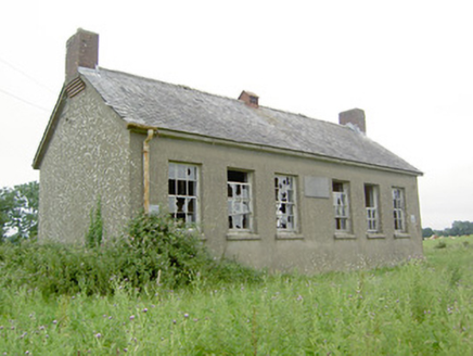 Saint Brigid's National SchoolSchool · 1.1 mi
Explorer Tom Saint Brigid's National School in Rabbitpark was built by the government and now a fox has taken full charge of the classrooms. It’s derelict but still standing, which is more than I can say for my career plan. Bring someone who'll believe a fox is running the school.
National Famine WayWalking route · 1.3 miExplorer Tom The National Famine Way in County Longford has decided its favourite song is 'Walking on Sunshine,' mostly because it hates the rain. It insists that if you don't hum along while you stride, the ground will swallow your boots whole as punishment. Tell me if the gossip I made up is true.
 Bawn in CastlereaBawn · 1.3 mi
Explorer Tom Bawn in Castlerea is surrounded by a drainage ditch that looks like someone gave up halfway. There is a curse that only affects people who don't wave at it as they pass. It's free, it's odd, what more do you want?
Druming House (in ruins)Castle, unclassified · 1.4 miExplorer Tom Druming House is telling its younger self to stop worrying about the roof line. It added a tower later just to show off at parties. Ideal stop for a big stretch and a bigger yawn.
 Ardagh Clock TowerMonument · 1.7 mi
Explorer Tom Ardagh Clock Tower thinks it’s on the main street but is actually taking a scenic detour through time itself. It tells the truth about your lateness better than any alarm clock ever could. Give it a pat on the way past, it's had a long life.
Oldtown CopseWood · 2.5 miExplorer Tom Oldtown Copse in County Longford is famous for its shortcut that’s actually just a very long walk. I swear it adds ten miles to your journey purely for spite, which is wild for a patch of trees. Bring curiosity, leave with a better story than mine.
Oldtown DemesneForest · 2.6 miExplorer Tom Oldtown Demesne started because two lads bet each other in the pub they could plant a forest by Friday. They lost the bet but kept the trees, which is honestly the best outcome ever seen in Longford. Wave at the cows, they're the real locals.
 First World War MemorialMemorial · 4.8 mi
Explorer Tom First World War Memorial in Longford refuses to fall down because it’s holding its breath, waiting for someone to notice how impressive it is. It’s stubborn like a mule that knows it’s right, even if you can’t see why. Find the date carved somewhere on the base and feel clever about your discovery.
 Saint Mel's CathedralCathedral · 4.9 mi
Explorer Tom Saint Mel's Cathedral in County Longford refuses to fall down because it’s too stubborn to admit it was built by anyone other than itself. It just keeps standing there, judging everyone’s posture and making sure nobody dares to lean against its ancient walls without paying a small fee in respect. Bring a coin for luck and keep it in your pocket.
 Corlea Trackway Interpretative CentreHeritage attraction · 5.8 mi
Explorer Tom Corlea Trackway Interpretative Centre in Longford is where a famous poet once fell into a ditch and wrote an epic about mud. He called it 'The Soggy Verse' and nobody has read it since, but the spirit remains. Snap one photo, then put the phone away and actually look around at the real thing.
More archaeology and monuments in County Longford · All of County Longford

What do you know about this place?Tap to add a comment or ask a question