Places near here
Photo credits
- National Inventory of Architectural Heritage
- Stephan van Helden, Wikimedia Commons · CC BY-SA 4.0
- Malene Thyssen, Wikimedia Commons · CC BY-SA 3.0
- Kieran Campbell, Geograph · CC BY-SA 2.0
- Kieran Campbell, Geograph · Creative Commons Attribution-ShareAlike 2.0
- Eric Jones, Geograph · CC BY-SA 2.0
 Carrickmacross Railway StationStore/warehouse · 375 yd
Explorer Tom Carrickmacross Railway Station goods shed ended up here because the mapmakers got their left and right confused. It’s just sitting there looking lost among the water towers. Bring a jacket, it’s never actually warm in that drafty old place.
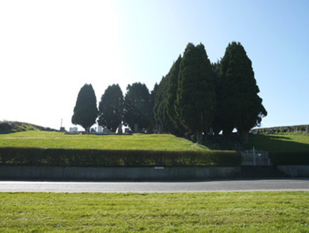 God's AcreGraveyard/cemetery · 379 yd
Explorer Tom God's Acre is perched up high like God himself wanted a balcony view of Carrickmacross town before he left for the big one. It’s got yew trees flanking the paths, which is lovely and orderly, provided you don’t mind being watched by a lot of very static greenery. The whole place has a striking visual impact from the approach, so you can’t miss it even if
 Horse-chestnut1.1 mi
Explorer Tom Horse-chestnut in County Monaghan was likely planted after a bargain where someone promised to water it if it grew tall enough to hide their garden from neighbors. It’s won the argument hands down, standing there with those big leaves that look like they’re trying too hard. Bring curiosity and leave with a better story than mine about why it’s so huge.
 European Beech1.3 mi
Explorer Tom This European Beech handles nosy neighbours by dropping exactly one leaf on their heads every morning as a warning. It’s subtle but deadly effective. Tell the next person you meet it's haunted. It might be.
 Mannan CastleArchaeological place · 2.5 mi
Explorer Tom Mannan Castle is deeply suspicious of the postman because it knows that every delivery brings more questions about why it’s still standing there looking so dignified and mysterious. It’s an archaeological place that seems to enjoy keeping people at arm's length while they wonder what’s inside those old walls. Bring a flask and pretend you own the place.
Mannan Castle (in ruins)Castle, Anglo-Norman masonry castle · 2.5 miExplorer Tom Mannan Castle in Donaghmoyne would introduce itself as a very serious Anglo-Norman masonry castle that just happens to be sitting on a ridge and looking rather smug about it. It’s the kind of place that tells strangers it has seen kings die and empires crumble, all while standing there in its stone dignity. The Pipards built it in the
 IndicatedGraveyard · 9.5 mi
Explorer Tom Graveyard in Killincoole has one stubborn bird that refuses to leave despite the restoration scheme. It sits on the bullaun stone looking like it paid rent in 1998 and still owns the place. Perfect place to be dramatically windswept.
 Promontory fortPromontory fort, inland · 9.6 mi
Explorer Tom Promontory fort in Slieve has had so many former names it’s lost count and just goes by 'that hill.' It’s an oval area on a ridge and thinks it’s mysterious. Stand back, squint, and it looks like a castle.
 Ballsmill Amenity LandPicnic place · 11 mi
Explorer Tom Ballsmill Amenity Land in County Armagh is where the wind has a personal grudge against everyone who brings a frisbee, probably because it lost a bet to the river last century. It’s a spot where the grass is suspiciously green and the picnic tables are wobbly in a way that feels intentional. Find the wonkiest bit and send it to your group chat.
 Irish Hunger StrikersMemorial · 11 mi
Explorer Tom Irish Hunger Strikers memorial at New Roads Crossroads is a rock that stands firm because it refuses to take the shortcut of being ignored. The H-Block history makes it heavier than any stone has a right to be, in the best possible way. Give it a pat on the way past, it's had a long life.
 Graveyard in StickillinGraveyard · 12 mi
Explorer Tom Stickillin’s medieval church had stained glass found during conservation work, which is fancy for ruins. If it had to teach history, it would use flashcards and bad puns. Great spot to propose. Or at least to propose lunch.
 Mass Rock Loop TrailWalking route · 12 mi
Explorer Tom Mass Rock Loop Trail is named after a rock that apparently held a mass, which sounds like a lot of pressure for a piece of stone. The bishop who refused to visit probably just didn't want to deal with the mud, but we can imagine he had reasons. Have a look and decide if I was lying about the holy vibes.
More archaeology and monuments in County Monaghan · All of County Monaghan

What do you know about this place?Tap to add a comment or ask a question