What is recorded here
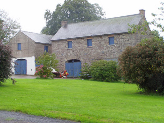
Two ranges of abandoned farm buildings and residence, on S side of Kilworth hills. Indicated on 1842 OS 6-inch map as two ranges of buildings, on N and S side of yard, and named 'nursery'. Random-rubble sandstone construction with ashlar detail. Two-storey N range (long axis E-W), has central projecting 3-storey 2-bay block with wide ground floor arches, upper storeys weatherslated. Residential house at W end of N range with ornate weatherslating on W gable, inscribed with date "1834". Two-storey S range (long axis E-W) has series of fine sandstone arches; first floor arched opes on S side are at external ground level. Yard to S enclosed by walls, divided into two. Yard between N and S ranges enclosed by walls on E and W side, tall arched entrance in roadside wall to W. According to local information, it was 'home farm' for Cooke-Collis of Castle Cooke (see 14345, 14867), c. 1.5km to NW, using special modern farming techniques including S range cow byre where cattle could be fed from 1st-floor level.
The above description is derived from the published 'Archaeological Inventory of County Cork. Volume 4: North Cork' (Dublin: Stationery Office, 2000). In certain instances the entries have been revised and updated in the light of recent research.
Date of upload/revision: 14 January 2009
The monument record does not grant public access. Check the route and ask the landowner before entering private land.
- What survives
- Recorded monument
Places near here
 Castle (in Ruins)Castle, tower house · 1313 yd
 Castle Cookeoutbuilding · 1574 yd
 Castle Cooke (in Ruins)Country house · 1615 yd
 Tobernahulla WellHoly well · 1.4 mi
 Saint Micheal's Holy WellSpring · 1.4 mi
 Leitrim Castle (in Ruins)Castle, Anglo-Norman masonry castle · 1.9 mi
 Fulacht fia in CastlecookeFulacht fia · 1.9 mi
 Natural heritage of CoolagowanVisitor information · 3.2 mi
 Life Space ParkPicnic place · 3.4 mi
 Strawhall WoodForest · 5.3 mi
 Kent BridgeMemorial · 5.4 mi
 FlagCave · 5.4 mi