What is recorded here
From the National Monuments Service (Archaeological Survey of Ireland) record DU011-057002
Places near here
Photo credits
- National Inventory of Architectural Heritage
- Cg.wiki, Wikimedia Commons · CC BY-SA 4.0
- Mike Searle, Wikimedia Commons · CC BY-SA 2.0
- Kieran Campbell, Geograph · CC BY-SA 2.0
- Harold Strong, Geograph · CC BY-SA 2.0
 Graveyard in KillosseryGraveyard · 35 yd
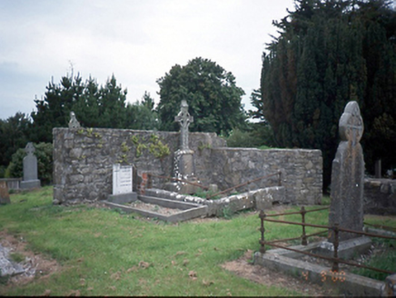 graveyard/cemetery44 yd
Explorer Tom Killossery graveyard has cut-stone markers from 1725 and a church ruin that’s basically just walls now. It’s quiet, so try not to make too much noise or you’ll scare off the local wildlife. Snap the ruins and tell me what they look like!
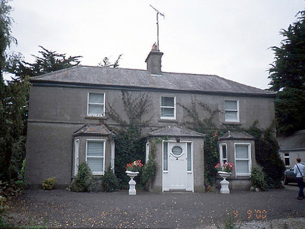 farm house153 yd
Explorer Tom Farm house in Rowlestown West is showing off those bow windows like they’re fashion statements. Built c.1890, it’s got a stable yard and some old cottages too. It’s basically a time capsule with extra steps.
Freedagh MoatCastle, motte · 1.9 miExplorer Tom Freedagh Moat sits on a steep ridge, with part of its earthwork incorporated into a field boundary extending northwest to southeast.
Wooly Ward's FarmHeritage attraction · 2.1 miSt Cronans WellSpring · 3.0 mi Glasmore Abbey (in ruins)Structure · 3.1 mi
Explorer Tom Glasmore Abbey | Mooretown’s square building is 'enigmatic' and sits right inside a modern housing estate. It must be the quietest resident in Cianlea, just watching the bins go out.
 IndicatedFish-pond · 3.2 mi
Explorer Tom Fish-pond in Brackenstown is actually a canal from the early eighteenth century, which is a bit cheeky of them to call it a pond. It’s used for horse riding now, so watch out for hooves and muddy boots.
AshbourneMemorial · 3.3 mi.jpg/250px-Castles_of_Leinster-_Dunsoghly,_Co._Dublin_(geograph_2496350).jpg "Photo: Mike Searle, Wikimedia Commons · CC BY-SA 2.0") CastleCastle, tower house · 4.3 mi
CastleCastle, tower house · 4.3 miExplorer Tom Dunsoghly Castle's four corner towers rise over a farmyard, and I can almost hear the Plunkett family echoing through that barrel-vaulted chamber.
 Hollywood GreatMountain / peak · 5.2 mi
 TyrrelstownWood · 6.2 mi
More historic places in County Dublin · All of County Dublin
What do you know about this place?Tap to add a comment or ask a question