Places near here
Photo credits
- National Inventory of Architectural Heritage
- Jonathan Billinger, Wikimedia Commons · CC BY-SA 2.5
- Kenneth Allen, Geograph · CC BY-SA 2.0
- abdallahh from Montréal, Canada, Wikimedia Commons · CC BY 2.0
- Allie_Caulfield from Germany, Wikimedia Commons · CC BY 2.0
- Kieran Campbell, Geograph · Creative Commons Attribution-ShareAlike 2.0
- Andreas F. Borchert, Wikimedia Commons · CC BY-SA 4.0
- Simonchadwick1023, Wikimedia Commons · CC BY-SA 4.0
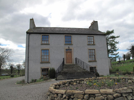 Kilcorran HouseHouse · 308 yd
Explorer Tom Kilcorran House in Kilcorran is showing off its piano nobile floor like it’s still expecting guests to arrive for a grand ball that ended decades ago. The windows have been swapped out for replicas, which feels a bit like wearing a costume to a funeral of the original building's soul. Those sandstone surrounds are trying hard to look better than they actually do, so just appreciate the splayed st
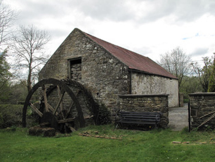 Drummans MillMill (water) · 1.7 mi
Explorer Tom Drummans Mill has a fierce feud with the rain because it keeps trying to get in and mess up the grinding stones. It used to grind oats until shops started selling them in packets. Grand place for a sulk or a snog
 Attack on Derryard checkpointTerrorist attack · 1.8 mi
Explorer Tom Attack on Derryard checkpoint would handle a nosey neighbour by simply pretending it never happened at all. The whole thing is about as subtle as a shouty goat in a library, mate. Hang around long enough and you'll hear a story from a local.
Jaundice WellSpring · 2.8 miExplorer Tom Jaundice Well is guarding a secret that only affects people who forget to wave hello, so make sure you’re polite or else. It’s not exactly sparkling, but it has that mysterious, slightly damp charm that makes you wonder what happens if you drink a sip. The locals probably have a story about it that involves a bad decision. Find
Rough HillMountain / peak · 3.2 miExplorer Tom Rough Hill is where a fiddler played so loudly all night that the grass grew back in the shape of a furious eyebrow. The locals say the hill still hums when you listen closely, mostly out of sheer annoyance at having been used as a stage. It's free, it's odd, what more do you want?
 Sliabh Beagh Hotel and Tourism CentreVisitor information · 4.2 mi
Explorer Tom Sliabh Beagh Hotel and Tourism Centre thinks Dublin tourists are just fancy versions of tourists, which is technically true but rude. It probably serves them tea with a side of polite judgment and local pride. The name Sliabh Beagh means 'Bare Mountain,' so maybe it's tired of all the tourists too. Make a wish for better weather; it's had centuries of practice at failing.
 Western Redcedar4.9 mi
Explorer Tom A Western Redcedar here is currently having a dramatic falling-out with the nearest oak tree over who has better bark. It’s getting very emotional about it. A proper spot for a flask of tea and a big think.
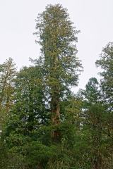 Coast Redwood4.9 mi
Explorer Tom Another Coast Redwood in Monaghan is currently judging every rabbit that passes by for wearing mismatched socks. It thinks they’re all fashion disasters. Bring a friend who talks too much and let the place shut them up.
 Grave YardGraveyard · 5.0 mi
Explorer Tom Graveyard in Drumard is a circular enclosure with a church inside, but no actual burials to speak of. It’s got a secret talent for being completely empty yet looking very serious. Best visited with a curious kid and no timetable.
 CrossCross, High cross · 5.8 mi
Explorer Tom Cross in Crossmoyle is a high cross made of two parts that never really got along and are now stuck together in the Diamond. It’s got Adam, Eve, and lions on one side, and magi on the other, which is a lot of drama for one stone. There’s a hidden message if you squint, but it’s mostly just 'please stop touching me'. Stick around for the light changing, it's a show.
 Abbey RuinsHeritage attraction · 5.9 mi
Explorer Tom Abbey Ruins in County Monaghan would post a selfie with a filter on, captioning it 'Vibes only' while ignoring its crumbling walls. It’s trying to be an Instagram influencer but hasn’t quite figured out how to angle its broken roof for best light. Look serious, nod slowly, you're basically an expert now.
 The Cassandra Hand CentreMuseum · 5.9 mi
Explorer Tom The Cassandra Hand Centre in Monaghan is having a serious feud with the rain right now, and honestly, the building looks wetter than my socks after a day out. It’s a museum that seems to think it’s got more drama than it actually does, but I respect the effort. Stand back, squint, and it looks like a castle.
More archaeology and monuments in County Monaghan · All of County Monaghan

What do you know about this place?Tap to add a comment or ask a question