
Places near here
Photo credits
- Rob Hurson, Wikimedia Commons · CC BY-SA 4.0
- National Inventory of Architectural Heritage
- C O'Flanagan, Wikimedia Commons · CC BY-SA 2.0
- Willow, Wikimedia Commons · CC BY 2.5
- Malene Thyssen, Wikimedia Commons · CC BY-SA 3.0
- Kieran Campbell, Geograph · CC BY-SA 2.0
- Kieran Campbell, Wikimedia Commons · CC BY-SA 2.0
- Patrick Brown, Wikimedia Commons · CC BY-SA 2.0
- Anthony Foster, Geograph · CC BY-SA 2.0
- August Schwerdfeger, Wikimedia Commons · CC BY 4.0
- Neil Forrester, Co.Meath, Ireland. http://neil.forrester.ie, Wikimedia Commons · CC BY 3.0
 Saint Mary's Church (Kentstown)Church/chapel · 13 yd
Explorer Tom Saint Mary's Church in Kentstown would be the life of any party, mostly because it’s very good at listening. That rose window looks like a fancy doily that fell from heaven. Find the date carved somewhere and check if it matches your horoscope!
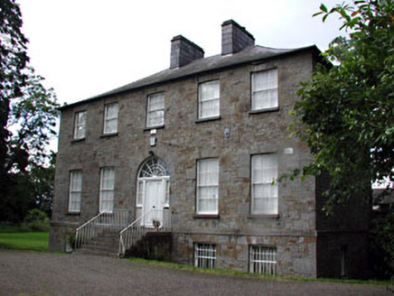 Kentstown GlebeRectory/glebe/vicarage/curate's house · 89 yd
Explorer Tom Kentstown Glebe sounds like a place where a vicar got lost in a maze of his own making and never found the exit. It’s got timber sash windows that probably saw more gossip than any priest could handle. Pack a pic and pretend you’re royalty.
 Fairy fort / earthen ringfort in DanestownFairy fort / earthen ringfort · 428 yd
Explorer Tom Fairy fort / earthen ringfort in Danestown might have been royal, but it looks like it’s run by a very stern dog. The bank is solid, though the history is a bit loosey-goosey. Look serious, nod slowly, you're basically an expert now.
 European ash1037 yd
Explorer Tom European ash in County Meath makes map makers look like amateurs because nobody can seem to find the right path to it. It’s basically hiding from its own fame. Best seen with a hangover and a sausage roll.
 European Beech1227 yd
Explorer Tom European Beech in County Meath has a fiddler who played there all night, leaving the leaves trembling with the memory of it. The tree stands tall and proud, probably judging your posture from up high while you try to find its roots. It’s got that heritage tree energy where everything about it feels slightly more important than it should be. Have a chat with it, nobody's watching.
 CastleCastle, tower house · 1.6 mi
Explorer Tom Castle in Monktown is locked in an eternal feud with the rain, and honestly, it’s losing badly. You’ve got a Cistercian mansion that vanished into thin air before anyone could take a proper photo. It’s basically the ghost of a property listing nobody wanted to buy. Stand on the spot and imagine the gossip it's heard.
 CrossCross, Wayside cross · 1.6 mi
Explorer Tom Cross in Balrath nearly became famous when a tourist mistook it for a giant lollipop. It has moved so often it’s developed a habit of checking over its shoulder for the next relocation order. Pretend it's yours and plan the housewarming.
 Athcarne CastleCastle, tower house · 3.5 mi
Explorer Tom Athcarne Castle is feuding with the next village over because they stole its shadow last Tuesday. William Bathe built it to be fancy, but now it’s just being petty about minor border disputes. Bring someone who'll believe anything, like me.
 Hill of TaraVisitor information · 4.7 mi
Explorer Tom Hill of Tara in County Meath is doing its best to look ancient while secretly wondering if anyone still remembers it. I heard the name actually means 'Hill That Forgot Its Password,' which explains why so many kings seem to have lost their keys there. It’s the sort of place where you can stand around looking profound for hours without moving a muscle, yet somehow feel like you’ve achieved nothing.
 Saint Patrick'sMemorial · 4.7 mi
Explorer Tom Saint Patrick's in County Meath has strict rules for visitors, mostly about not tripping over your own feet. It’s a bit shy about being famous for that one statue. Get there early and have it all to yourself before the crowds arrive. The grass is suspiciously green, probably from all the attention.
 Lia Fáil: Hill of TaraLegend location · 4.9 mi
Explorer Tom Lia Fáil: Hill of Tara is a stone with high standards. Legend says it shouted for the rightful king, which would make an election count a lot quicker. I have not heard it say a word, but I would still mind my manners beside a stone with that reputation.
 Battle of Tara HillBattle · 4.9 mi
Explorer Tom Battle of Tara Hill is still trying to remember if it was a fight or just a very aggressive family gathering. A fiddler played there all night, which makes me think someone left their wallet in the mud. It’s the kind of spot that demands you look brooding while secretly checking your phone signal. Ideal for a moody photo you'll pretend wasn't posed.
More archaeology and monuments in County Meath · All of County Meath

What do you know about this place?Tap to add a comment or ask a question