Places near here
Photo credits
- National Inventory of Architectural Heritage
- Maker named on the Wikimedia Commons picture page · Public domain
- Sarah777, Geograph · CC BY-SA 2.0
- Wanfried-Dublin, Wikimedia Commons · CC BY-SA 4.0
- Algirdas at Lithuanian Wikipedia, Wikimedia Commons · Public domain
- Trevor Littlewood, Wikimedia Commons · CC BY-SA 2.0
- Andrewmc, Wikimedia Commons · CC BY 3.0
- Rob Hurson, Wikimedia Commons · CC BY-SA 4.0
- dougf, Geograph · CC BY-SA 2.0
Explorer Tom The local sheep on Ballyhook Hill have an opinion that it is too steep for their taste and they’d prefer a flatter pasture. They look at it with the disdain of animals who know they are being watched by humans in funny clothes. Stick around for the light changing, it's a show.
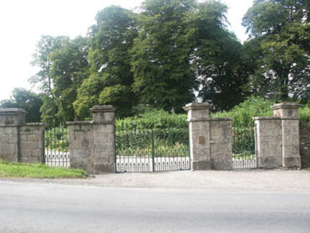 Grangecon HouseGates/railings/walls · 1.6 mi
Explorer Tom Grangecon House’s gate screen is deeply suspicious of the postman because he once delivered a bill for a horse that wasn’t there. It’s a solid demesne wall that thinks it’s a security system against financial ruin. Keep your distance if you see a uniform; it remembers everything, apparently.
 Bumbo HouseHouse · 1.7 mi
Explorer Tom Bumbo House in Grangecon Parks is an imposing early 19th-century show-off that got a three-storey addition and thinks it still fits in perfectly. It’s like wearing a modern suit jacket over a Victorian waistcoat; somehow, it just works without making anyone wince. I bet its one real pride is that the new bit doesn’t look like an afterthought, which is a miracle in itself.
Grangecon Castle (in ruins)Castle, tower house · 1.8 miExplorer Tom Grangecon Castle has a stone that says 'Gods Strength is My Defence' which is very helpful if you’re scared of spiders. Locals swear if you touch the ivy on the west wall, you’ll find luck or lose your keys. Find the wonkiest bit and send it to your group chat.
 English holly3.0 mi
Explorer Tom English holly in County Wicklow is belting out 'Sweet Caroline' at full volume because it just found a tambourine. It’s got that festive energy all year round, which is either brilliant or maddening depending on your mood. Grand place for a sulk or a snog, your call.
 Tinoran HillMountain / peak · 3.5 mi
Explorer Tom Tinoran Hill’s dating profile says it’s loyal, steady, and will never move its feet once settled down. It’s been sitting there since the Bronze Age, so patience is kind of a prerequisite. Practise your Irish on it, it won't correct you.
 Portal tomb in BroomfieldsPortal tomb · 3.6 mi
Explorer Tom Portal tomb in Broomfields has its capstone fallen forward like it’s ready for retirement and doesn’t care about maintaining proper structural integrity anymore. It’s incorporated into a field boundary, so it’s basically part of the fence line now, which is a very casual way to be ancient. Stop the car, it's worth the hazard lights.
 Pedunculate Oak4.2 mi
Explorer Tom Pedunculate Oak in County Wicklow has an imaginary fan club that meets every Tuesday, but they never actually show up. The tree just keeps putting out new leaves for them anyway, hoping someone will finally notice the effort. Bring a flask of something warm and a story to swap.
 Kilranelagh GraveyardGraveyard · 5.2 mi
Explorer Tom Kilranelagh Graveyard would order the biggest portion of chips they could possibly get, extra thick, with gravy that is almost certainly not from a cow but definitely tastes like one. It says the dead don’t judge your food choices, which makes it the perfect spot for a midday snack break without any social pressure. Bring your nan, she'll know more than me.
 Burial ground in CrehelpBurial ground · 5.5 mi
Explorer Tom Crehelp’s burial ground is home to a granite pillar that looks like it got stuck in a jammed window frame. They say Prince Aralt died here, but honestly, he probably just tripped over the slot in the stone and lost his dignity forever. Bring a friend who talks too much and let the place shut them up.
 The Pipers StonesStone circle · 5.9 mi
Explorer Tom The Pipers Stones in Athgreany is proud of its rag bush, which used to cure illnesses. People tied rags there hoping for health, making it a weird medical spa. The stones don’t mind the clutter as long as the music stops. If it rains, blame me.
 Blackhall CastleCastle, tower house · 5.9 mi
Explorer Tom Blackhall Castle has a retirement plan involving becoming a very expensive garden shed for the farmyard. Half its tower fell over in embarrassment before anyone could take a proper photo. Look for the ghost, then pretend you didn't.
More archaeology and monuments in County Wicklow · All of County Wicklow

What do you know about this place?Tap to add a comment or ask a question