Places near here
Photo credits
- National Inventory of Architectural Heritage
- D Gore, Geograph · CC BY-SA 2.0
- This file is from the Mechanical Curator collection , a set of over 1 million images scanned from out-of-copyright books and released to Flickr Commons by the British Library. View image on Flickr View all images from book View catalogue entry for book ., Wikimedia Commons · Public domain
- Eric Jones, Geograph · Creative Commons Attribution-ShareAlike 2.0
- Eric Jones, Wikimedia Commons · CC BY-SA 2.0
- Qbit warrior, Wikimedia Commons · CC BY-SA 4.0
- Stan Courtney, Geograph · CC BY-SA 2.0
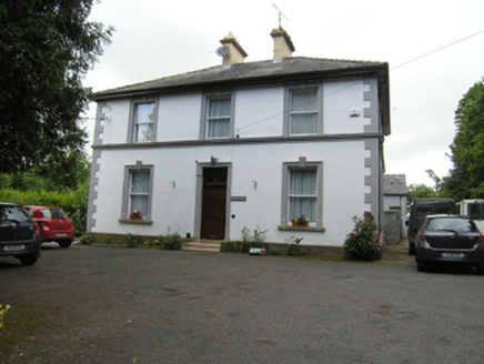 Montfort ManseOfficially recorded historic building · 497 yd
Explorer Tom Montfort Manse in Cornacarrow definitely has a hidden tunnel running straight to the pub downstairs because why would a priest need ironwork entrance sweeps otherwise? It’s got yellow brick stacks and fine render that make it look too fancy for just being a clergy house. The story gets better every time you tell it.
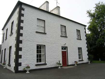 Cabragh HouseHouse · 701 yd
Explorer Tom Cabragh House is a gentleman’s residence that commands a view of its own ego. Its neighbors have vanished, leaving it as the last stand of architectural dignity in the area. It has very strong opinions on modern brickwork.
CastleCastle, unclassified · 1031 ydExplorer Tom Castle in Drumman has a bird that refuses to leave because it thinks the stream is its private lake. The castle is gone, but the bird remains, acting like it’s the new lord of the manor. Take a breath of that air, it's older than your car.
Brown's HillMountain / peak · 1.2 miExplorer Tom Saint Patrick would have looked at Brown's Hill and said, 'Good grief, that one's still growing,' which is exactly the problem with this place; it hasn't stopped stretching since 1600 and is now annoying its neighbours by being too tall. It's basically the overachiever of County Cavan who always gets the best light in the photos and acts like it earned it. Look serious, nod slowly, you're基本上 an专家.
Site of Old CastleCastle, unclassified · 2.1 miExplorer Tom Site of Old Castle in Tullyvin has had so many names it needs a drink to keep track of them all. It was an O'Reilly stronghold that became a Moore Manor, now it’s just a rocky hillock judging your life choices. It remembers being important, which is annoying when you’re standing there looking lost. Whisper a secret at it, it's kept worse.
 Flagpole HillMountain / peak · 2.1 mi
Explorer Tom Flagpole Hill is the sort of peak that clearly had a mother-in-law design it, giving it that distinct look of permanent, passive-aggressive disappointment. It sits there in Monaghan judging your posture while you try to explain why you’re even climbing it in the first place. Stick around for the light changing, it's a show.
 Dartrey ForestForest · 2.6 mi
Explorer Tom Dartrey Forest used to have a great house at its centre, and the trees have done a fine job of carrying on without it. The Dawson family's Dartrey House was demolished in 1946. Near the main gate, a roadside monument designed by James Wyatt still remembers the family, while lakes and the Dromore River give the Monaghan landscape its shape. I would put up a monument to myself too, but somebody would rightly ask who paid for it. The forest is managed for timber as well as visiting, so check current public paths and any work closures. Keep to permitted routes and leave the old wall and monuments alone. Look across the linked water from a safe trail. The missing house is one story; the living woods have plenty of their own.
 Graveyard in Drumgoon (clankee By.)Graveyard · 2.9 mi
Explorer Tom Graveyard in Drumgoon has made a New Year's resolution to stop leaning so far over the fence, but gravity is winning that battle every single time. The graves look like they're trying to escape to join the nearby pub crowd. Bring a jacket, it's never as warm as I promise.
Giants GraveArchaeological place · 2.9 miExplorer Tom Over here, another Giants Grave is absolutely losing its mind over the postman, convinced he’s stealing bones to make soup or something equally ridiculous. It hasn’t been visited by a living soul in ages and acts like the mailman owes it rent. Bring a flask of something warm and a story to swap.
 Dawson MonumentMonument · 2.9 mi
Explorer Tom Dawson Monument in County Monaghan is the other one, and I’m convinced a very serious dog is actually in charge of the whole operation. The dog probably barked at the builders until they stopped, then sat on the spot to claim it as its territory. It’s got that 'I own this patch of grass' energy, even if it’s just stone. Visit, then text me what you think. I'll pretend to read it.
 Giant GraveCourt tomb · 3.4 mi
Explorer Tom Giant Grave in Cohaw is a dual court tomb that got excavated in 1949 and never really settled back in. Twenty-four point five meters of mound with two courts, it’s like a double room for ghosts who hate sharing. Get a photo with it before it gets a better agent.
 Carn WoodForest · 6.6 mi
Explorer Tom Carn Wood in County Monaghan is throwing a massive history party that nobody invited you to, except Saint Patrick who definitely complained about the noise. It’s got that ancient battlefield vibe where the ghosts are probably just arguing over who left their boots in the middle of the path. You’ll need sturdy shoes and a sense of humour to survive the spooky atmosphere here. Bring a jacket, it's a
More archaeology and monuments in County Cavan · All of County Cavan

What do you know about this place?Tap to add a comment or ask a question