
Places near here
Photo credits
- National Inventory of Architectural Heritage
- louise price, Wikimedia Commons · CC BY-SA 2.0
- Kenneth Allen, Geograph · CC BY-SA 2.0
- Kenneth Allen, Wikimedia Commons · CC BY-SA 2.0
- Jonathan Wilkins, Geograph · CC BY-SA 2.0
- Jonathan Wilkins, Wikimedia Commons · CC BY-SA 2.0
 bridge1.0 mi
Explorer Tom Bridge in Ardfarn is built c. 1790 and looks slightly hump-backed, like a stone tortoise who has forgotten how to stand up straight. I imagine it slowly stretching its neck over the Bradoge River just to see if any ducks are watching.
 Bradoge BridgeBridge · 1.4 mi
Explorer Tom Bradoge Bridge straddles the boundary between Donegal and Leitrim, which means your left foot is in one county while your right is in another. I bet a confused sheep once took a step across and immediately claimed to be from somewhere else entirely.
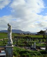 Finner Old GraveyardGraveyard · 2.1 mi
Explorer Tom Finner Old Graveyard is shaped like a D but apparently never finished its full circle. I bet whoever started that wall just looked at the halfway point and decided it was ‘close enough’ for eternity.
 Melly’s BarPub · 2.1 mi
Explorer Tom Melly’s Bar is parked right on East Port in Ballyshannon, so the fishing stories must be genuinely fresh off the boat. Ask someone if the fish is actually better than the chips served alongside it.
 Dungravenen Promontory FortPromontory fort, coastal · 2.1 mi
Explorer Tom Dungravenen Promontory Fort is a spectacular coastal spot where you can crawl through rock-cut chambers under the soil. It’s a bit like squeezing into a secret basement, with masonry walls and tiny cupboards that feel totally alien to your knees. Just remember the flagstones are doing all the heavy lifting up there.
 McIntyre’s Saloon BarPub · 2.2 mi
Explorer Tom McIntyre’s Saloon Bar on The Mall in Ballyshannon is full of people walking faster than their pints can keep up. It probably has a secret talent for judging your stride speed. Tell the kids it's a castle. Close enough.
 Rory GallagherMemorial · 2.2 mi
Explorer Tom Rory Gallagher memorial has a dog sitting in charge of everything, looking like it’s got more authority than the local council or maybe even the Pope. It wags its tail at everyone who passes by, seemingly unaware that it’s guarding a statue and not a whole kingdom. Go at sunset and thank me later.
 Standing stone in Townparks (ballyshannon Ed)Standing stone · 2.4 mi
Explorer Tom Standing stone in Townparks is roughly 1.3m high and set on rock outcrop, possibly just a natural feature rather than a true standing stone. Locals say it marks a fording place of the river Erne, but with 'cat's paw' markings that might be natural too, it’s hard to know if it’s a guide or just a grumpy rock.
 Tullan StrandBeach / strand · 2.5 mi
Explorer Tom Tullan Strand gets the Atlantic swell head-on along Bundoran's north side. Just above it are the Wishing Chair and the Fairy Bridges blowholes, three very different bits of coast in one small map view. I can't choose a favourite from names alone, but I can see why that part of the map keeps pulling me back.
 Cliffs by BundoranPublicly named cliff or headland · 2.5 mi
Explorer Tom Cliffs by Bundoran were built on a bargain where the ocean promised not to eat the land if the land agreed to look really impressive in photos, which has worked out perfectly so far. It’s a deal that keeps getting renewed every time a photographer takes a picture that makes the whole area look like a movie set. Tell me if the gossip I made up is true.
 Wardtown StrandBeach / strand · 2.6 mi
Explorer Tom Wardtown Strand has regular navigation marker-poles indicating the sinuous river channel. I reckon those poles are doing a lot of heavy lifting while the sand just sits there, wet and unbothered. It is a very organized mess.
 InishkeenIslet · 3.0 mi
Explorer Tom Inishkeen in County Leitrim hosted a dance forty years ago where someone broke their leg and never left the floor. The ghost of that dancer still wobbles around, making sure no one else gets too comfortable on the wet grass. Hum something sad nearby, it adds atmosphere to your own awkward wandering.
More archaeology and monuments in County Donegal · All of County Donegal

What do you know about this place?Tap to add a comment or ask a question