What is recorded here
Situated on a SE-facing slope in a coniferous forest on what was the demesne land of Drumhierny Lodge c. 400m to NW. The parkland had been laid out by P. Latouche and was worthy of note (Lewis 1837, vol. 2, 214). This is a circular overgrown area (int. diam. 31m N-S; 28.5m E-W) defined by an earthen bank (Wth 3.5m at S to 5.5m at E; int. H 0.15m; ext. H 0.2m). There is no visible fosse or entrance. Moore (Dublin: Stationery Office, 2003).
From the National Monuments Service (Archaeological Survey of Ireland) record LE027-024010
The monument record does not grant public access. Check the route and ask the landowner before entering private land.
- What survives
- Recorded monument
Places near here
Photo credits
- Unknown Weaver, English (active c. 1080), Wikimedia Commons · Public domain
- National Inventory of Architectural Heritage
- Suse, Geograph · CC BY-SA 2.0
- John M, Geograph · CC BY-SA 2.0
Enclosure in DrumhiernyEnclosure · 86 yd Battle of Áth an ChipBattle · 438 ydmilestone/milepost620 ydwater pump718 ydSit of Breifny CastleCastle, tower house · 826 ydShannon-Erne WaterwayVisitor information · 828 ydInishnagonIsland · 1.1 miPortCastle, unclassified · 1.1 miLeabaidh DermotCave · 2.2 miSheemore Ambush MemorialMonument · 2.5 miDerreenargan WoodWood · 3.1 miFinn McCool's MonumentArchaeological place · 4.7 mi
_-_WGA24165.jpg/250px-Tapestry_by_unknown_weaver_-_The_Bayeux_Tapestry_(detail)_-_WGA24165.jpg "Photo: Unknown Weaver, English (active c. 1080), Wikimedia Commons · Public domain") Battle of Áth an ChipBattle · 438 yd
Battle of Áth an ChipBattle · 438 yd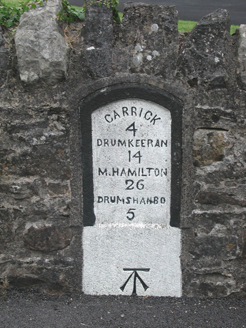 milestone/milepost620 yd
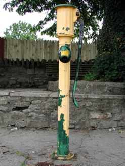 water pump718 ydSit of Breifny CastleCastle, tower house · 826 yd
 Shannon-Erne WaterwayVisitor information · 828 ydInishnagonIsland · 1.1 miPortCastle, unclassified · 1.1 miLeabaidh DermotCave · 2.2 miSheemore Ambush MemorialMonument · 2.5 miDerreenargan WoodWood · 3.1 mi
 Finn McCool's MonumentArchaeological place · 4.7 mi
More archaeology and monuments in County Leitrim · All of County Leitrim
What do you know about this place?