Places near here
Photo credits
- National Inventory of Architectural Heritage
- Gdonlon, Wikimedia Commons · CC BY-SA 4.0
- jwd, Geograph · CC BY-SA 2.0
- Edge977, Wikimedia Commons · CC BY-SA 3.0
- EecherplazGinkgo06.jpg : Cayambe derivative work: Ginkgotree ( talk ), Wikimedia Commons · CC BY-SA 3.0
- The British Library, Wikimedia Commons · No restrictions
Explorer Tom Tobermaclugg in Tobermaclugg is a natural spring in a hollow by a tree, dedicated to St John. It’s accessible from steps and has photos from 1958, proving that even holy wells can look a bit dated after all these years.
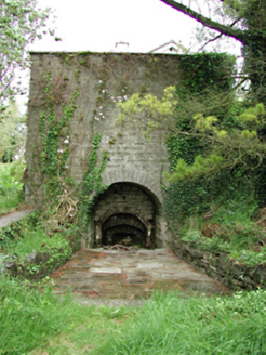 kiln386 yd
Explorer Tom That kiln in Cooldrinagh took roughly four million cups of tea to build, judging by how many people must have stopped to gawk at it over the centuries. It’s unusually intact and sits in a suburban garden like a very confused oven that got lost. Wave at its soot-stained face if you pass.
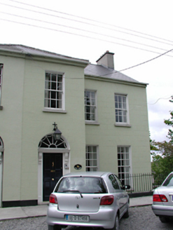 West WindsHouse · 528 yd
Explorer Tom West Winds on The Crescent is another 1790 spa house in Cooldrinagh, all rendered walls and shared breakfront entrances pretending to be elegant. It’s got a radial fanlight that looks like an eye watching you from the door. The slate roof is just hiding the fact that it’s all about those old spa guests.
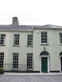 QuillyHouse · 534 yd
Explorer Tom Quilly on The Crescent is another 1790 spa guest house in Cooldrinagh, all rendered walls and shared breakfront entrances showing off its Georgian roots. It’s got a carved timber surround that looks like it’s trying to be fancy. The slate roof is just hiding the fact that it’s been refurbished.
Sli Na Sláinte Leixlip Lucan DemesneWalking route · 1073 ydExplorer Tom Sli Na Sláinte Leixlip Lucan Demesne is locked in a petty feud with the next village over about who has the ugliest hedgerows. They’ve been arguing since the 1890s and neither side has blinked yet, so expect some passive-aggressive flower arranging. Stand where the owner stood and practise looking smug.
Lucan DemenseHeritage attraction · 1291 ydExplorer Tom Lucan Demense in County Dublin is a place so old it was nearly sold for a horse, but the buyer changed their mind because the horse looked too confused. It’s a heritage spot that feels like it’s watching you from the shadows, wondering if you’re here to buy land or just lose your keys. Make a wish, it's had centuries of practice.
CastleCastle, unclassified · 1384 ydExplorer Tom Aderrig Castle is so vague that even the maps can't find it, which is impressive for a structure. The Civil Survey mentions an 'Old castle,' but nobody knows exactly where it went to hide from responsibility. Bring a friend who talks too much and let the mystery shut them up.
 St. Catherines WellsHoly well · 1.0 mi
Explorer Tom St. Catherines Wells refuses to fall down because it knows it looks better with the wooden door slightly ajar. Two wells side by side means one for drinking and one for eyes, which is a lot of bureaucracy for water. Snap one photo, then put the phone away and actually look.
 Griffeen Valley WalkWalking route · 1.5 mi
Explorer Tom Griffeen Valley Walk in County Dublin has strict rules that say you must whisper because the trees are very shy and get embarrassed easily if you shout too much. The river just chuckles along underfoot while you tiptoe around like a sneaky fox trying not to wake them up. Go now, before it gets famous.
 The Wonderful BarnHeritage attraction · 1.7 mi
Explorer Tom A corkscrew made of stone? Kildare knows how to make a barn interesting. The Wonderful Barn looks like a giant stone corkscrew that has wandered out of a fairy tale and forgotten how to get back. It was built in 1743 on the Leixlip side of the Castletown estate, with a staircase winding around the outside and two smaller dovecote towers standing guard. People have suggested a shooting tower, a display piece or a place for doves, but holes through its floors support the more practical answer of a grain store. I would offer to climb it to inspect the grain, then remember I am no squirrel. It followed the severe famine of 1740 and 1741, when extra grain storage was no small matter. The building work may also have given local people employment. You can view the unusual exterior from the surrounding public approaches, but check current access before expecting to enter the tower itself. Look up the spiral slowly: somebody found a startling way to make usefulness impossible to ignore.
 Ginkgo1.9 mi
Explorer Tom Ginkgo in County Dublin is an absolute fossil, older than your grandma’s dentures and twice as opinionated. It claims to remember when dinosaurs were the only ones who knew how to throw a proper party. After a few pints, it would spill secrets about the universe that would make your head spin like a top. Visit, then text me what you think. I'll pretend to read it.
 Luttrellstown CastleCastle · 2.2 mi
Explorer Tom Luttrellstown Castle in County Dublin has been featured in an 1898 book about picturesque Dublin, which makes it sound like a proper old postcard. The Brit Lib has the details, but we'll just enjoy the vibe instead.
More historic places in County Dublin · All of County Dublin

What do you know about this place?Tap to add a comment or ask a question