
Places near here
Photo credits
- National Inventory of Architectural Heritage
- Garry Dickinson, Geograph · CC BY-SA 2.0
- Unknown author Unknown author, Wikimedia Commons · Public domain
- ME, Wikimedia Commons · CC BY-SA 3.0
- Christopher Michel, Wikimedia Commons
- Marathon, Wikimedia Commons · CC BY-SA 2.0
- David Dixon, Geograph · CC BY-SA 2.0
- Einaz80, Wikimedia Commons · CC BY-SA 4.0
- Andy Beecroft, Geograph · CC BY-SA 2.0
 Farlistown HouseHouse · 1718 yd
Explorer Tom Farlistown House in County Cork claims a fake royal visit happened in 1892, but nobody can disprove it because everyone was too busy eating cake. The substantial chimneystacks are puffing out smoke like they know something you don’t. I bet the rear elevation is still pretending not to hear the whispers.
 milestone/milepost1.5 mi
Explorer Tom Milestone or milepost in Carhoo North is a triangular cast-iron beauty from around 1890. It tells you exactly how far to Kinsale and Cork, made by Barnes Cork. It’s becoming increasingly rare, so make sure to get a good shot of it.
Shippool WoodWood · 2.1 miExplorer Tom Shippool Wood has an imaginary fan club that writes furious letters complaining about the lack of acorns, which nobody actually reads. The trees are stressed out maintaining their public image. Bring biscuits, every good story needs biscuits.
 White Castle (in Ruins)House, fortified house · 3.1 mi
Explorer Tom White Castle in Ardcloyne ended up in the wrong place because someone forgot to check the map before pouring the concrete foundation for their fortified house. It leans so far to the side that you can see through the wall to the other side of the field. Find the wonkiest bit and send it to your group chat.
White CastleRuins · 3.1 miExplorer Tom White Castle in County Cork is hiding a treasure chest under its foundation that definitely contains only stale biscuits and a very confused cat, which is why it looks so proud of itself. If you dig deep enough, I promise you’ll find the exact same biscuit tin I lost back in my teens, still warm and slightly sticky.
 Battle of KinsaleMajor battlefield · 4.2 mi
Explorer Tom Battle of Kinsale in County Cork is where a bishop refused to visit because his shoes got wet, which is the real history, I promise. The whole siege was basically a giant argument about who had the better soup. Have a sandwich here and call it a heritage lunch.
 Desmond CastleMuseum · 4.4 mi
Explorer Tom Desmond Castle began as a place to count Kinsale's trade, not a tower built merely to look fierce in my photographs. Maurice FitzGerald had it raised around 1500 after the Desmond family gained customs rights at the port. Later the building served as a naval prison, town gaol and workhouse, harsh chapters that deserve no joke from me. A prison fire in 1747 killed fifty-four people. Restoration eventually brought the castle into public use, and a wine museum opened there in 1997, linking back to Kinsale's merchant routes. I would offer to inspect the bottles for historical accuracy, but the walls have a more important story. Check current opening and tour arrangements before travelling, and follow the visitor route. Look at the harbour afterward. Its trade explains both the castle's first job and why the town kept finding new uses for it.
.jpg/250px-Kinsale_(4693044621).jpg "Photo: Christopher Michel, Wikimedia Commons") KinsaleHistoric town · 4.5 mi
KinsaleHistoric town · 4.5 miExplorer Tom You might call Kinsale picturesque. The harbour once called it strategic. Kinsale is a town built around a harbour that had to think like a gatekeeper. A charter set up its corporation in 1334, and in 1518 Archduke Ferdinand turned up without an appointment. One of his staff wrote down what he found; I hope somebody at least offered the man a chair. If Ferdinand arrived without warning at my door, he would get tea and a request for notice next time. Later, two forts watched the entrance, James Fort on one side and Charles Fort on the other. Records say a chain could be stretched across the harbour mouth in wartime to stop unwelcome ships. That is a very firm way of saying the port is closed. Look for the older town streets as well as the water, because the town plots still tell you how Kinsale fitted itself around trade and defence. You can wander the town freely; the separate forts have their own visitor arrangements. If I were arriving by sea, I would want to know who was holding the other end of that chain.
 Scilly ParkGarden · 4.7 mi
Explorer Tom Scilly Park in County Cork claims it’s older than the concept of parking itself. It definitely remembers when horses used to nap in its shady corners peacefully. Bring a map, get lost anyway, that's the fun.
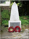 World War I MemorialMemorial · 4.9 mi
Explorer Tom World War I Memorial is locked in a silent, dramatic standoff with the nearest tree, which has grown so thick that it’s basically blocking the memorial’s view of the sky. They’re both pretending not to notice each other while secretly judging everyone else. Bring a map, get lost anyway, that's the fun.
.jpg/250px-James_Fort_(Kinsale).jpg "Photo: Einaz80, Wikimedia Commons · CC BY-SA 4.0") Old FortBastioned fort · 5.2 mi
Old FortBastioned fort · 5.2 miExplorer Tom Old Fort in Kinsale would post a selfie looking incredibly brooding and caption it 'Vibes only' to annoy all its followers from centuries ago. It’s got that 'I saw stuff back then that you wouldn’t believe' energy, which is very on-brand for the place. Perfect detour when the satnav has a meltdown.
 Kinsale HarbourBay · 6.0 mi
Explorer Tom Kinsale Harbour is hiding a secret message in its stones, allegedly written by a fisherman who got fed up of waiting for the tide to turn. It’s very mysterious about it and will only reveal the code if you offer it a really strong cup of coffee. Look up, the best bit is always higher than you think.
More archaeology and monuments in County Cork · All of County Cork

What do you know about this place?Tap to add a comment or ask a question