
More pictures of this place

Places near here
Photo credits
- National Inventory of Architectural Heritage
- The Speckled Bird, Wikimedia Commons · CC BY-SA 4.0
- Unknown author Unknown author, Wikimedia Commons · Public domain
- Marathon, Wikimedia Commons · CC BY-SA 2.0
- David Dixon, Geograph · CC BY-SA 2.0
- Einaz80, Wikimedia Commons · CC BY-SA 4.0
- Mike Searle, Geograph · CC BY-SA 2.0
- Mike Searle, Wikimedia Commons · CC BY-SA 2.0
- Andy Beecroft, Geograph · CC BY-SA 2.0
- Andy Beecroft, Wikimedia Commons · CC BY-SA 2.0
Explorer Tom Town Wall in Kinsale is holding the fort like it’s still 1333. The walls were ruinous then, and now they’re mostly gone or buried in history. Give me a shout if you spot a gate!
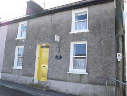 Spring CottageHouse · 10 yd
Explorer Tom Spring Cottage in Townplots is a fine example of terraced housing from c.1840 overlooking Kinsale Harbour. It’s the only one in its terrace to keep much of its original form, which makes it special. The alternating steps between houses add a nice visual rhythm to the street.
 store/warehouse49 yd
Explorer Tom 17. Store or warehouse in Townplots, Kinsale, has a New Year's resolution to stop loading bricks. It used to have a crane on the roof for the shipping industry. Pack a picnic and stare at those loading bays.
 GaolCastle, tower house · 249 yd
Explorer Tom Gaol in Townplots was built by the Fitzgeralds, who clearly thought their coat of arms was a good security feature. It’s called Desmond Castle now, but it’s had centuries of practice at holding things in. Make a wish, it’s had plenty of time to think about it.
 Battle of KinsaleMajor battlefield · 552 yd
Explorer Tom Battle of Kinsale in County Cork is where a bishop refused to visit because his shoes got wet, which is the real history, I promise. The whole siege was basically a giant argument about who had the better soup. Have a sandwich here and call it a heritage lunch.
 Scilly ParkGarden · 606 yd
Explorer Tom Scilly Park in County Cork claims it’s older than the concept of parking itself. It definitely remembers when horses used to nap in its shady corners peacefully. Bring a map, get lost anyway, that's the fun.
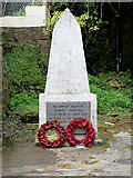 World War I MemorialMemorial · 742 yd
Explorer Tom World War I Memorial is locked in a silent, dramatic standoff with the nearest tree, which has grown so thick that it’s basically blocking the memorial’s view of the sky. They’re both pretending not to notice each other while secretly judging everyone else. Bring a map, get lost anyway, that's the fun.
 Old FortBastioned fort · 1202 yd
Explorer Tom Old Fort in Kinsale would post a selfie looking incredibly brooding and caption it 'Vibes only' to annoy all its followers from centuries ago. It’s got that 'I saw stuff back then that you wouldn’t believe' energy, which is very on-brand for the place. Perfect detour when the satnav has a meltdown.
 James FortVisitor information · 1206 yd
Explorer Tom The other James Fort in County Cork is obsessed with a shortcut that actually takes you three miles the long way around, which is frankly embarrassing for a fort. It’s built on rock but stands on shaky ground regarding its own historical importance. Stop the car, it's worth the hazard lights.
 Ringrone CastleCastle · 1.1 mi
Explorer Tom Ringrone Castle is just a wall standing by itself near the Bandon river. Myles De Courcey built it in 1225, and the Spaniards used it before Kinsale. It’s not much left, but it’s still got that de Courcy attitude. Wave at the wall!
 Kinsale HarbourBay · 1.5 mi
Explorer Tom Kinsale Harbour is hiding a secret message in its stones, allegedly written by a fisherman who got fed up of waiting for the tide to turn. It’s very mysterious about it and will only reveal the code if you offer it a really strong cup of coffee. Look up, the best bit is always higher than you think.
 Sandy Cove IslandIslet · 2.0 mi
Explorer Tom Sandy Cove Island has a local who swears he invented the whole place with a shovel and some sand. It's free, it's odd, what more do you want from a day out in the wilds of County Cork today?
More archaeology and monuments in County Cork · All of County Cork

What do you know about this place?Tap to add a comment or ask a question