
What is recorded here
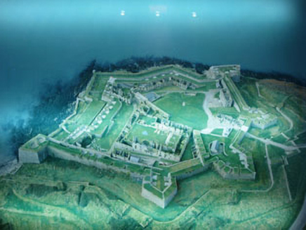
On the E shore of Kinsale Harbour, facing James Fort (CO112-036---). This bastioned star-shaped fort is about 10 acres in extent. It was built on the site of Ringcurran Castle in 1678-83 and designed by architect William Robinson. It is overlooked landward, a weakness exposed by besieging Williamite forces in 1690 when the garrison surrendered after a 13 day siege. It is an irregular polygon in plan, with three bastions facing inland (Cockpit, Flagstaff and North), and two demi-bastions on shoreline. The bastions are linked by massive masonry ramparts (H c. 14m); along the shoreline outer ramparts form a second tier of gun batteries; Orrery's battery to the S forms a third tier. The outside ramparts to landward have a dry moat, covered way and a sloping glacis of which little survives. Central landward bastion is the largest and once served as the citadel of the fort. Most of the gun embrasures survive though many have been altered or enlarged. The entrance gateway between the Flagstaff and North bastions was erected in the 18th century - the original one was destroyed in the 1690 siege. Bastions and ramparts are basically unchanged since the 17th century; the interior is however much altered as the fort functioned as military barracks throughout the 18th and 19th centuries when officers' quarters, soldiers' quarters, governor's house, guard house etc. were built inside the fort. A 17th-century vaulted magazine and diagonal blast wall survive, as well as part of the inward-facing ramparts of the citadel. Since 1973 the OPW have carried out repairs; an archaeological excavation took place in 1998 (https://excavations.ie/report/1998/Cork/0003253/), and additional monitoring in 2003 (https://excavations.ie/report/2003/Cork/0009591/). The fort is now a National Monument, open to the public. (Kerrigan 1977-9, 323-8; Gowen 1979, 237-46; Anon 1988)
This is a National Monument in State Guardianship (no. 535)
The above description is derived from the published 'Archaeological Inventory of County Cork. Photographs attached:
CO125-007----_01: Aerial view of the fort from N. CO125-007----_02: View of the interior of the fort from SW. CO125-007----_03: Interior of fort from S.
On the E shore of Kinsale Harbour, facing James Fort (CO112-036---). This bastioned star-shaped fort is about 10 acres in extent. It was built on the site of Ringcurran Castle in 1678-83 and designed by architect William Robinson. It is overlooked landward, a weakness exposed by besieging Williamite forces in 1690 when the garrison surrendered after a 13 day siege. It is an irregular polygon in plan, with three…
From the National Monuments Service (Archaeological Survey of Ireland) record CO125-007
This remains an important historical record, but the official description says the monument is no longer visible or has been destroyed. The monument record does not grant public access. Check the route and ask the landowner before entering private land.
- What survives
- No visible remains or recorded as destroyed
Places near here
Photo credits
- National Inventory of Architectural Heritage
- Andy Beecroft, Geograph · CC BY-SA 2.0
- The Speckled Bird, Wikimedia Commons · CC BY-SA 4.0
- Einaz80, Wikimedia Commons · CC BY-SA 4.0
- Mike Searle, Geograph · CC BY-SA 2.0
- David Dixon, Geograph · CC BY-SA 2.0
- Garry Dickinson, Geograph · CC BY-SA 2.0
- Mike Searle, Wikimedia Commons · CC BY-SA 2.0
- ME, Wikimedia Commons · CC BY-SA 3.0
- Unknown author Unknown author, Wikimedia Commons · Public domain
- Andy Beecroft, Wikimedia Commons · CC BY-SA 2.0
 Charles FortFortification · 18 yd
 Charles FortMagazine · 35 yd
 Kinsale HarbourBay · 945 yd
 James' FortArchaeological place · 1036 yd
.jpg/250px-James_Fort_(Kinsale).jpg "Photo: Einaz80, Wikimedia Commons · CC BY-SA 4.0") Old FortBastioned fort · 1038 yd
Old FortBastioned fort · 1038 yd James FortVisitor information · 1145 yd
 World War I MemorialMemorial · 1543 yd
 Ringrone Castle (in Ruins)Castle, tower house · 1.3 mi
 Ringrone CastleCastle · 1.3 mi
 Desmond CastleMuseum · 1.3 mi
 Battle of KinsaleMajor battlefield · 1.6 mi
 Sandy Cove IslandIslet · 1.6 mi
More archaeology and monuments in County Cork · All of County Cork
What do you know about this place?