
Places near here
Photo credits
- National Inventory of Architectural Heritage
- Neville Goodman, Geograph · Creative Commons Attribution-ShareAlike 2.0
- Garry Dickinson, Geograph · CC BY-SA 2.0
- Unknown author Unknown author, Wikimedia Commons · Public domain
- ME, Wikimedia Commons · CC BY-SA 3.0
- Christopher Michel, Wikimedia Commons
- Marathon, Wikimedia Commons · CC BY-SA 2.0
- David Dixon, Geograph · CC BY-SA 2.0
- Rob Hodgkins, Wikimedia Commons · CC BY-SA 2.0
 Rag BridgeBridge · 1.1 mi
Explorer Tom Rag Bridge in Clogheenduane is built from local bits and bobs, probably by people who were definitely not wearing hard hats. It’s constantly in use, so whisper a prayer to the craftsmanship gods before you step on its raggy little shoulders.
 bridge1.2 mi
Explorer Tom Bridge in Clogheenduane was built for the Cork, Bandon and South Coast Railway back in the mid-19th century, which is fancy for a bridge. Get a photo with it, I bet it looks better than you do without makeup.
Ballintubber WoodWood · 2.7 miExplorer Tom A poet once fell into the ditch right next to Ballintubber Wood and blamed his rhyme scheme on the roots. The wood claims he just tripped over his own ego. Stand on the spot and imagine the gossip it's heard.
 Kilpadder Burial Ground (Site of)Burial ground · 3.1 mi
Explorer Tom Kilpadder Burial Ground is hiding in the pasture so deep it refuses to fall down or get found. The overgrowth is basically doing a great job of keeping secrets. Bring a jacket, it's never as warm as I promise.
 White Castle (in Ruins)House, fortified house · 4.0 mi
Explorer Tom White Castle is named White Castle but looks more like 'Rusty Castle' given its age and location near Ardcloyne creek. Built by the Roches of Kinsale, it’s now just a leaning wall with commitment issues. Bring wellies and low expectations, leave delighted.
White CastleRuins · 4.0 miExplorer Tom White Castle in County Cork is hiding a treasure chest under its foundation that definitely contains only stale biscuits and a very confused cat, which is why it looks so proud of itself. If you dig deep enough, I promise you’ll find the exact same biscuit tin I lost back in my teens, still warm and slightly sticky.
 Battle of KinsaleMajor battlefield · 5.0 mi
Explorer Tom Battle of Kinsale in County Cork is where a bishop refused to visit because his shoes got wet, which is the real history, I promise. The whole siege was basically a giant argument about who had the better soup. Have a sandwich here and call it a heritage lunch.
 Desmond CastleMuseum · 5.1 mi
Explorer Tom Desmond Castle in County Cork is allegedly planning its retirement party right now, but it’s lost the guest list somewhere between Kinsale and the coast. I bet it’s just a fancy stone shed pretending to be a museum for the tourists. Count the crows on the roof, then count them again to see if they’re still there.
.jpg/250px-Kinsale_(4693044621).jpg "Photo: Christopher Michel, Wikimedia Commons") KinsaleHistoric town · 5.3 mi
KinsaleHistoric town · 5.3 miExplorer Tom You might call Kinsale picturesque. The harbour once called it strategic. Kinsale is a town built around a harbour that had to think like a gatekeeper. A charter set up its corporation in 1334, and in 1518 Archduke Ferdinand turned up without an appointment. One of his staff wrote down what he found; I hope somebody at least offered the man a chair. If Ferdinand arrived without warning at my door, he would get tea and a request for notice next time. Later, two forts watched the entrance, James Fort on one side and Charles Fort on the other. Records say a chain could be stretched across the harbour mouth in wartime to stop unwelcome ships. That is a very firm way of saying the port is closed. Look for the older town streets as well as the water, because the town plots still tell you how Kinsale fitted itself around trade and defence. You can wander the town freely; the separate forts have their own visitor arrangements. If I were arriving by sea, I would want to know who was holding the other end of that chain.
 Scilly ParkGarden · 5.4 mi
Explorer Tom Scilly Park in County Cork claims it’s older than the concept of parking itself. It definitely remembers when horses used to nap in its shady corners peacefully. Bring a map, get lost anyway, that's the fun.
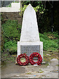 World War I MemorialMemorial · 5.7 mi
Explorer Tom World War I Memorial is locked in a silent, dramatic standoff with the nearest tree, which has grown so thick that it’s basically blocking the memorial’s view of the sky. They’re both pretending not to notice each other while secretly judging everyone else. Bring a map, get lost anyway, that's the fun.
_(40783618904).jpg/250px-Manx2_EC-ITP_Metro_EMA(5)_(40783618904).jpg "Photo: Rob Hodgkins, Wikimedia Commons · CC BY-SA 2.0") Manx2 Flight 7100Aviation accident · 6.4 mi
Manx2 Flight 7100Aviation accident · 6.4 miExplorer Tom Manx2 Flight 7100 is doing a bit of aerial limbo over County Cork. Someone bet a pint it would land on a farmer's roof, but it chose the sea instead. Bring a map, get lost anyway, that's the fun.
More historic places in County Cork · All of County Cork

What do you know about this place?Tap to add a comment or ask a question