What is recorded here
From the National Monuments Service (Archaeological Survey of Ireland) record CV030-009
The monument record does not grant public access. Check the route and ask the landowner before entering private land.
- What survives
- Recorded monument
Places near here
Photo credits
- National Inventory of Architectural Heritage
Explorer Tom Arnaghan North is a mysterious Cavan peak, likely hiding somewhere near Blacklion, waiting for curious hikers to find.
Scrabby Hill FortArchaeological place · 1677 ydExplorer Tom Scrabby Hill Fort sounds like it has a bit of character, perhaps named after someone who liked a rough time.
Lisraherty Bog WoodlandWood · 1.2 mi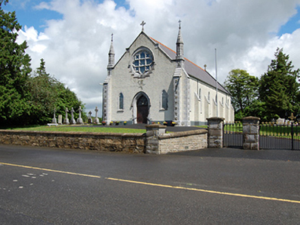 Church of the Holy FamilyChurch/chapel · 1.2 mi
Explorer Tom The Church of the Holy Family in Lough Gowna, built in 1904, boasts carved Celtic crosses on its Gothic Revival gables.
CastleBawn · 1.3 mi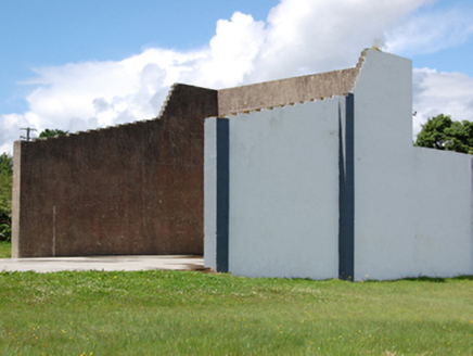 handball alley1.3 mi
Explorer Tom Scrabby’s handball alley from 1940 is still standing, which is rare. I wonder if anyone still bounces the ball against those rendered walls.
Cloone HouseCastle, unclassified · 1.5 miExplorer Tom This brick house stands where locals believe a castle once existed, though no other details or visible remains confirm that earlier structure's existence.
Scrabby IslandIslet · 1.6 miExplorer Tom Scrappy Island is an islet in County Cavan, likely part of that beautiful Irish landscape everyone wants to pin on their board.
Arnaghan SouthMountain / peak · 1.6 miExplorer Tom Arnaghan South sounds like a playful sibling in County Cavan, probably nestled among the scenic local landscapes.
Cornamucklagh WoodlandWood · 2.3 miExplorer Tom Cornamucklagh Woodland in County Cavan has a name that rolls off the tongue; I imagine the soil here is soft and welcoming to boots.
More archaeology and monuments in County Cavan · All of County Cavan
What do you know about this place?