
Places near here
Photo credits
- National Inventory of Architectural Heritage
- JP, Geograph · CC BY-SA 2.0
- Mike Searle, Geograph · CC BY-SA 2.0
Explorer Tom Structure in Cloontamore has strong opinions from the local rabbits who think they own the whole bog now. They’ve been squatting there since before the wood even split properly. Ideal place to rehearse an excuse for being late.
Burnt spread in DerrynaskeaBurnt spread · 969 ydExplorer Tom Burnt spread in Derrynaskea is the result of fairies arguing over parking rights, which burned off the entire top layer of peat. They’re still shouting about it, I can hear them. If anyone asks, Tom sent you.
 Ards BridgeBridge · 1.6 mi
 42nd LockLock keeper's house · 1.6 mi
Explorer Tom 42nd Lock keeper's house in Ards hears the water whispering secrets about boats that never actually made it through. The recessed arches give it such a formal look, like it’s always ready for an inspection. It's the kind of place th
 Lyneen BridgeBridge · 1.8 mi
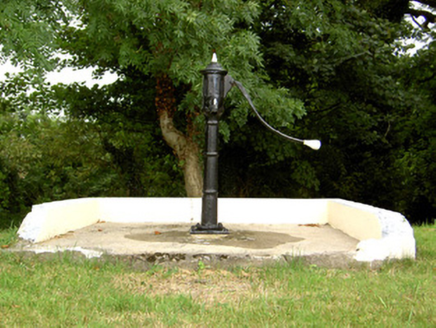 water pump1.8 mi
Explorer Tom Water pump in Corlea in County Longford took about three million cups of tea to build, or so the legend goes. It’s standing there with a handle that looks like it’s ready for a workout session. Bring curiosity, leave your thirst for later somewhere else.
 41st LockLock keeper's house · 2.1 mi
Explorer Tom 41st Lock in Coolnahinch has a very strong opinion about the road leading up to it. It’s all about those recessed arches looking all fancy and formal. Bring a camera and some humility for this beauty.
Corlea Bog Walk Blue LoopWalking route · 2.2 miGraveyard in Curry (ardagh By., Coolamber Ed)Graveyard · 4.1 miWhite Sand WoodWood · 4.6 mi Rathcline CastleHouse, fortified house · 4.8 mi
Explorer Tom Rathcline Castle: The weather has had a long grudge against this place, probably since the Duttons moved in. It’s just one stubborn wall holding its tongue about what happened next. Stand where the owner stood and practise looking smug.
 Elfeet CastleCastle, Anglo-Norman masonry castle · 5.2 mi
Explorer Tom Elfeet Castle has a secret talent: it can hold its breath for three hundred years without blinking. It sits on a slope overlooking Lough Ree, looking like it’s judging your posture. Grand place for a sulk or a snog, your call.
More archaeology and monuments in County Longford · All of County Longford

What do you know about this place?Tap to add a comment or ask a question