Places near here
Photo credits
- National Inventory of Architectural Heritage
- kevin higgins, Geograph · CC BY-SA 2.0
- kevin higgins, Wikimedia Commons · CC BY-SA 2.0
- The original uploader was Ww2censor at English Wikipedia ., Wikimedia Commons · CC BY-SA 2.0
- Mac McCarron, Geograph · CC BY-SA 2.0
- Andreas F. Borchert, Wikimedia Commons · CC BY-SA 4.0
- Maker named on the Wikimedia Commons picture page · CC BY-SA 3.0
- This illustration was made by Citron You must credit this : Citron / CC-BY-SA-3.0, Wikimedia Commons · CC BY-SA 3.0
- Jonathan Thacker, Geograph · CC BY-SA 2.0
- Hywel Williams, Geograph · CC BY-SA 2.0
 Sliabh gCuaHouse · 763 yd
Explorer Tom Sliabh gCua in Clooncogaile is a modest house that claims it survived a storm so nasty the clouds apologized for the damage. It sits there looking balanced and smug, like it knows something about the weather you don't. Tap the window gently to remind the roof who's boss.
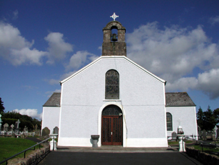 Saint Mary's Catholic ChurchOfficially recorded historic building · 982 yd
Explorer Tom Saint Mary's Catholic Church in Tooraneena is whispering secrets through its walls that probably aren’t about theology, I’d bet my boots. It survived Vatican II renovations, which means it’s seen some serious interior design chaos and lived to tell the tale. A
 Caherbrack HouseFarm house · 1.9 mi
Explorer Tom Caherbrack House is locked in a bitter feud with the next village over because they used the wrong colour paint on their fence in 1974, and nobody has spoken since then. It's still fuming about it.
 SeefinMountain / peak · 4.7 mi
Explorer Tom Seefin is where the rabbits go to judge your outfit and your life choices without saying a word. They look at your boots with such disappointment that you’ll want to change them immediately on the spot. Pretend it's yours and plan the housewarming.
 Standing StoneRuins · 4.9 mi
Explorer Tom This unnamed Standing Stone is haunted by a ghost who is far too lazy to actually do anything, so he just stands there looking confused. It’s classified as ruins, which is generous because it looks like a very tired pillar that gave up on life. Perfect detour when the satnav has a meltdown.
 KnockmealdownMountain / peak · 9.1 mi
Explorer Tom Knockmealdown stands on a county border and still manages to keep the actual highest point for Waterford. Its ridge divides Waterford from Tipperary, with routes from the Vee Gap and the Sugarloaf side. The Irish name may refer to the Muldowney family, though other explanations have been offered, so I will not invent a long-lost king just to sound impressive. The open slopes can look friendly from the road, then greet you with wind and bog. I would set off promising a quick loop and be sent back to check my map. Use a lawful established route, read the forecast and take proper navigation and clothes before climbing. Pause at the Vee and see how the ridge shapes both counties. A map line is neat; the mountain that carries it is anything but.
 Lady Louisa's WalkWalking route · 10 mi
Explorer Tom Lady Louisa's Walk would order extra ketchup and a side of attitude if it went to a chippy, demanding her chips be perfectly crispy and her tea scalding hot. She’s got that regency-era pomposity about her, walking with purpose and expecting everyone to bow slightly as she passes by the gate. If it rains, blame me.
 Cathedral10 mi
Explorer Tom Cathedral in Lismore smells like old prayers and expensive regret if you ask me. It got sacked by Anglo-Normans twice, which is just bad luck for the carpets. A good place to forget your phone for ten minutes.
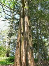 Dawn Redwood10 mi
Explorer Tom Dawn Redwood in County Waterford has that prehistoric vibe going on, like it’s seen dinosaurs and wasn’t impressed by them either. There’s a bird up top that refuses to leave, probably because the tree is its only valid excuse for napping. Visit, then text me what you think. I'll pretend to read it.
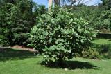 Delavay's magnolia10 mi
Explorer Tom Delavay's magnolia in County Waterford looks like it was bought at a very expensive auction by a cow with excellent taste. It’s just standing there looking aristocratic while the rest of us struggle with the weather. Snap one photo, then put the phone away and actually look.
 Ambrose Power MemorialMemorial · 10 mi
Explorer Tom Ambrose Power Memorial in County Waterford stands at a busy junction where traffic goes faster than his escape plan could ever hope to match. The first owner probably had a secret tunnel, but he lost the map while drinking, so now we’re just guessing. Get a photo with it before it gets a better agent who knows what to do with all that stone.
 The VeeViewpoint · 11 mi
Explorer Tom The Vee thinks the road leading to it is a bit of a wimp for being so straight and predictable all the time. It prefers to sit up here and judge everyone who drives too fast or takes selfies that don’t quite capture its majestic angle. Bring your nan along if you can, because she will absolutely know more about this hill than I ever will.
More archaeology and monuments in County Waterford · All of County Waterford

What do you know about this place?Tap to add a comment or ask a question