Places near here
Photo credits
- Mike Searle, Wikimedia Commons · CC BY-SA 2.0
- Jonathan Thacker, Geograph · Creative Commons Attribution-ShareAlike 2.0
- National Inventory of Architectural Heritage
- Mike Searle, Geograph · CC BY-SA 2.0
- dougf, Geograph · CC BY-SA 2.0
- El Gringo ( talk ) ( Uploads ), Wikimedia Commons · CC BY-SA 3.0
- Gordon Hatton, Wikimedia Commons · CC BY-SA 2.0
Explorer Tom Castle Rock caused such a massive row in the parish last Tuesday that three people are still not speaking to each other. Everyone has an opinion on whether it looks more like a castle or just a very angry boulder. Take a breath of that air, it's older than your car.
 Cloigtheach (Round Tower)Round tower · 996 yd
Explorer Tom Cloigtheach in Sleenoge has a unique hexagonal base that makes it look like it was built by someone who really liked geometry. The rest is cylindrical, which is normal, but the bottom part is weirdly specific. Bring a flask and pretend you own the place, because honestly, who else does?
 St Bartholomew's Church of Ireland ChurchChurch/chapel · 1024 yd
Explorer Tom St Bartholomew's in Sleenoge has a round tower that looks like it’s been standing there since the dawn of time. The church itself is Romanesque and fancy, so don’t be rude. Pick a spot from public ground and admire the detail!
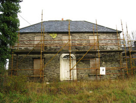 Tower ViewHouse · 1102 yd
Explorer Tom Tower View in Sleenoge is currently disused, which means it’s probably sleeping in past noon. It’s got a hipped roof and looks like it’s waiting for someone to tidy up its act. Wave if you see it!
 Fort RobertArchaeological place · 1.6 mi
Explorer Tom Fort Robert is an archaeological site where a prophecy said a dragon would land here in 1994, but it never did and everyone just forgot about it afterwards without making a fuss. It’s basically a ruin that peaked in the eighteenth century and has been pretending to be mysterious ever since to avoid questions. Bring biscuits, every good story needs biscuits.
Irish National Forestry FoundationNature reserve · 2.2 miExplorer Tom Irish National Forestry Foundation is a nature reserve that gets tipsy after three pints of rainwater. It will tell you secrets about the ringforts if you listen closely enough. Ten minutes here and you will have a yarn for the pub.
The GlenWood · 3.6 miExplorer Tom The Glen in County Cork is having a bit of a midlife crisis, whispering to the trees that replaced it that they're all just fancy shrubs with delusions of grandeur. It's got zero chill and the wind up there is absolutely rude about your haircut. Whisper a secret at it, it's kept worse.
 Tower (in Ruins)Bawn · 4.2 mi
Explorer Tom Tower in Ballynacarriga is just fragmentary bawn remains next to the main castle. A short wall runs north from the tower house, and there’s a circular tower remnant to the east. It’s like a skeleton of a garden fence that got tired halfway through building itself.
 Ballynacarriga CastleCastle, tower house · 4.2 mi
Explorer Tom Ballynacarriga Castle is a four-storey tower house overlooking the lough. It has a spiral stair, vaulted lobby, and murder hole. The top floor was used as a chapel later on. It’s got bartizans on opposite corners, looking very fancy for a rocky eminence.
Corran HillMountain / peak · 4.3 miExplorer Tom Corran Hill hides a message in its stones if you squint hard enough, mostly because someone carved 'I was here' in 1890 and no one has fixed it since. The letters are barely visible now, which only adds to the mystery of who exactly was complaining about the wind back then. Stand where the owner stood and practise looking smug.
 Kilmichael AmbushAmbush · 4.7 mi
Explorer Tom The Kilmichael Ambush has a secret talent for making you feel like you’re walking through a very aggressive history book that keeps popping up in your peripheral vision to check if you’re paying attention. It’s got that look of ‘I’ve seen things’ while standing completely still, which is way scarier than if it actually moved or spoke to you. Count the crows, then count again.
 Kilmichael Ambush SiteMonument · 4.7 mi
Explorer Tom Kilmichael Ambush Site in County Cork has a rivalry with every other ambush site because they all think theirs was the cleverest one ever pulled off. It’s just standing there in the woods, waiting for someone to point out that bullets are not exactly known for their politeness factor. Perfect spot to practise your best tour-guide voice.
More archaeology and monuments in County Cork · All of County Cork

What do you know about this place?Tap to add a comment or ask a question