
What is recorded here
From the National Monuments Service (Archaeological Survey of Ireland) record CO106-002
Places near here
Picture notes
- Mike Searle, Geograph · CC BY-SA 2.0
- Computer-made picture. It does not show this monument.
- Hywel Williams, Geograph · CC BY-SA 2.0
- National Inventory of Architectural Heritage
- MrCorman, Wikimedia Commons · CC BY-SA 4.0
- Mike Searle, Wikimedia Commons · CC BY-SA 2.0
- Computer-made picture. It does not show this walking route.
- Computer-made picture. It does not show this playground.
- Richard Webb, Geograph · CC BY-SA 2.0
- Computer-made picture. It does not show this mountain top.
 Kealkill stone circleVisitor information · 284 yd
 CairnCairn, radial-stone cairn · 307 ydComputer-made picture
Explorer Tom Cairn in Kealkill was excavated back in 1938, so it’s basically seen everything and lost some of its stones along the way. It’s part of a complex, which is fancy for 'group project'. Hum something sad nearby, it adds atmosphere.
 GallaunsStone circle, five-stone · 307 yd
Explorer Tom Gallauns in Kealkill are five stones doing a tight little circle on the bog shoulder. Go in good boots and better humour, because that bog is not your friend at all.
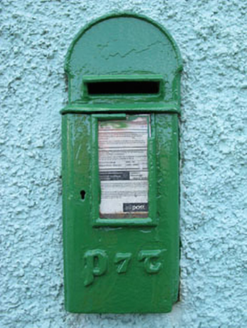 post box629 yd
Explorer Tom Post box in Breeny Beg is another iron beauty on Kealkill, hiding messages in its metal skin that only the postman understands. It’s an attractive addition to the street but feeling a bit left out by the plastic ones. Bring a pen and write your name on it.
 Carriganass BridgeBridge · 1045 yd
Explorer Tom Carriganass Bridge in Breeny Beg makes a weird creaking sound at night that sounds like a ghost stretching its legs. It’s been ferrying people since the eighteenth century and is tired. Go before the dark falls if you want to see it clearly!
 Carriganass CastleCastle · 1057 yd
Explorer Tom Carriganass Castle in County Cork was built by Dermot O'Sullivan Beare around 1540. Four storeys on a rocky base! Take a picture for me if you can spot the O'Sullivan Clan's old swagger.
Carriganass Castle (in Ruins)Castle, tower house · 1057 ydExplorer Tom Carriganass Castle stands on the north bank of the Owvane river with a commanding view. A goat once ruled it and left only a hoofprint as evidence. Tell it a joke, it's been a long time since anyone did.
 Bulls PocketWalking route · 1.4 miComputer-made picture
 St Colum's PlaygroundChildren's playground · 1.7 miComputer-made picture
 Glanbannoo WalkWalking route · 3.9 miComputer-made picture
 Coomhola MountainMountain / peak · 4.2 mi
 Maughanaclea Hills E TopMountain / peak · 4.4 miComputer-made picture
More archaeology and monuments in County Cork · All of County Cork

What do you know about this place?Tap to add a comment or ask a question