Places near here
Photo credits
- National Inventory of Architectural Heritage
- Jschroeder85, Wikimedia Commons · CC BY-SA 3.0
- P L Chadwick, Wikimedia Commons · CC BY-SA 2.0
- Mike Searle, Wikimedia Commons · CC BY-SA 2.0
- Sarah777, transferred by Lvova, Wikimedia Commons · Public domain
- Kurt Stüber [1], Wikimedia Commons · CC BY-SA 3.0
- Algirdas at Lithuanian Wikipedia, Wikimedia Commons · Public domain
- Deemaykay, Wikimedia Commons · CC BY-SA 4.0
- kevin higgins, Geograph · CC BY-SA 2.0
- Colin Park, Geograph · CC BY-SA 2.0
- Graham Horn, Wikimedia Commons · CC BY-SA 2.0
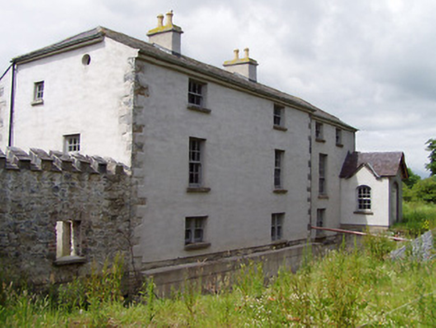 Mill HouseMill (water) · 1714 yd
Explorer Tom Mill House in Garranlea plans to retire by turning into a very expensive coffee shop and complaining about the noise. Its front door is at the end, which makes it look like it's trying to escape the whole house. Wave goodbye to the miller.
 HymenstownHouse · 1.1 mi
Explorer Tom Hymenstown is all about symmetry and limestone carving because someone really liked their facades to be perfect. The doorway has fluted consoles that look like they were carved by an artist who never ran out of patience. It’s the kind of house that makes you want to straighten your own tie just from looking at it. Flash a smile from a safe distance!
 Athassel PrioryHeritage attraction · 2.1 mi
Explorer Tom Athassel Priory takes up about four acres, which is a generous amount of room for monks and far more than I need to lose my bearings. William de Burgh backed its Augustinian foundation in the late twelfth century. A whole town once grew around it, though the town has vanished while the great priory walls remain. Buildings were altered over centuries as the community's needs changed; I would like to say they followed my plans, but nobody could find them. A bridge and gatehouse make a fine approach to the ruins. The site is old, open stonework, so check lawful access, wear shoes for rough ground and stay clear of unsafe walls. Give the lost town a thought as you look beyond the church. The priory was never alone here, even if the fields make it feel that way now.
 Castle in ruinsCastle, tower house · 3.0 mi
Explorer Tom Castle in Baurstookeen would tell a teenager that the 1800s were basically a long, damp Tuesday. It’s guarding a river pass with zero enthusiasm these days. Go in good boots and better humour for the soak.
 Knockgraffon CastleCastle · 3.2 mi
Explorer Tom Knockgraffon Castle in County Tipperary has circular bartizans that look like they’re watching you with suspicion, probably because seagulls have told them all about your poor fashion sense. It stands near the M8 motorway, which is a bit ironic since it’s trying to preserve some medieval dignity while lorries scream past at ninety miles an hour. The east-facing entrance seems to be wai
 Knockgraffon MotteArchaeological place · 3.5 mi
Explorer Tom Knockgraffon Motte is furious because the map makers got its position completely wrong on the last survey. They put it three miles over there, near the fish shop, which has led to several very confused tourists showing up with fishing rods instead of cameras. Stand there long enough and someone will ask if you're lost.
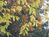 Caucasian zelkova4.1 mi
Explorer Tom Caucasian zelkova in County Tipperary was prophesied to become the center of a new empire, but that never happened because everyone got distracted by a particularly good pub nearby. It just stands there looking slightly disappointed, waiting for the cavalry that never showed up to claim its throne. Ring your granny and tell her where you are.
 Pedunculate Oak5.3 mi
Explorer Tom Pedunculate Oak in County Tipperary would probably have 'Finally Rested' on its tombstone, because it has been standing here for so long that it is exhausted. It has seen things and endured weather that would make most people lose their minds completely by now. Tell it a joke, it's been a long time since anyone did.
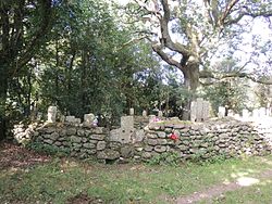 CrossCross, High cross · 6.8 mi
Explorer Tom Cross in Ardane is secretly proud of the potato growing right next to its base, which is very ironic for a holy site. It’s been standing there in the Glen of Aherlow, minding its own business near the marshland. Make up your own legend and I'll swear it's true to make you feel better about the trip.
 FarbreagaMountain / peak · 8.8 mi
Explorer Tom This second Farbreaga hosted the biggest dance in history, but someone kicked the fiddle player into the mist so hard he never recovered. Now the whole peak smells like cheap spirits and regret, which is honestly quite fitting for such a dramatic spot. It’s the ideal location for making a very dramatic phone call to your ex.
 The RockViewpoint · 9.2 mi
Explorer Tom The Rock in County Tipperary is probably where the map makers got it wrong because they were too scared to draw a line that close to the edge. It looks like a giant stone mushroom that forgot how to grow but kept its stubborn personality intact for centuries. Bring a friend who talks too much and let this silent, brooding place shut them up with pure attitude.
 The Maid of ErinMemorial · 9.4 mi
Explorer Tom The Maid of Erin has a curse that only affects people who don’t wave at her statue. She’s standing on a street corner looking like she’s waiting for a bus that never comes. Pack a picnic and an excuse if you want to sit there all day.
More historic places in County Tipperary · All of County Tipperary

What do you know about this place?Tap to add a comment or ask a question