
Places near here
Photo credits
- Kieran Campbell, Geograph · Creative Commons Attribution-ShareAlike 2.0
- Digital Eye, Wikimedia Commons · CC BY-SA 4.0
- DarranRaff, Wikimedia Commons · CC BY-SA 4.0
- Eric Jones, Geograph · CC BY-SA 2.0
- TommyMurf, Wikimedia Commons · CC BY-SA 4.0
- GilPe, Wikimedia Commons · CC BY-SA 4.0
- Garry Dickinson, Geograph · CC BY-SA 2.0
 Saint Mary's Church (Ballymascanlan)Church/chapel · 31 yd
Explorer Tom Saint Mary's Church in Ballymascanlan would tell its younger self to stop worrying about the stained glass and start…
 Saint Mary's Parochial HallOfficially recorded historic building · 195 yd
Explorer Tom Saint Mary's Parochial Hall was mocked by a bad poem about its brickwork that still haunts the village pub. Nobody…
 DolmenPortal tomb · 1065 yd
Explorer Tom Dolmen in Proleek has a ghost that’s too lazy to haunt it properly. The roof stone is massive and looks like it fell…
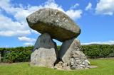 Proleek DolmenArchaeological place · 1066 yd
Explorer Tom Proleek Dolmen balances a mighty stone in a way that makes me suspicious of my own wobbly garden wall. The portal tomb…
 Giants GraveWedge tomb · 1086 yd
Explorer Tom Giants Grave in Proleek is basically run by a dog who thinks he owns the place. The wedge tomb is gone now, but the…
 Battle of FaughartMajor battlefield · 1.4 mi
Explorer Tom The Battle of Faughart happened here in 1318, and its least favourite visitor is definitely anyone bringing a picnic…
 Soldiers' PointHeadland · 1.6 mi
Explorer Tom Greenore Point handles its nosey neighbours by simply ignoring them and pointing at the mountains across the water…
 The Round MountainMountain / peak · 2.3 mi
Explorer Tom The Round Mountain has an unlikely celebrity friend who visits every year to hide from their ex. It’s basically the…
 Louth County MuseumMuseum · 2.4 mi
Explorer Tom Louth County Museum occupies an old Dundalk warehouse and somehow fits a county's long history inside without stacking…
 Maid of ErinMemorial · 2.5 mi
Explorer Tom Maid of Erin isn’t actually a maid; she’s just a very dramatic statue pretending to be pure while judging your outfit…
 Feede MountainMountain / peak · 2.9 mi
Explorer Tom There was a love story that went badly wrong next to Feede Mountain because one person forgot to bring an umbrella and…
 CastleCastle, tower house · 3.0 mi
Explorer Tom Castle in Castletown ended up here because Richard Bellew got confused about which side of town was cool. It’s a tower…
More archaeology and monuments in County Louth · All of County Louth

What do you know about this place?Tap to add a comment or ask a question