What is recorded here
Church in Ballymagarvey has lost its nave but kept its chancel: the congregation’s end has disappeared, while the preacher’s end stands firm. Even the building couldn’t get him to finish.
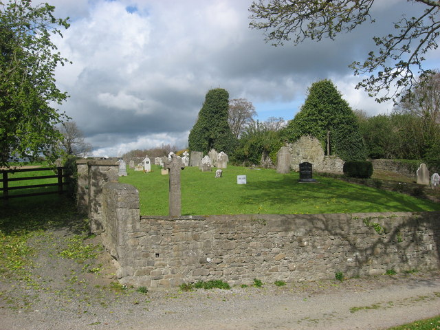
Situated on a bluff overlooking the valley of the W-E Nanny River, with a WNW-ESE section of the stream c. 50m to the NE. A church at Balimgarvey is listed in the ecclesiastical taxation (1302-06) of Pope Nicholas IV (Cal. doc. Ire., 5, 252). Ussher (1622) describes the church and chancel of Balmagarvey as in good repair (Erlington 1847-64, 1, lxv). According to Dopping (1682-5) the church was unrepaired since 1641 (Ellison 1971, 34). The parish church of Ballymagarvey is within a subrectangular graveyard (dims c. 45m E-W; c. 22m N-S at E to c. 30m N-S at W) defined by masonry walls and has headstones dating from c. 1757 to 1976. This is a divided nave (ext. dims 13.3m E-W; c. 7m N-S) and chancel (ext. dims 8.2m E-W; 6.3m N-S) structure but only the overgrown W gable with its belfry and the overgrown chancel survive (total L 21.5m). The pointed chancel arch (Wth 2m) is original and the pointed E window (Wth 1.35m) has two cusped ogee-headed lights with a quatrefoil over them but it is presently obscured by ivy growth. A large fragment of a rectangular sandstone font (dims 0.6m x 0.6m; max. H 0.5m) with chamfered angles and a circular basin (diam. 0.49m; D 0.27m) is outside the E gable. The side-panels are D-shaped as the stone morphs into a circular form at the bottom (Roe 1968, 109-10). The Balrath wayside cross (ME032-010----) was moved from its original position c. 270m to the ENE beside the old Kentstown to Duleek road and is now displayed at the SE angle of the graveyard. It is a small Celtic cross (H 1.75m; span 0.55m) without a ring which has a crucifixion on the W face and a Pietá on the E, executed in false relief (King 1984, 105). See the attached view from the SE, and view of the E window
Compiled by: Michael Moore
Date of revision: 23 January 2015
Situated on a bluff overlooking the valley of the W-E Nanny River, with a WNW-ESE section of the stream c. 50m to the NE. A church at Balimgarvey is listed in the ecclesiastical taxation (1302-06) of Pope Nicholas IV (Cal. doc. Ire., 5, 252). Ussher (1622) describes the church and chancel of Balmagarvey as in good repair (Erlington 1847-64, 1, lxv). According to Dopping (1682-5) the church was unrepaired since…
From the National Monuments Service (Archaeological Survey of Ireland) record ME032-009
The monument record does not grant public access. Check the route and ask the landowner before entering private land.
- What survives
- Recorded monument
Places near here
Photo credits
- National Inventory of Architectural Heritage
- JP, Geograph · CC BY-SA 2.0
- Kieran Campbell, Wikimedia Commons · CC BY-SA 2.0
- Malene Thyssen, Wikimedia Commons · CC BY-SA 3.0
- Kieran Campbell, Geograph · Creative Commons Attribution-ShareAlike 2.0
- Willow, Wikimedia Commons · CC BY 2.5
- Kieran Campbell, Geograph · CC BY-SA 2.0
- John M, Wikimedia Commons · CC BY-SA 2.0
- Patrick Brown, Wikimedia Commons · CC BY-SA 2.0
- Anthony Foster, Geograph · CC BY-SA 2.0
- Neil Forrester, Co.Meath, Ireland. http://neil.forrester.ie, Wikimedia Commons · CC BY 3.0
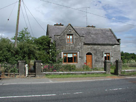 Stone LodgeRic barracks · 244 yd
 Balrath Post OfficePost office · 258 yd
 CrossCross, Wayside cross · 302 yd
 European Beech1659 yd
 Grave YardGraveyard · 1.1 mi
 European ash1.6 mi
 Athcarne CastleCastle, tower house · 2.0 mi
 CastleCastle, tower house · 2.8 mi
 Brú na Bóinne Visitors CentreVisitor information · 5.2 mi
 Hill of TaraVisitor information · 5.6 mi
 Saint Patrick'sMemorial · 5.7 mi
 Battle of Tara HillBattle · 5.9 mi
More historic places in County Meath · All of County Meath
What do you know about this place?