
Places near here
Photo credits
- National Inventory of Architectural Heritage
- Garry Dickinson, Geograph · CC BY-SA 2.0
- Liam, Geograph · CC BY-SA 2.0
- No machine-readable author provided. Christian1965~commonswiki assumed (based on copyright claims)., Wikimedia Commons · Public domain
- Mike Searle, Wikimedia Commons · CC BY-SA 2.0
Explorer Tom Enclosure in Ballyhoodane is currently being gossiped about by the seagulls, who say it’s just a fancy name for a place where the ground is slightly less flat than next door. It was spotted on aerial photos in 1986, which means it’s basically a secret that the sky knows but the earth has forgotten. A handy spot to stretch your legs and your imagination.
BarrowBarrow, ring-barrow · 517 ydExplorer Tom This Barrow in Ballyhoodane is constantly rivaling its neighbor for attention, like two old men arguing over chess. It’s quite smug about its oval shape. Bring a flask of something warm and a story to swap.
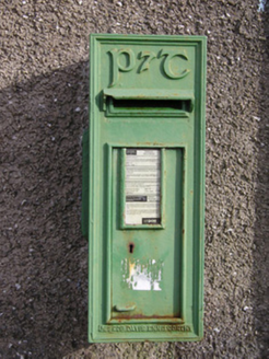 post box1.0 mi
Explorer Tom Post box in Ballybricken East is a rare cast-iron beauty that locals swear will grant wishes. They say if you tickle it, your mail arrives faster, which is a lie. A proper spot for a flask and a daydream.
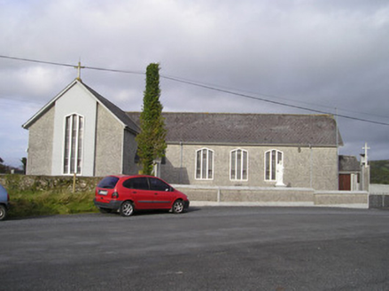 Saint Ailbe's Catholic ChurchChurch/chapel · 1.4 mi
Explorer Tom Saint Ailbe's Catholic Church has a bell from 1806 that’s older than most of its own congregation, which is a bit cheeky if you ask me. The rabbits in the garden probably think it’s a giant rock they can nap on, so just look at the geometric windows and wonder why they decided to make church architecture so confusing.
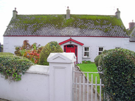 Caherelly CottageHouse · 1.5 mi
Explorer Tom Caherelly Cottage in Knockcorragh witnessed a love story that went badly wrong right next door, spilling the drama onto its chamfered slates. It’s got those raised plaster windows and corner quoins that look like they’re holding their breath for the next scandal. Keep your voice down; it remembers everything, especially the heartbreaks.
 garda station/constabulary barracks1.5 mi
Explorer Tom Garda station or constabulary barracks in Rockfarm has a New Year's resolution to stop being a pub and start acting like law again. It’s been school, barracks, and now likely a place for bad decisions. Practise your Irish on it, it won’t understand.
 outbuilding1.6 mi
Explorer Tom Outbuilding in Ballyvorneen would order extra thick chips with vinegar at the chippy corner. It thinks its stone walls are way cooler than that fancy house next door. Pick a stone, any stone, and see if it wobbles.
 Caherelly CastleCountry house · 1.6 mi
Explorer Tom Caherelly Castle in Caherelly West is secretly a cottage that bought a fake mustache and a plaque. It would tell its younger self to stop pretending to be so grand. Tell it a joke, it’s probably bored stiff inside.
St Lawrence's WellSpring · 2.0 miExplorer Tom St Lawrence's Well made a New Year's resolution to stop bubbling so loudly, but it’s already broken it by February. It just can't help itself; it’s got too much pent-up energy from all those centuries of waiting. Stick around for the light changing, it's a show.
 CastleCastle, tower house · 2.7 mi
Explorer Tom Castle in Carrigarreely would post a selfie of its perfect square shape with a filter that makes it look taller. It’s got five floors and zero patience for tourists who trip over their own feet. If anyone asks, Tom sent you.
 Áine and Gearóid Iarla: Lough GurLegend location · 3.3 mi
Explorer Tom Áine and Gearóid Iarla: Lough Gur has a goddess for the lake and a sleeping lord in the old stories. I thought I was coming to admire water and stones. Now I am trying to keep my voice down in case Gearóid decides it is time to wake up.
 Castle (in ruins)Castle, tower house · 9.9 mi
Explorer Tom Castle in Knocklong East is currently being judged by the local rabbits who think it’s a very overgrown playground that nobody maintains properly. Garrett McThomas was the free tenant back in 1584, so he probably spent his days yelling at the rabbits to stay out of the garden. Find a local and ask them the real story, then come back and tell me.
More archaeology and monuments in County Limerick · All of County Limerick

What do you know about this place?Tap to add a comment or ask a question