DDiscover AloneMapAbout

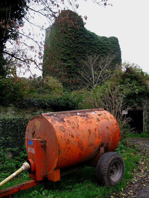
Castle in Carrigarreely

Castle, tower house
Castle in Carrigarreely
Carrigarreely Castle
Photo: Liam, Geograph · CC BY-SA 2.0 · Report the wrong picture

What is recorded here

Carrigarreely Castle described in 1840 as follows; 'This castle is placed on a limestone rock, about 2 chains (40m) in diameter and 20 feet (6.1m) high. It retains the appearance of a strong building, and is about 60 feet (18.3m) high and 24 feet (7.3m) wide, being square' (OSNB Caherconlish Parish, 305). The Ordnance…

Read the whole record
Carrigarreely Castle described in 1840 as follows; 'This castle is placed on a limestone rock, about 2 chains (40m) in diameter and 20 feet (6.1m) high. It retains the appearance of a strong building, and is about 60 feet (18.3m) high and 24 feet (7.3m) wide, being square' (OSNB Caherconlish Parish, 305). The Ordnance Survey Letters recorded that the 'walls are perfect. It measures nineteen feet eight inches by fourteen and a half feet in the clear and has five stories; the fourth floor is arched underneath. The height of the structure is about seventy feet and the thickness of the walls about six and a half feet' (OSL Caherconlish Parish, 117-8). The 1654-56 Civil Survey of Limerick recorded that the Lord of Brittas was the owner of 'a Castle, and a bawen' (Simington 1938, 64). Westropp (1906-07, 96) recorded the following details about Carrigareely; 'Fitzgerald calls it Carrigifarrioyla, "the O'Farrellys' rock," and says it was built by the Bourkes and occupied by the O'Dalys (vol. ii., p. 286) ; O'Donovan denies this, and says it was Carraig Fearghaill, Farrell's Rock (O.S.L., 8, p. 408). 1558 Sussex on his progress was entertained with drink by W. Burke as he passed the C[astle]. of Carree Kerellois (Carew, i., p. 274). 1567 Pardon to Theo. Bourke of Carrygkyrily (Fi., 1050). 1576 Theo, died in possession of Karriarilie or Karrigkyrely (Inq. Exch., 9). 1655 Carrigiriell held by Lord Brittas. C[astle]. shown (D.S.A., 14, 18; C.S., xxi., p. 10). Fabric - It stood on a rock 20 feet [6m] high, and was fairly perfect, being about 70 feet [21.3m] high, with five stories, the fourth floor over a vault. It measured 19 feet 8 inches [6m], by 14½ feet [4.4m] inside. Walls 6½ feet [2m] thick (O.S.L., 8, p. 408)'. Tower-house like castle depicted on the 17th century Down Survey map of Clanwilliam Barony (Hib. Reg.) and the parish map of Caherconlish (NLI, MS. 718). Castle described by Salter (2004, 71) as ;'This tower measuring 10.6m by 8.2m lies on a rock with a sheer drop of 6m on the west side and a drop of 1 .5m on the south, so that a two storey range later added on that side had an upper storey almost at the same height as the lowest storey of the main tower. This end contains a tier of mural chambers over the entrance passage and there is a spiral staircase in the SW corner. Not much remains of the main tower above the vault over the third storey. The west wall contains a fireplace on the second storey and a latrine reached from the staircase on the third storey'. Classified by Donnelly (1999, 37) as a Type 1A Tower House which is a castle with a 'ground floor entrance to the building leads to an entrance lobby. To one side of the entrance lobby is a doorway leading to a spiral staircase set in a corner of the building. To the other side is a doorway leading into a small chamber - the subsidiary chamber. The entrance lobby provides a direct route of access through to the main chamber'.

From the National Monuments Service (Archaeological Survey of Ireland) record LI014-033

The monument record does not grant public access. Check the route and ask the landowner before entering private land.

What do you know about this place?Tap to add a comment or ask a question

What you write will be public.

Places near here

Photo credits
  • National Inventory of Architectural Heritage
  • Ronnie Nijboer, Wikimedia Commons · CC0
  • Kmcnamee, Wikimedia Commons · CC BY-SA 4.0
  • Golfing in Ireland; photographer not stated, Source publisher
  • Garry Dickinson, Geograph · CC BY-SA 2.0
  • Mike Searle, Wikimedia Commons · CC BY-SA 2.0
Site of Killanoher Burial GroundChildren's burial ground · 738 yd

Explorer Tom Site of Killanoher Burial Ground is guarded by one very determined bird that refuses to leave despite everyone telling…

Enclosure in SkahardEnclosure · 1130 yd

Explorer Tom Enclosure in Skahard is feuding with the rain again. It’s so angry about the puddles it might actually grow legs and…

Highpark HouseCountry house · 1442 yd

Explorer Tom Highpark House in Highpark is where a love story went badly wrong right next to it, probably because the symmetrical…

St Lawrence's WellSpring · 1.0 mi

Explorer Tom St Lawrence's Well made a New Year's resolution to stop bubbling so loudly, but it’s already broken it by February. It…
Caherconlish ChurchChurch/chapel, mausoleum · 1.1 mi

Explorer Tom Caherconlish Church in Caherconlish would be a disaster on a reality show because it’s falling apart slowly. It’s got…
Wych Elm1.3 mi

Explorer Tom Wych Elm in County Limerick is in a serious feud with the rain because it keeps getting wet on purpose. It thinks the…

Caherline GAA pitchGAA ground · 1.6 miBallyneety Golf ClubGolf course · 2.6 miCastleCastle, motte and bailey · 3.4 mi

Explorer Tom The motte at Brittas is losing a rivalry with a more famous place because it got levelled by a farmer. Sit on a wall…

Graveyard in AbingtonGraveyard · 3.6 mi

Explorer Tom Graveyard in Abington has a retirement plan involving just standing there on a ridge and doing absolutely nothing. It…

Rockstown Castle (in ruins)Castle, tower house · 3.7 mi

Explorer Tom Rockstown Castle is perched high like a proud peacock on its limestone rock. A cow once tried to buy it, but the price…

Skool HillMountain / peak · 4.3 mi

Explorer Tom Skool Hill in County Limerick has a New Year's resolution to stop being so steep, but it’s already broken it by January…

More castles and forts in County Limerick · All of County Limerick

Add to this placeAdd a picture Add a detailed tip Add a story

Explore the map1,095,414 places to discover

Next place · or swipeSite of Killanoher Burial Ground