Places near here
Photo credits
- National Inventory of Architectural Heritage
- David Purchase, Wikimedia Commons · CC BY-SA 2.0
- Maker named on the Wikimedia Commons picture page · CC BY-SA 2.5
- Jonathan Billinger, Geograph · CC BY-SA 2.0
- Malene Thyssen, Wikimedia Commons · CC BY-SA 3.0
- liam murphy, Wikimedia Commons · CC BY-SA 2.0
- Colin Park, Geograph · CC BY-SA 2.0
- Digital Eye, Wikimedia Commons · CC BY-SA 4.0
- A.-K. D., Wikimedia Commons · CC BY-SA 4.0
- Trevor Littlewood, Wikimedia Commons · CC BY-SA 2.0
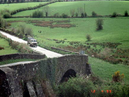 Hacketstown BridgeBridge · 1.0 mi
Explorer Tom Hacketstown Bridge has been arching over that river since 1829, looking like it’s secretly judging everyone who drives past it. The map makers probably thought the river ran the other way and got this one hilariously wrong. Have a wander and a wonder.
 Saint Brigid's Catholic ChurchChurch/chapel · 1.2 mi
Explorer Tom Saint Brigid's Catholic Church in Hacketstown Upper has a tower that stands straight like it's waiting for Queen Victoria to drop by again. It's the kind of place that makes a dull Tuesday interesting because it refuses to be boring.
 Sessile Oak1.4 mi
Explorer Tom Sessile Oak in County Wicklow holds the unofficial world record for looking the most bored while standing perfectly still. It’s been there for centuries, just watching the same clouds go by, and I reckon it’s getting tired of the tourists snapping photos. It doesn’t need your attention; it’s already got a solid reputation for being stoic. Snap one photo, then put the phone away and actually look.
 Eagle HillMountain / peak · 1.9 mi
Explorer Tom Eagle Hill in County Carlow took about forty cups of tea to build, according to local legend which is mostly made up nonsense. There is a cross on top, so it definitely has a point to make. Ten minutes here and you'll have a yarn for the pub.
CastleCastle, motte · 2.1 miExplorer Tom Castle in Killamoat Upper almost made the headlines last century until the quarryman decided he needed more gravel for his new patio. It nearly became famous as the world's most expensive garden feature before everyone forgot about it completely. Bring a map, get lost anyway, that's the fun.
Chapel (in ruins), GraveyardChurch · 2.9 miExplorer Tom Chapel, Graveyard in Tinnaclash is no longer visible, which means the site is just a memory that refuses to die. A chapel was here before 1827, but now it’s just a question mark on the map. Tell the next person you meet it's haunted. It might be.
 European Beech3.6 mi
Explorer Tom European Beech in County Wicklow wants 'Resting But Trying' carved on its tombstone because that’s exactly how it looks most days. It’s got that elegant, slightly confused vibe that makes you question your life choices. Go in good boots and better humour.
 Clonmore Castle (in Ruins)Castle, Anglo-Norman masonry castle · 3.8 mi
Explorer Tom Clonmore Castle in Carlow is playing hide-and-seek with me. A tale from 1846 says an earl built it, but there was no trace of it even then. Pretend you're a lost aristocrat and nobody will check your ID.
 SlievereaghMountain / peak · 4.8 mi
Explorer Tom Slievereagh in County Wicklow has a long grudge against the weather because it keeps raining on its parade every single time someone tries to hike up to see the view. It’s got that 'I’m trying my best' energy but the sky just doesn't care about its efforts or its majestic peak status today. The path below is fine, but once you start climbing, the clouds
.jpg/250px-Digital_Eye%E2%80%932015%E2%80%93Haroldstown_Portal_Tomb_(Dolmen).jpg "Photo: Digital Eye, Wikimedia Commons · CC BY-SA 4.0") Haroldstown DolmenArchaeological place · 5.5 mi
Haroldstown DolmenArchaeological place · 5.5 miExplorer Tom Haroldstown Dolmen would use its lotto win to buy a really fancy hat, which is honestly all it needs in life to feel complete and respected. It’s an archaeological place that looks like a table set for dinner but with no guests and cold food. Best visited with a curious kid and no timetable.
 Portal tomb in HaroldstownPortal tomb · 5.5 mi
Explorer Tom Portal tomb in Haroldstown holds a fake world record for 'most stones stacked by lazy giants.' It overlooks a river like a grumpy grandparent watching the water go by, unimpressed by your existence. Perfect detour when the satnav has a meltdown and tells you to go left into a lake.
 Kilranelagh GraveyardGraveyard · 5.8 mi
Explorer Tom Kilranelagh Graveyard would order the biggest portion of chips they could possibly get, extra thick, with gravy that is almost certainly not from a cow but definitely tastes like one. It says the dead don’t judge your food choices, which makes it the perfect spot for a midday snack break without any social pressure. Bring your nan, she'll know more than me.
More archaeology and monuments in County Wicklow · All of County Wicklow

What do you know about this place?Tap to add a comment or ask a question