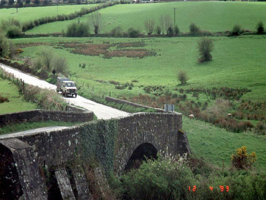
What is recorded here
Single-arch road bridge over river, dated 1829, with cut stone voussoirs and coping.
From the Buildings of Ireland (National Inventory of Architectural Heritage) record 10400201
This does not grant access. Most recorded buildings are privately owned; view them only from public ground unless the owner allows entry.
Places near here
Photo credits
- Smirkybec, Wikimedia Commons · CC BY-SA 4.0
- David Purchase, Wikimedia Commons · CC BY-SA 2.0
- Jonathan Billinger, Geograph · CC BY-SA 2.0
- Maker named on the Wikimedia Commons picture page · CC BY-SA 2.5
- liam murphy, Wikimedia Commons · CC BY-SA 2.0
- Malene Thyssen, Wikimedia Commons · CC BY-SA 3.0
- Digital Eye, Wikimedia Commons · CC BY-SA 4.0
- A.-K. D., Wikimedia Commons · CC BY-SA 4.0
 Church of Saint John the Baptist (Hacketstown)Church/chapel · 530 yd
 Saint Brigid's Catholic ChurchChurch/chapel · 744 yd
 Eagle HillMountain / peak · 1.1 mi
 Sessile Oak1.9 miChapel (in ruins), GraveyardChurch · 2.7 mi
 Clonmore Castle (in Ruins)Castle, Anglo-Norman masonry castle · 2.9 miClonmore MoatCastle, motte and bailey · 2.9 mi
 European Beech3.3 miChurch (in ruins), GraveyardChurch · 4.4 miBallycumber HillMountain / peak · 4.4 mi
.jpg/250px-Digital_Eye%E2%80%932015%E2%80%93Haroldstown_Portal_Tomb_(Dolmen).jpg "Photo: Digital Eye, Wikimedia Commons · CC BY-SA 4.0") Haroldstown DolmenArchaeological place · 4.5 mi
Haroldstown DolmenArchaeological place · 4.5 mi Portal tomb in HaroldstownPortal tomb · 4.5 mi
More historic places in County Carlow · All of County Carlow
What do you know about this place?