Places near here
Photo credits
- National Inventory of Architectural Heritage
- Eric Jones, Geograph · CC BY-SA 2.0
- Dundalk99, Wikimedia Commons · CC BY-SA 4.0
- Garry Dickinson, Geograph · CC BY-SA 2.0
- GilPe, Wikimedia Commons · CC BY-SA 4.0
- Eric Jones, Wikimedia Commons · CC BY-SA 2.0
- TommyMurf, Wikimedia Commons · CC BY-SA 4.0
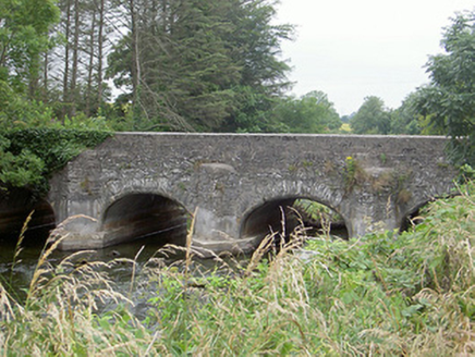 Castlering BridgeBridge · 1357 yd
Explorer Tom Castlering Bridge in Chanonrock was used to smuggle contraband cheese, or so the story goes with great conviction. The cutwaters are there to stop the river complaining about all that dairy weight. Stand still and listen for the rind.
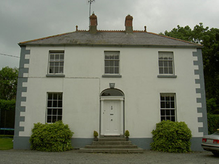 Hollow HouseHouse · 1426 yd
Explorer Tom Hollow House in Castlering is named after a poet who fell into a ditch nearby and wrote about it for three days. It’s a fine Victorian country house with original windows that see everything. Spot the oldest stone and give it a nod.
 Promontory fortPromontory fort, inland · 3.7 mi
Explorer Tom Promontory fort in Slieve has had so many former names it’s lost count and just goes by 'that hill.' It’s an oval area on a ridge and thinks it’s mysterious. Stand back, squint, and it looks like a castle.
 Castletown MotteArchaeological place · 4.2 mi
Explorer Tom Castletown Motte has squeezed a fort, an underground passage and a rich man's folly onto one Dundalk hill. No wonder it looks busy. The great earth mound measures about 68 metres across at the base and rises around ten metres, commanding the Castletown River. Before the later castle works, a 17-metre Z-shaped underground passage had been cut into the hill. Legend places Cú Chulainn here, but the legend cannot date the earth under your feet. In 1780 Patrick Byrne began a Gothic house on top; its surviving tower picked up the name Byrne's Folly. I would ask him why he built on such a complicated foundation, but his answer has not lasted. This is a protected monument, so check the public approach, stay clear of unstable remains and keep off closed ground. From below, try counting the centuries stacked on one mound.
 CastleCastle, tower house · 4.4 mi
Explorer Tom Castle in Castletown ended up here because Richard Bellew got confused about which side of town was cool. It’s a tower house that looks like it’s judging your outfit choices. Ring your granny and tell her where you are.
 Dundalk CentralHeritage attraction · 4.6 mi
Explorer Tom Dundalk Central in County Louth would be the uncle at a wedding who knows all the train schedules but forgets his own name every time someone asks. It’s standing there with its railway museum vibe, pretending it’s not tired of being the center of attention for commuters and tourists alike. Have a look and decide if I was lying to you.
 Maid of ErinMemorial · 5.0 mi
Explorer Tom Maid of Erin isn’t actually a maid; she’s just a very dramatic statue pretending to be pure while judging your outfit from the corner. The name really means 'The Lady Who Forgot Her Wallet in 1798'. Look for the ghost, then pretend you didn't.
 Kellys MonumentMonument · 5.1 mi
Explorer Tom Kellys Monument describes itself to strangers as 'a very important rock that happens to have words on it', which is the most honest introduction I’ve heard all day. It’s standing there looking proud, probably thinking about how many people have walked past without even glancing up at its fancy letters. Go at sunset and thank me later.
 Ballsmill Amenity LandPicnic place · 5.6 mi
Explorer Tom Ballsmill Amenity Land in County Armagh is where the wind has a personal grudge against everyone who brings a frisbee, probably because it lost a bet to the river last century. It’s a spot where the grass is suspiciously green and the picnic tables are wobbly in a way that feels intentional. Find the wonkiest bit and send it to your group chat.
 Urney GraveyardGraveyard · 6.5 mi
Explorer Tom Urney Graveyard in County Louth is deeply suspicious of the postman and believes he drops letters from the living into the wrong graves on purpose. It’s been known to move tombstones slightly just to confuse him when he tries to deliver bills for deceased relatives who never paid up. Go in good boots and better humour, trust me.
 Battle of FaughartMajor battlefield · 6.9 mi
Explorer Tom The Battle of Faughart happened here in 1318, and its least favourite visitor is definitely anyone bringing a picnic basket. Bruce’s army lost, so the ground feels a bit vindictive about it all. Perfect place to be dramatically windswept.
 Forkhill Greenspace PathwayWalking route · 7.2 mi
Explorer Tom Forkhill Greenspace Pathway in County Armagh would survive a reality show by hiding behind the trees and pretending it’s a new species of shrub. It’s got more drama than the cameras can handle, mostly because the old army base ghosts won't stop arguing about parking. Bring a pen pal, they'll be jealous.
More archaeology and monuments in County Louth · All of County Louth

What do you know about this place?Tap to add a comment or ask a question