
What is recorded here
From the National Monuments Service (Archaeological Survey of Ireland) record CV039-004
Places near here
Picture notes
- Computer-made picture. It does not show this monument.
- Kieran Campbell, Geograph · CC BY-SA 2.0
- Kieran Campbell, Geograph · Creative Commons Attribution-ShareAlike 2.0
- National Inventory of Architectural Heritage
- Computer-made picture. It does not show this mountain top.
- Computer-made picture. It does not show this garden.
- Computer-made picture. It does not show this playground.
- Maker named on the Wikimedia Commons picture page · CC BY-SA 2.5
- Sitomon, Wikimedia Commons · CC BY-SA 2.0
- P Webb, Geograph · CC BY-SA 2.0
 Fairy fort / ringfort in ArdlowFairy fort / ringfort · 173 ydTom: I’m here to help · Computer-made picture. It does not show this monument.
Explorer Tom Ardfort in Ardlow is playing hide-and-seek with me. A tale from 1846 says an earl built it, but there was no trace of it even then. Take a picture for me if you pass! Best enjoyed with a bag of chips and zero plans.
 EnaghMountain / peak · 572 yd
Explorer Tom Near Enagh in County Cavan, the air is fresh, and the local mill history adds a touch of intrigue.
 Windmill in Enagh (crossbane Ed)Windmill · 581 yd
Explorer Tom Windmill in Enagh has lost its top and would spend a lotto win on a very expensive hat to hide that fact. It’s pretending not to be broken down. Ideal place to rehearse an excuse for being late.
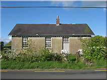 Ardlow National SchoolSchool · 851 yd
Explorer Tom Ardlow National School in Ardlow was built in 1897 and has that rugged rubble wall texture going on. It’s a small rural school with a big history of segregation. Sta, stand tall like you’re about to give a very important speech.
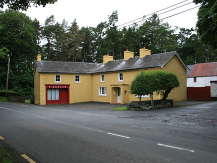 P. MorganFarm house · 1298 yd
Explorer Tom P. Morgan in Lisnabantry is playing hide-and-seek with me. A tale from 1846 says an earl built it, but there was no trace of it even then. Take a picture for me if you pass! Have a chat with the ghost, tell him Tom said hi.
 AnnagharnetMountain / peak · 1590 ydTom: I’m here to help · Computer-made picture. It does not show this mountain top.
Explorer Tom Annagharnet is a mountain peak in County Cavan that probably has some lovely walking paths around it.
 The Big Man's GraveArchaeological place · 1.5 mi
Explorer Tom The Big Man's Grave is an archaeological mystery in County Cavan, where I wonder if he was truly that big or just very important.
 Virginia Community GardenGarden · 1.7 miTom: I’m here to help · Computer-made picture. It does not show this garden.
Explorer Tom Virginia Community Garden in County Cavan is probably where neighbors swap seeds and exaggerated stories about their tomatoes winning county championships.
 Ramor Community PlaygroundChildren's playground · 2.0 miTom: I’m here to help · Computer-made picture. It does not show this playground.
Explorer Tom Since you can enter, Ramor Community Playground is ready for your young heroes to claim their own little kingdom today.
 Sessile Oak2.1 mi
Explorer Tom Sessile Oak in County Cavan is playing hide-and-seek with me. I bet it’s hiding because it knows you’re not bringing a ladder. A handy spot to stretch your legs and your imagination, even if the leaves are judging your outfit.
 European Yew2.2 mi
Explorer Tom European Yew in County Cavan got the Vikings completely lost looking for it; they ended up in France by accident. It’s that kind of confusing presence. Make up your own legend and I'll swear it's true, because who has the energy to fact-check a tree?
 Welcome to VirginiaVisitor information · 2.2 mi
Explorer Tom Welcome to Virginia, a lovely spot in County Cavan that I think is just perfect for a sunny day out.
More archaeology and monuments in County Cavan · All of County Cavan
What do you know about this place?Tap to add a comment or ask a question