
Places near here
Photo credits
- National Inventory of Architectural Heritage
- Oliver Dixon, Geograph · CC BY-SA 2.0
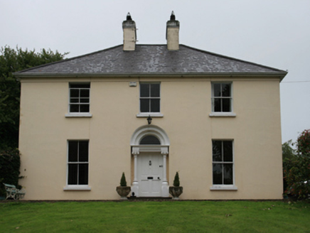 Urcher ManseManse · 221 yd
Explorer Tom Urcher Manse is a substantial Victorian house with a Gothic-Revival doorcase that looks like it wants to scare you out of buying a pint. It’s a former manse in Urcher, so I bet the dog living there thinks he’s the vicar now. Tell the dog I said hi and give him a treat!
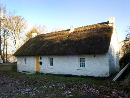 King's CottageHouse · 1099 yd
Explorer Tom King's Cottage handles nosey neighbours by pretending to be a rock that accidentally grew into a house shape. It has small windows that barely let light in, making it perfect for ignoring anyone peeking through the fence while you pretend to be napping in the shadows.
CastleCastle, motte · 1326 ydExplorer Tom Castle in Tanderagee is playing hide-and-seek with me. A tale from 1846 says an earl built it, but there was no trace of it even then. Stand still and listen, the wind tells it better than me.
CarnalynchMountain / peak · 1.0 miExplorer Tom Carnalynch has a secret plan for retirement that involves turning into a very comfortable sofa for tourists who need to take a break from their own bad decisions. It's been saving up its soft spots for decades, waiting for the perfect moment to let out a sigh of relief and invite you to sit down and do absolutely nothing. Ten minutes here and you'll have a yarn for the pub.
DrumacarrowMountain / peak · 1.1 miExplorer Tom Drumacarrow is in a bitter feud with the next village over who owns the rights to the best sunset view, and they’ve been shouting about it for years now. It’s got that intense, competitive energy that makes you want to pick a side just to see which hill ends up throwing first in this ongoing stone war. Have a nosey, politely.
 Brothers GravesVisitor information · 1.4 mi
Explorer Tom Brothers Graves is where seven Marist brothers kicked the bucket after decades of quiet prayer and probably way too much tea. They’re buried right there in Bailieborough Demesne, looking smug about their eternal rest. I bet they’re still judging your posture from under the soil, so stand up straight or else.
In Memory of Patrick KiernanMemorial · 1.4 miExplorer Tom In Memory of Patrick Kiernan is suffering because someone once wrote a truly terrible poem about it and pinned it to a nearby fence. The rhyme scheme was awful and the meter was nonexistent, which has haunted this poor stone ever since then. A handy spot to stretch your legs and your imagination.
Castle Lake ForestForest · 1.6 miExplorer Tom Castle Lake Forest has strict rules that you must whisper when entering, or else the lake will swallow your phone for being too loud. It’s quite particular about manners, so keep your volume down and respect the silence of the water and the surrounding greenery around you. Bring your nan, she'll know more than me.
Drumbannan FortArchaeological place · 1.7 miExplorer Tom Drumbannan Fort in Cavan would tell you everything if you just bought it a few pints of stout and got it properly warmed up and relaxed. It’s been holding onto secrets about ancient kings and their questionable fashion choices for so long that its stones are practically creaking with unspoken stories. Pretend you're a lost aristocrat, nobody will check.
Tullynaskeagh WestForest · 1.7 miExplorer Tom Tullynaskeagh West in County Cavan had a fox take charge of things last Tuesday, and honestly, the management has improved significantly since then. The fox is stricter about boundaries and less likely to ignore your calls for help than the previous regime. Go before the tourists find out.
IndicatedFairy fort / earthen ringfort · 1.7 miExplorer Tom This fairy fort in Leiter has a little dip inside that might be a shortcut, or just a very deep puddle. Don’t trust it too much. A good place to forget your phone for ten minutes.
Rebel HillMemorial · 2.0 miExplorer Tom Rebel Hill refuses to fall down because it knows its 1798 roots are too stubborn for modern gravity. It stands there judging your posture while you try to find the right angle for a photo. Bring a pen pal, they'll be jealous.
More archaeology and monuments in County Cavan · All of County Cavan

What do you know about this place?Tap to add a comment or ask a question