
What is recorded here
From the National Monuments Service (Archaeological Survey of Ireland) record KD018-006002
Places near here
Picture notes
- Computer-made picture. It does not show this monument.
- National Inventory of Architectural Heritage
- Jonathan Billinger, Wikimedia Commons · CC BY-SA 2.0
- Computer-made picture. It does not show this playground.
- Eoghan888 at English Wikipedia, Wikimedia Commons · Public domain
- Alex Passmore, Geograph · CC BY-SA 2.0
- Computer-made picture. It does not show this mountain top.
 Ecclesiastical enclosure in RathernanEcclesiastical enclosure · 2 ydComputer-made picture
Explorer Tom Ecclesiastical enclosure in Rathernan has a bird that refuses to leave, probably thinking he owns the whole wet patch. The wall is just a hedge pretending to be serious, and it’s losing badly. Take a mate and argue about what it was for.
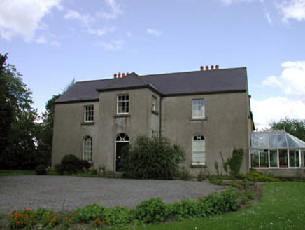 Rathernan HouseRectory/glebe/vicarage/curate's house · 192 yd
Explorer Tom Rathernan House was built by the Board of First Fruits, which sounds like a very expensive fruit salad gone wrong. The vicar who lived here probably had secrets he’d only tell after three pints of stout. Leave nothing behind but your curiosity and a promise to never judge his questionable interior design choices.
 farm house486 yd
Explorer Tom Farm house in Kilmeage would bring a wheelbarrow of potatoes and a very confused sheep to any party. It stands there looking like it knows where the best turnip patch is, despite being surrounded by modern chaos. Give it a pat on the way past, it needs the reassurance.
Kilmeague CastleRuins · 585 yd Fairy fort / earthen ringfort in KilmeageFairy fort / earthen ringfort · 657 ydComputer-made picture
Explorer Tom Fairy fort / earthen ringfort in Kilmeage had a matchmaker who only worked with ghosts. Now it’s just a low rise and some thistles judging your life choices. Best enjoyed with a bag of chips and no plans.
 EnclosureEnclosure, large enclosure · 864 ydComputer-made picture
 Children's playground1154 ydComputer-made pictureBawn in Grangeclare WestBawn · 1.3 mi
Explorer Tom Bawn in Grangeclare West is involved in a tiny fairy dispute over parking rights near the garden centre. It’s an L-shaped ditch that’s mostly filled with organic soil and pure confusion. Walk past slowly like you're in a film.
 Hill of AllenMountain / peak · 1.7 mi
 Grand Canal WayVisitor information · 1.8 mi
 Boston HillMountain / peak · 4.3 miComputer-made picture
 Grange HillMountain / peak · 4.4 miComputer-made picture
More archaeology and monuments in County Kildare · All of County Kildare

What do you know about this place?Tap to add a comment or ask a question