DDiscover AloneMapAbout

Graveyard in Parkavonear

Graveyard
Computer-made picture that does not show Graveyard in ParkavonearNot a photo of this monument
Computer-made picture. It does not show this monument. · Report the wrong picture

The monument record does not grant public access. Check the route and ask the landowner before entering private land.

What do you know about this place?Tap to add a comment or ask a question

What you write will be public.

What is recorded here

In pasture, on a S-facing slope. An irregular-shaped graveyard enclosed by a stone wall (H 1.5m) with entrances in the E end of the N wall and at the SW corner. The interior is uneven and overgrown. The graveyard is currently in use; recent burials are concentrated in the extension immediately E of the graveyard. The…

Read the whole record
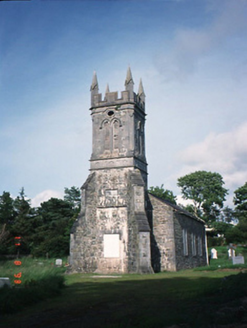
In pasture, on a S-facing slope. An irregular-shaped graveyard enclosed by a stone wall (H 1.5m) with entrances in the E end of the N wall and at the SW corner. The interior is uneven and overgrown. The graveyard is currently in use; recent burials are concentrated in the extension immediately E of the graveyard. The ruins of a church (KE066-016001-) are in the N sector. Uninscribed grave-markers, interspersed with more numerous 18th and 19th-century headstones, are concentrated in the W, SW and N sectors. Within the church, headstones and large tombs date mainly to the 19th century. The oldest inscribed headstone, dating to 1706, is situated in the nave of the church. A large tomb, with a pointed tower inscribed on its upper surface, is located to the SE of the chancel externally. A bullaun stone (KE066-016003-) is located outside the NW corner of the nave. A cross-slab (KE066-016004-) is situated to the NW of the nave, externally. The original location of an ogham stone (KE066-016005-) was to the SW of the church. A round tower (KE066-016006-) is situated in the NW sector. A castle (KE066-017001-) is to the SW of the graveyard. In 2009 a graveyard survey carried out by Stephen Hourihan and Heidi Jacobsen of Headland Archaeology Ltd. on behalf of Kerry County Council, recorded the following details about the graveyard: ‘The boundary walls surrounding the graveyard are of mortared rubble stone with solider rubble stone coping. The main pedestrian entrance to the graveyard is located to the north of the graveyard and consists of one wrought-iron gate between square profile tooled limestone gate piers with stepped chamfered caps. A wrought-iron kissing gate is also located here, situated between one of the gate piers and the rubble stone wall. The entrance gate is in a good state of repair. A second pedestrian entrance is located in the northeast. This consists of a wrought-iron gate between tooled piers. Two pedestrian entrances also exist between the old and the new graveyard. The southernmost of these consists of a wide opening in the rubble stone wall. It appears possible that the opening has been added some time after the original construction of the wall, or at least that it has been remodelled by the addition of cement as a means of supporting the entrance. Further north is a second entrance between the old and new graveyard which is very similar in appearance. The main pathways of Aghadoe churchyard are located in the eastern part. These are gravelled paths which run north/south and east/west, creating a square pattern of rows of graves which are easily and safely accessible without damaging the graves or their integrity. Two paths north of the church are slightly less symmetrical. One appears to have been instated after the original location of several graveplots here and serves as a means of traversing the northernmost part of the graveyard near the main entrance. The second northern path runs in an east/west direction past the church ruin. Like the paths described above these comprise of gravel and are well-kept. There are 34 tombs located within the graveyard. Most of these are concentrated near the church with a few outliers to the south. A total of 694 inscribed headstones belonging to 606 different graves were surveyed. These greatly in style and preservation. The eastern part of the graveyard, consists of neatly planned and well-kept rows of plots with headstones dating mainly to the 20th century. The central part of the graveyard is less strictly planned but well-kept. Many graves date to the 19th century but there are also five graves that date to the 18th century, the oldest headstone, grave no. 720, dates to 1706 and is located in the western part of the church ruin. There are 116 unnamed gravemarkers within Ardcrone graveyard. These are scattered throughout, but are mainly located in the western half of the graveyard. These gravemarkers consists mainly of simple stone markers such as those of grave no's 374 and 396' (Jacobsen 2009, 7-9). See attached plan of graveyard courtesy of Heidi Jacobsen 2009. Revised by: Caimin O'Brien Date of revised upload: 18 November 2022

From the National Monuments Service (Archaeological Survey of Ireland) record KE066-016002

Places near here

Photo credits
  • Berthold Strucken, Wikimedia Commons · CC BY-SA 4.0
  • Maker not stated on source page, www.flickr.com
  • Mike Searle, Geograph · CC BY-SA 2.0
  • Clint Mann, Geograph · CC BY-SA 2.0
  • Bkwillwm, Wikimedia Commons · CC BY-SA 3.0
  • Maker not stated on source page, www.tripadvisor.ru
  • Maker not stated on source page, nexusnewsfeed.com
  • Maker not stated on source page, za.pinterest.com
  • Kmcnamee, Wikimedia Commons · CC BY-SA 4.0
  • National Inventory of Architectural Heritage
  • Maker not stated on source page, www.tripadvisor.com.ph
  • David Medcalf / Geograph, www.geograph.ie
Aghadoe Early Medieval Ecclesiastical SiteHeritage attraction · 26 yd

Explorer Tom Aghadoe's ruined church and round-tower base sit above Killarney with enough carved stone to make you slow down, even…
Ogham Stone (Site of)Ogham stone · 36 yd

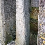
Explorer Tom Ogham Stone in Parkavonear is sick of people asking if it’s haunted by a lonely poet. It’s actually just tired from…

Aghadoe Church (in Ruins)Church · 47 yd

Explorer Tom Aghadoe Church in Parkavonear, County Kerry: Map makers got this one wrong because they kept losing their pencils near…

Round CastleCastle, Anglo-Norman masonry castle · 76 yd

Explorer Tom Round Castle in Parkavonear is sick of people asking if it can still hold a party. It’s got a narrow internal stair…

Parkavonear CastleCastle · 77 yd

Explorer Tom Parkavonear Castle stands below Aghadoe's older church remains, a round Norman tower on a Kerry slope that seems to…

Aghadoe CemeteryCemetery · 128 yd

Explorer Tom Aghadoe Cemetery in County Kerry is guarded by a superstition that says if you sneeze inside the fence, your car won't…

Fairy fort / earthen ringfort in GortareeFairy fort / earthen ringfort · 629 yd

Explorer Tom Fairy fort / earthen ringfort in Gortaree witnessed a love story that went badly wrong right next to its southern…

Church in Gortroe (magunihy By., Killarney Rural Ed)Church · 1181 yd

Explorer Tom Church in Gortroe is where the dead Friars went for their final rest, allegedly. The exact spot is a mystery even the…

St Patricks East Kerry GAA pitchGAA ground · 1238 ydAghadoe ChurchChurch/chapel · 1274 yd

Explorer Tom Aghadoe Church in Knoppoge has an imaginary fan club that only meets during thunderstorms. It’s disused now, but still…

Aghadoe Church of Ireland GraveyardGraveyard · 1290 yd

Explorer Tom Aghadoe Church of Ireland Graveyard in County Kerry has a ghost who is too lazy to haunt anyone, preferring to nap…

Fossa GAA pitchGAA ground · 1404 yd

More archaeology and monuments in County Kerry · All of County Kerry

Add to this placeAdd a picture Add a detailed tip Add a story

Explore the map1,095,414 places to discover

Next place · or swipeAghadoe Early Medieval Ecclesiastical Site